Skip to search
Skip to main content
Skip to first result
Search
You Searched For
%22Austria--Maps%22
Extent of Digitization
Unspecified
New Search
Search Results
Call Number:
1976 1233
Collection Title:
Twenty four new and accurate maps of the several parts of Europe ... : all (except the last) new
Image Count:
1
Alternative Title:
The Swisse Cantons, or Switzerland; with the Grisons Country, &c
Description:
In pencil on verso: 22 .
Subject (Geographic):
Switzerland --Maps --Early works to
Subject (Name):
Barker, B. (Benjamin), d. 1764, bookseller, Clements, Henry, d. 1719, bookseller, King, Charles, d. 1735, bookseller, Nicholson, John, d. ca. 1717, bookseller, Parker, Richard, fl. 1692-1725, bookseller, and Tooke, Benjamin, d. 1716, bookseller
Subject (Topic):
Atlases --Early works to 1800
Collection Created:
[London] : Sold by J. Nicholson at the King’s-Arms in Little Britain, Benj. Barker and Charles King ..., Benj. Tooke ..., Hen. Clements ..., R. Parker and Ralph Smith under the Royal-Exchange ..., [1715?]
Found in:
Beinecke Rare Book and Manuscript Library > Suisse or Switzerland together with their allies & subjects &c
Call Number:
1976 1233
Collection Title:
Forty-two new maps of Asia, Africa, and America ... : all engrav’d, according to the latest
Image Count:
1
Alternative Title:
Abyssinia and Anian, &c
Description:
In ink on verso: 22 .
Subject (Geographic):
Ethiopia --Maps --Early works to 1800
Subject (Name):
Nicholson, John, d. ca. 1717, bookseller
Subject (Topic):
Atlases --Early works to 1800
Collection Created:
London : Printed for J. Nicholson ..., 1716 ...
Found in:
Beinecke Rare Book and Manuscript Library > Abissina and Anian &c
Creator:
Published / Created:
1789 June 1
Call Number:
1982 Folio 10
Image Count:
1
Description:
No. 22 of 43 maps bound together in
Publisher:
W. Faden
Subject (Geographic):
Germany --Maps --Early works to 1800
Subject (Name):
Brunswick-Luneburg, House of
Found in:
Beinecke Rare Book and Manuscript Library > A new map of the King of Great Britain's dominions in Germany or the electorate of Brunswick-Luneburg and its dependencies
Published / Created:
1595
Call Number:
Taylor 219
Collection Title:
Navigatio ac itinerarivm Iohannis Hvgonis Linscotani in Orientalem sive Lvsitanorvm Indiam
Image Count:
1
Description:
Bound in following page 22 .
Subject (Geographic):
Borneo --Maps
Subject (Name):
Claesz, Cornelis, ca. 1546-1609, publisher, Elzevier, Gillis, bookseller, Hendricksz, Aelbrecht, fl. 1573-1605, printer, and Langren, Arnold Florent van, 1580-1644
Subject (Topic):
Voyages and travels --Early works to 1800
Collection Created:
Hagae-Comitis : Ex officina Alberti Henrici, impensis authoris & Cornelii Nicolai, prostantque apud Aegidium Elseuirum, anno 1599
Found in:
Beinecke Rare Book and Manuscript Library > Exacta & accurata delineatio cum orarum maritimarum tum etiam locorum terrestrium quae in regionibus China, Cauchinchina, Camboia sive Champa, Syao, Malacca, Arracamn & Pegu ...
Creator:
Map Company, issuing body
Published / Created:
1922
Call Number:
766 F16 1922
Image Count:
22
Resource Type:
Maps , Atlases & Globes
Abstract:
Sanborn fire insurance maps are a rich
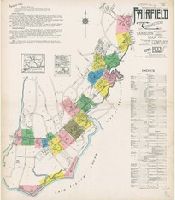
Alternative Title:
Apr. 1922, Fairfield, Conn.
Description:
"22 sheets (5093)."
Subject (Geographic):
Fairfield (Conn.)--Maps
Subject (Name):
Library of Congress Stamp
Subject (Topic):
--Fairfield--Maps
Found in:
Beinecke Rare Book and Manuscript Library > Fairfield, Fairfield County, Connecticut.
Creator:
Map Company, issuing body
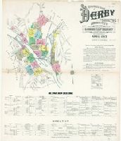
Published / Created:
1912
Call Number:
766 D444 1912
Image Count:
22
Resource Type:
Maps , Atlases & Globes
Abstract:
Sanborn fire insurance maps are a rich
Alternative Title:
Apr. 1912, Derby, Conn., Apr. 1912, Derby, Conn. Shelton., and Derby and Shelton, New Haven County, Connecticut.
Description:
"22 sheets. (4763)."
Subject (Geographic):
Derby (Conn.)--Maps
Subject (Name):
Library of Congress. Map Division Stamp
Subject (Topic):
--Derby--Maps
Found in:
Beinecke Rare Book and Manuscript Library > Insurance maps of Derby and Shelton, New Haven County, Connecticut.
Creator:
Published / Created:
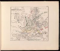
[1840?]
Call Number:
2002 Folio 32
Image Count:
1
Description:
de 22 aôut, 1852, Belgique, France
Publisher:
Librarie Militaire de J.-B. Petit,
Subject (Geographic):
France--History--Revolution--Maps
Subject (Name):
Napoleon--I,--Emperor of the French,--1769-1821
Found in:
Beinecke Rare Book and Manuscript Library > Atlas portatif pour l'intelligence des relations des dernières guerres : publiées sans plans ; notamment pour la vie de Napoléon.
Creator:
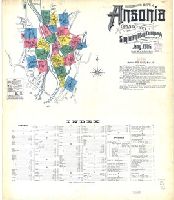
Map Company, issuing body
Published / Created:
1906
Call Number:
766 An81 1906
Image Count:
22
Resource Type:
Maps , Atlases & Globes
Abstract:
Sanborn fire insurance maps are a rich
Alternative Title:
Ansonia, Connecticut and Jan. 1906, Ansonia, Conn.
Description:
"22 sheets (8531)."
Subject (Geographic):
Ansonia (Conn.)--Maps
Subject (Name):
Library of Congress. Map Divison Stamp
Subject (Topic):
--Ansonia--Maps
Found in:
Beinecke Rare Book and Manuscript Library > Insurance maps of Ansonia, Connecticut, New Haven County.
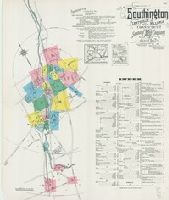
Creator:
Map Company, issuing body
Published / Created:
1923
Call Number:
766 So87 1923
Image Count:
22
Resource Type:
Maps , Atlases & Globes
Abstract:
Sanborn fire insurance maps are a rich
Alternative Title:
Mar. 1923, Southington, Conn.
Description:
"22 sheets. (5907)."
Subject (Geographic):
Southington (Conn.)--Maps
Subject (Name):
Library of Congress Stamp
Subject (Topic):
--Southington--Maps
Found in:
Beinecke Rare Book and Manuscript Library > Southington, including Plantsville and Milldale, Hartford County, Connecticut.
Creator:
Published / Created:
[1783?]
Call Number:
1977 Folio 177
Image Count:
4
Resource Type:
Maps , Atlases & Globes
Description:
measure 70.0 x 50.5 cm or smaller. No. 22 of
Publisher:
Printed for Thomas Jefferys,
Subject (Geographic):
Great Britain--Maps --Early works to
Found in:
Beinecke Rare Book and Manuscript Library > England and Ireland : containing all the cities, boroughs, markettowns & principal villages : with the coast of France from Calais to Brest delineated and engraved from actual surveys / by Richard William Seale.
Branch:v1.61.8 ,Deployed:2024-06-20T11:14:46-04:00