Skip to search
Skip to main content
Skip to first result
Search
You Searched For
Extent of Digitization
Completely digitized
Creator
Great Britain. War Office. General Staff. Geographical Section
Publication Place
[London] :
Search Results
Creator:
Published / Created:
1942
Call Number:
66gmb 1942
Container / Volume:
BRBL_00348
Image Count:
1
Resource Type:
Maps, Atlases & Globes
Alternative Title:
[G.S.G.S.] 4256 and GSGS (Series) ; 4256.
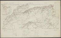
Description:
"Copied from a French (Michelin) map [sheet 151] dated 1939."
Publisher:
GSGS,
Subject (Geographic):
Africa, North--Maps
Subject (Name):
Pneu Michelin (Firm)
Subject (Topic):
Roads--Africa, North--Maps, Roads--Algeria--Maps, Roads--Morocco--Maps, and Roads--Tunisia--Maps
Found in:
Beinecke Rare Book and Manuscript Library > Africa road map 1:2,000,000 and 1:500,000, Maroc-Algerie-Tunisie.
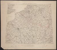
Creator:
Published / Created:
1910
Call Number:
335 1910
Container / Volume:
BRBL_00086
Image Count:
1
Resource Type:
Maps, Atlases & Globes
Alternative Title:
GSGS (Series) 2517
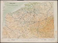
Description:
Shows canals, railways, roads and some military features.
Publisher:
Geographical Section, General Staff,
Subject (Geographic):
Belgium--Maps and France--Maps
Subject (Topic):
Transportation--Belgium--Maps and Transportation--Roads--Maps
Found in:
Beinecke Rare Book and Manuscript Library > Belgium and the north east of France G.S.G.S. 2517 [cartographic material].
Creator:
Published / Created:
1943-
Call Number:
11hd 1942D-44
Image Count:
14
Resource Type:
Maps, Atlases & Globes
Alternative Title:
[Series] M641, G.S.G.S ; no. 4416, and GSGS (Series) ; 4416.
Description:
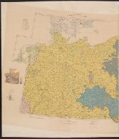
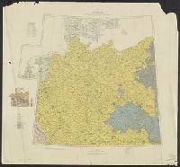
Marginal maps: Index to adjoining sheets and incidence of grid letters [and] G.S.G.S. 4346, Germany 1:250,000.--Compilation diagram.
Publisher:
War Office,
Subject (Geographic):
Europe, Central--Maps and Germany--Maps
Found in:
Beinecke Rare Book and Manuscript Library > Central Europe 1:100,000.
Creator:
Published / Created:
1918
Call Number:
36ed 1918
Container / Volume:
BRBL_00127
Image Count:
2
Resource Type:
Maps, Atlases & Globes
Alternative Title:
GSGS (Series) ; 3703a. and GSGS ; 3703a
Description:
Germany -- Poland -- Northern Italy -- South east Europe.
Publisher:
War Office,
Subject (Geographic):
Balkan Peninsula--Maps, Germany--Maps, Italy, Northern--Maps, and Poland--Maps
Found in:
Beinecke Rare Book and Manuscript Library > Ethnographical map [cartographic material].
Creator:
Published / Created:
1918
Call Number:
11hcf 1919D-5
Image Count:
1
Resource Type:
Maps, Atlases & Globes
Alternative Title:
G.S.G.S. ; no. 3703a and GSGS (Series) ; 3703a.
Description:
Includes graph of "Population of certain towns in Schleswig-Holstein," and index to adjoining maps in series.
Publisher:
War Office [G.S.G.S.],
Subject (Topic):
Ethnology--Europe, Central--Maps, Ethnology--Germany--Maps, Population density--Europe, Central--Maps, and Population density--Germany--Maps
Found in:
Beinecke Rare Book and Manuscript Library > Germany ethnographical map.
Creator:
Published / Created:
1944
Call Number:
428 IN7 1944
Container / Volume:
BRBL_00248
Image Count:
2
Resource Type:
Maps, Atlases & Globes
Alternative Title:
G.S.G.S. ; 4483 and GSGS (Series) ; 4483.
Description:
"Copied from an Austrian plan. Drafting and reproduction by 654th Engineers, U.S. Army."
Publisher:
War Office,
Subject (Geographic):
Innsbruck (Austria)--Maps
Found in:
Beinecke Rare Book and Manuscript Library > Innsbruck and Environs [cartographic material].
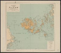
Creator:
Published / Created:
1919
Call Number:
3481 1919
Container / Volume:
BRBL_00099
Image Count:
1
Resource Type:
Maps, Atlases & Globes
Alternative Title:
G.S.G.S. ; no. 2928 and GSGS (Series) ; no. 2928.
Description:
Copy of Swedish map published by Generalstabens Litografiska Anstalts. No additions; retains Swedish legend.
Publisher:
War Office,
Subject (Geographic):
Åland (Finland)--Maps
Found in:
Beinecke Rare Book and Manuscript Library > Karta över Åland / utarbetad vid Generalstabens Litogr. Anstalt.
Creator:
Published / Created:
[1918?]
Call Number:
38fd 1918
Container / Volume:
BRBL_00170
Image Count:
1
Resource Type:
Maps, Atlases & Globes
Alternative Title:
GSGS (Series) ; 3700.
Description:
"G.S.G.S. 3700."
Publisher:
Ordnance Survey,
Subject (Geographic):
Belgium--Boundaries--France--Maps, France--Boundaries--Belgium--Maps, France--Boundaries--Germany--Maps, and Germany--Boundaries--France--Maps
Subject (Name):
Great Britain. Ordnance Survey
Found in:
Beinecke Rare Book and Manuscript Library > North-east frontier of France [cartographic material].
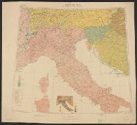
Creator:
Published / Created:
1918
Call Number:
11hcf 1919D-6
Image Count:
1
Resource Type:
Maps, Atlases & Globes
Alternative Title:
G.S.G.S. ; 3703a and GSGS (Series) ; 3703a.
Description:
Includes graph "Population of certain towns." and index to adjoining maps in series.
Publisher:
War Office [G.S.G.S.],
Subject (Geographic):
Balkan Peninsula--Maps, Europe, Central--Maps, and Italy--Maps
Subject (Topic):
Ethnology--Balkan Peninsula--Maps, Ethnology--Europe, Central--Maps, Ethnology--Italy--Maps, Population density--, Population density--Balkan Peninsula--Maps, and Population density--Europe, Central--Maps
Found in:
Beinecke Rare Book and Manuscript Library > Northern Italy ethnographical map [cartographic material].
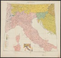
Creator:
Published / Created:
1918
Call Number:
40ed 1918
Container / Volume:
BRBL_00229
Image Count:
1
Resource Type:
Maps, Atlases & Globes
Alternative Title:
G.S.G.S. ; 3703a and GSGS (Series) ; 3703a.
Description:
Includes graph "Population of certain towns." and index to adjoining maps in series.
Publisher:
War Office [G.S.G.S.],
Subject (Geographic):
Balkan Peninsula--Maps, Europe, Central--Maps, and Italy--Maps
Subject (Topic):
Ethnology--Balkan Peninsula--Maps, Ethnology--Europe, Central--Maps, Ethnology--Italy--Maps, Population density--, Population density--Balkan Peninsula--Maps, and Population density--Europe, Central--Maps
Found in:
Beinecke Rare Book and Manuscript Library > Northern Italy ethnographical map [cartographic material].
Branch:v1.68.6 ,Deployed:2025-07-02T08:09:34-04:00