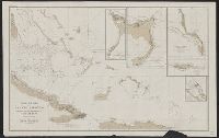
Imperfect. Chipped with possible loss of text., Includes references and 5 insets., and Relief shown by hachures and spot heights. Depths shown by soundings.
Publisher:
U.S. Coast and Geodetic Survey,
Subject (Geographic):
Bahamas--Discovery and exploration--Maps and Bahamas--Maps
Coast chart ; no. 103(2), Mount Desert Island Maine, and U.S.C. & G.S. (Series) ; no. 103(2)
Description:
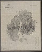
Includes a chart of heights of mountains and hills above mean high water, a chart of summer level of lakes and ponds above mean high water, and latitude and longitude of Baker's I Light House and Mt. Desert light on Green Mt. and Relief shown by hachures.
Publisher:
U.S. Coast and Geodetic Survey,
Subject (Geographic):
Maine--Maps
Subject (Name):
Donn, J. W. (John W.), 1835-1905, Hilgard, J. E. (Julius Erasmus), 1825-1891, and Patterson, C. P. (Carlile Pollock), 1816-1881
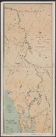
"Distances from Juneau to the mouth of the Porcupine River"., Ms. notes recto and verso., Oriented with north toward upper right., and Relief shown by hachures and spot heights.
Publisher:
U.S. Coast and Geodetic Survey,
Subject (Geographic):
Alaska--Maps, British Columbia--Maps, and Yukon--Maps
[Chart] : no. 654. and U.S. Coast and Geodetic Survey. Chart ; no. 654.
Description:
"Aids to navigation corrected to 1880.", "Electrotype copy no. 1 by G. Mathiot U.S.C.S.", Includes text., Relief shown by hachures and spot heights; depths shown by soundings., and Shows Strait of Juan de Fuca region.
Publisher:
Coast and Geodetic Survey,
Subject (Geographic):
Juan de Fuca, Strait of, Region (B.C. and Wash.)--Maps
Subject (Topic):
Nautical charts--Juan de Fuca, Strait of, Region (B.C. and Wash.)