Skip to search
Skip to main content
Skip to first result
Search
You Searched For
Extent of Digitization
Completely digitized
Format
cartographic
Publication Place
London
Search Results
Creator:
Published / Created:
1795
Call Number:
Osborn pc259
Image Count:
4
Resource Type:
Maps, Atlases & Globes
Alternative Title:
Bowles's geographical game of Europe, in a new, complete, and elegant tour through the different kingdoms, states, cities, &c. of Europe : designed by Dr. Nugent and Game of Geography
Description:
Imperfect: wanting totum, pillars and counters.
Publisher:
Printed for the proprietors Bowles & Carver
Subject (Topic):
Geographical recreations --Europe --Early works to 1800 and Publishers’ advertisements --England --London --1795
Found in:
Beinecke Rare Book and Manuscript Library > Bowles's European geographical amusement, or, Game of geography ; designed from The grand tour of Europe, by Dr. Nugent
Creator:
Published / Created:
[1862?]
Call Number:
754 1861B
Container / Volume:
BRBL_00416
Image Count:
1
Resource Type:
Maps, Atlases & Globes
Description:
A list of other maps and atlases by Wyld is pasted on the verso.
Subject (Geographic):
Southern States--Maps
Found in:
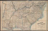
Beinecke Rare Book and Manuscript Library > Map of the southern states of North America with the forts, harbours & military positions James Wyld, Geographer to the Queen.
Creator:
Published / Created:
[between 1890 and 1900]
Call Number:
BrSides Double Folio 2019 10
Image Count:
1
Resource Type:
Maps, Atlases & Globes
Description:
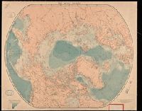
London Atlas Series" and "Stanford's Geographical Estabt., London" printed below lower corners.
Publisher:
Edward Stanford, 12, 13 & 14, Long Acre, W.C.
Subject (Geographic):
Arctic regions--Discovery and exploration--Maps.
Subject (Topic):
Discoveries in geography--Maps
Found in:
Beinecke Rare Book and Manuscript Library > The arctic regions.
Branch:v1.68.6 ,Deployed:2025-07-02T08:09:31-04:00