Search
You Searched For
Search Results
- Creator:
- Geological Survey (U.S.)
- Published / Created:
- 1909
- Call Number:
- 848 1909
- Container / Volume:
- BRBL_00630
- Image Count:
- 1
- Resource Type:
- Maps, Atlases & Globes
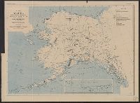
- Description:
- "Alaska, map A."
- Publisher:
- The Survey,
- Subject (Geographic):
- Alaska--Maps and Yukon Territory--Maps
- Subject (Name):
- Brooks, Alfred Hulse, 1871-1924
- Found in:
- Beinecke Rare Book and Manuscript Library > Map of Alaska / compiled chiefly from maps of the U.S. Geological Survey ... Alfred H. Brooks, geologist in charge, Division of Alaskan Mineral Resources.
- Creator:
- Geological Survey (U.S.)
- Published / Created:
- 1913
- Call Number:
- 848 1913A
- Container / Volume:
- BRBL_00631
- Image Count:
- 2
- Resource Type:
- Maps, Atlases & Globes
- Description:
- "Index map showing areas covered by topographic maps, August 1913".
- Publisher:
- U.S. Geological Survey,
- Subject (Geographic):
- Alaska--Maps
- Found in:
- Beinecke Rare Book and Manuscript Library > Map of Alaska : compiled chiefly from maps of the U.S. Geological Survey / engraved and printed by the U.S. Geological Survey ; Alfred H. Brooks, Geologist in charge, Division of Alaskan Mineral Resources.
- Creator:
- Geological Survey (U.S.)
- Published / Created:
- 1908
- Call Number:
- 848gbc 1908
- Container / Volume:
- BRBL_00635
- Image Count:
- 1
- Resource Type:
- Maps, Atlases & Globes
- Alternative Title:
- Bulletin (United States. Bureau of Mines) ; 36. and Bureau of Mines Bulletin ; no. 36
- Description:
- In upper margin: "Bureau of Mines, Bulletin no. 36, Plate I."
- Publisher:
- Geological Survey,
- Subject (Geographic):
- Alaska--Maps
- Subject (Name):
- Brooks, Alfred H. (Alfred Hulse), 1871-1924
- Subject (Topic):
- Mines and mineral resources--Alaska--Maps
- Found in:
- Beinecke Rare Book and Manuscript Library > Map of Alaska showing the known distribution of mineral resources / U.S. Geological Survey, compiled under the direction of Alfred H. Brooks, Geologist in charge of Division of Alaskan Mineral Resources, U.S. Geological Survey.
- Creator:
- Geological Survey (U.S.)
- Published / Created:
- 1893
- Call Number:
- 766 1893
- Container / Volume:
- BRBL_00467
- Image Count:
- 4
- Resource Type:
- Maps, Atlases & Globes
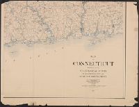
- Description:
- Contour interval 100 feet.
- Publisher:
- US Geological Survey,
- Subject (Geographic):
- Connecticut--Maps
- Found in:
- Beinecke Rare Book and Manuscript Library > Map of Connecticut / prepared by the U.S. Geological Survey in co-operation with the State of Connecticut.
- Creator:
- Geological Survey (U.S.)
- Published / Created:
- 1893 (1899 printing)
- Call Number:
- 766 1893C
- Container / Volume:
- BRBL_00467
- Image Count:
- 2
- Resource Type:
- Maps, Atlases & Globes
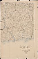
- Description:
- "Reprinted Sept. 1899."
- Publisher:
- US Geological Survey,
- Subject (Geographic):
- Connecticut--Maps
- Found in:
- Beinecke Rare Book and Manuscript Library > Map of Connecticut / prepared by the U.S. Geological Survey in co-operation with the State of Connecticut.
- Creator:
- Geological Survey (U.S.)
- Published / Created:
- 1893 (1899 printing)
- Call Number:
- 766 1893C
- Container / Volume:
- BRBL_00467
- Image Count:
- 3
- Resource Type:
- Maps, Atlases & Globes
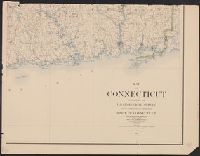
- Description:
- "Reprinted Sept. 1899."
- Publisher:
- US Geological Survey,
- Subject (Geographic):
- Connecticut--Maps
- Found in:
- Beinecke Rare Book and Manuscript Library > Map of Connecticut / prepared by the U.S. Geological Survey in co-operation with the State of Connecticut.
- Creator:
- Geological Survey (U.S.)
- Published / Created:
- 1912
- Call Number:
- 71 1912
- Container / Volume:
- BRBL_00371
- Image Count:
- 1
- Resource Type:
- Maps, Atlases & Globes
- Description:
- Includes inset of Aleutian Islands and Windward Islands.
- Publisher:
- Engraved and printed by the U.S. Geological Survey,
- Subject (Geographic):
- North America--Maps
- Found in:
- Beinecke Rare Book and Manuscript Library > Map of North America : reduced from map on scale of 1:5,000,000 / compiled by the U.S. Geological Survey.
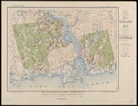
- Creator:
- Geological Survey (U.S.)
- Published / Created:
- 1915
- Call Number:
- 766C Sa99 1915
- Container / Volume:
- BRBL_00474
- Image Count:
- 1
- Resource Type:
- Maps, Atlases & Globes
- Alternative Title:
- Water-Supply Paper 374
- Description:
- From Water-Supply Paper 374, plate 13.
- Publisher:
- U.S. Geological Survey,
- Subject (Geographic):
- Saybrook (Conn.)--Maps
- Subject (Topic):
- Groundwater--Connecticut--Saybrook--Maps and Water-supply--Connecticut--Saybrook--Maps
- Found in:
- Beinecke Rare Book and Manuscript Library > Map of Saybrook area, Connecticut, showing rock outcrops, wooded areas, and ground-water conditions.
- Creator:
- Geological Survey (U.S.)
- Published / Created:
- 1882]
- Call Number:
- 779 1882
- Container / Volume:
- BRBL_00505
- Image Count:
- 1
- Resource Type:
- Maps, Atlases & Globes
- Description:
- Road map of area including D.C., Alexandria, Fairfax, Prince Georges, and lower Montgomery counties.
- Publisher:
- s.n.,
- Subject (Geographic):
- Washington Metropolitan Area--Road maps and Washington Region--Road maps
- Found in:
- Beinecke Rare Book and Manuscript Library > Map of Washington and vicinity / prepared at the office of the U.S. Geological Survey, 1882.
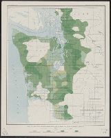
- Creator:
- Geological Survey (U.S.)
- Published / Created:
- [1898].
- Call Number:
- 847gc 1898
- Container / Volume:
- BRBL_00628
- Image Count:
- 1
- Resource Type:
- Maps, Atlases & Globes
- Description:
- "Julius Bien & Co. Lith. N.Y."
- Publisher:
- The Survey,
- Subject (Name):
- Geological Survey (U.S.). Annual report
- Subject (Topic):
- Forests and forestry--Washington (State), Western--Maps
- Found in:
- Beinecke Rare Book and Manuscript Library > Map of Western Washington showing density of merchantable timber / U.S. Geological Survey.