Gussefeld, F. L. (Franz Ludwig), 1744-1807 Homann Erben (Firm)
Published / Created:
1786
Call Number:
1983 Folio 23
Collection Title:
[Atlas factice of 50 maps, primarily by Johann Baptist Homann and/or issued by the Homann Erben
Image Count:
1
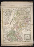
Alternative Title:
Carte geographique du Cercle de Haut-Rhin and Charte ueber die am Ober-Rhein zerstreut liegende Laender des Ober-Rheinischen Kreise
Publisher:
Bey denen Homaennischen Erben
Subject (Geographic):
Baden-Wu?rttemberg (Germany) --Maps --Early works to 1800, Hesse (Germany) --Maps --Early works to 1800, North Rhine-Westphalia (Germany) --Maps --Early works to 1800, and Rhineland-Palatinate (Germany) --Maps --Early works to 1800
Gussefeld, F. L. (Franz Ludwig), 1744-1807 Homann Erben (Firm) Schmidt, I. M.
Published / Created:
1783
Call Number:
1983 Folio 23
Collection Title:
[Atlas factice of 50 maps, primarily by Johann Baptist Homann and/or issued by the Homann Erben
Image Count:
1
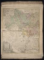
Alternative Title:
Carte geographique contenant le cours du Rhin, de la Meuse, & de la Moselle avec les cercles du haut- & bas-Rhin, le Duchee de Lorraine & d’Elsas & cc
Publisher:
Bey denen Homaen[n]ischen Erben
Subject (Geographic):
Germany, Southern --Maps --Early works to 1800, Hesse (Germany) --Maps --Early works to 1800, and Rhineland-Palatinate (Germany) --Maps --Early works to 1800
Gussefeld, F. L. (Franz Ludwig), 1744-1807 Homann Erben (Firm)
Published / Created:
1783
Call Number:
1983 Folio 23
Collection Title:
[Atlas factice of 50 maps, primarily by Johann Baptist Homann and/or issued by the Homann Erben
Image Count:
1
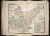
Alternative Title:
Circuli superioris Saxoniae pars meridionalis, Ducatum, Electoratum & Principatus Ducum Saxoniae, Princip. Anhalt. Comit. Schwarzburg, Mansfeld, Stolberg &cc
Publisher:
[Homann Erben]
Subject (Geographic):
Brandenburg (Germany) --Maps --Early works to 1800, Saxony (Germany) --Maps --Early works to 1800, Saxony-Anhalt (Germany) --Maps --Early works to 1800, and Thuringia (Germany) --Maps --Early works to 1800
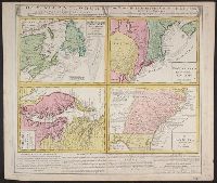
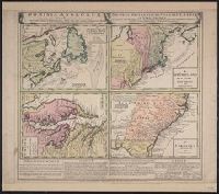
Gros-Britannische Colonie-Lænder in Nord-America, in accuraten Special-Mappen nach den London. Originalien gretreulich mitgetheilt und heraussgegeben von Homaennischen Erben
Description:
A. New Foundland od. Terra Nova, S. Laurentii Bay, die Fisch-Bank, Acadia, nebst einem Theil New Schotland -- B. New Engelland, New York, New Yersey und Pensilvania -- C. Virginia und Maryl
Publisher:
Homannianis Hered.,
Subject (Geographic):
Atlantic Coast (Canada)--Maps--Early works to 1800, Atlantic Coast (U.S.)--Maps--Early works to 1800, and Great Britain--Colonies--America--Maps--Early works to 1800
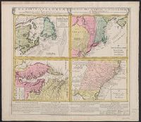
Gros-Britannische Colonie-Lænder in Nord-America, in accuraten Special-Mappen nach den London. Originalien gretreulich mitgetheilt und heraussgegeben von Homaennischen Erben
Description:
"Mit Kayserl. allergn. Privil."
Publisher:
Homannianis Hered.,
Subject (Geographic):
Atlantic Coast (Canada)--Maps--Early works to 1800, Atlantic Coast (U.S.)--Maps--Early works to 1800, and Great Britain--Colonies--America--Maps--Early works to 1800
Gros-Britannische Colonie-Lænder in Nord-America, in accuraten Special-Mappen nach den London. Originalien gretreulich mitgetheilt und heraussgegeben von Homaennischen Erben
Description:
A. New Foundland od. Terra Nova, S. Laurentii Bay, die Fisch-Bank, Acadia, nebst einem Theil New Schotland -- B. New Engelland, New York, New Yersey und Pensilvania -- C. Virgin
Publisher:
Homannianis Hered.,
Subject (Geographic):
Atlantic Coast (Canada)--Maps--Early works to 1800, Atlantic Coast (U.S.)--Maps--Early works to 1800, and Great Britain--Colonies--America--Maps--Early works to 1800
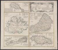
Antigua--Maps--Early works to 1800, B, Barbados--Maps--Early works to 1800, Jamaica--Maps--Early works to 1800, Saint Kitts and Nevis--Maps--Early works to 1800, and West Indies--Maps--Early works to 1800
Antigua--Maps--Early works to 1800, Barbados--Maps--Early works to 1800, Bermuda Islands--Maps--Early works to 1800, Jamaica--Maps--Early works to 1800, and Saint Kitts and Nevis--Maps--Early works to 1800
[Atlas factice of 50 maps, primarily by Johann Baptist Homann and/or issued by the Homann Erben
Image Count:
1
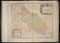
Alternative Title:
Ducatus Silesiae tabula geographica generalis, Duche de Silesie suivant l’e´tat present drese par Tobie Maier, et publie par les Heritiers de Homann a Nuremberg, and Dvche de Silesie suivant l’etat present drese par Tobie Maier, et publie par les Heritiers de Homann a Nuremberg
Publisher:
Impensis Homannianorum Heredum
Subject (Geographic):
Silesia (Czech Republic) --Maps --Early works to 1800