Skip to search
Skip to main content
Skip to first result
Search
You Searched For
Genre
Maps
Creator
U.S. Coast and Geodetic Survey
New Search
Search Results
Creator:
Published / Created:
1944
Call Number:
50 1945I
Container / Volume:
BRBL_00273
Image Count:
2
Resource Type:
Maps, Atlases & Globes
Description:
Cloth map., Includes text., Relief shown by gradient tints, contours, and spot heights., and Text in English and 6 other languages.
Publisher:
Amy Map Service,
Subject (Geographic):
Kunming Region (China)--Maps
Subject (Name):
United States. Aeronautical Chart Service, United States. Army Air Forces, and United States. Army Map Service
Subject (Topic):
Military maps
Found in:
Beinecke Rare Book and Manuscript Library > AAF cloth chart. No. 133, Kun-Ming, Yunnan, China to Chabua, Assam, India Forces / prepared under the direction of the Commanding General, Army Air Forces, for the Aeronautical Chart Service, by the U.S. Coast and Geodetic Survey, Washington, D.C., Januar
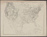
Creator:
Published / Created:
1880
Call Number:
75AK 1880
Container / Volume:
BRBL_00407A
Image Count:
1
Resource Type:
Maps, Atlases & Globes
Publisher:
U.S. Coast and Geodetic Survey,
Subject (Geographic):
United States--Maps
Found in:
Beinecke Rare Book and Manuscript Library > Base-map of the United States / Drawn and engraved by A. and H. Lindenkohl.
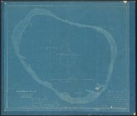
Creator:
Published / Created:
1893?]
Call Number:
23 C61 1893
Container / Volume:
BRBL_00020
Image Count:
1
Resource Type:
Maps, Atlases & Globes
Description:
Blueprint. and Handwritten on original, following author's name: Who has kindly permitted this tracing to be taken for the use of the United States Coast & Geodetic Survey.
Publisher:
United States Coast & Geodetic Survey?
Subject (Geographic):
Clipperton Island--Maps
Found in:
Beinecke Rare Book and Manuscript Library > Clipperton Island, North Pacific Ocean / surveyed 1893 by Carl C. Jensen.
Creator:
Published / Created:
1900
Call Number:
767cea 1900
Container / Volume:
BRBL_00476
Image Count:
1
Resource Type:
Maps, Atlases & Globes
Alternative Title:
Connecticut River, Connecticut River, Deep River to Higganum, U.S.C. & G.S. (Series) ; 254., and U.S.C. & G.S. ; 254
Description:
"Date of first publication 1895.", "Electrotype copy no. 1 U.S.C. & G.S."--Upper right margin., "Soundings in feet.", Depths shown by shading and soundings., Includes tidal information., Oriented with north toward upper right corner., Plate no. 2659., and Relief sho
Publisher:
U.S. Coast and Geodetic Survey,
Subject (Geographic):
Connecticut River--Navigation
Subject (Topic):
Nautical charts--Connecticut River
Found in:
Beinecke Rare Book and Manuscript Library > Connecticut River, Deep River to Higganum, Connecticut / U.S. Coast and Geodetic Survey.
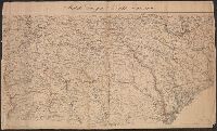
Creator:
Published / Created:
[1861?]
Call Number:
754 1861C
Container / Volume:
BRBL_00416
Image Count:
1
Resource Type:
Maps, Atlases & Globes
Description:
["Chas. G. Krebs, Lith."], ["Drawn by A. Lindenkohl."], and See Phillips, p. 299.
Publisher:
U.S. Coast Survey,
Subject (Geographic):
Georgia--Maps and South Carolina--Maps
Subject (Name):
Krebs, Charles G and Lindenkohl, A
Found in:
Beinecke Rare Book and Manuscript Library > Middle Georgia & South Carolina.
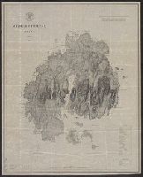
Creator:
Published / Created:
1875
Call Number:
761 M86 1875
Container / Volume:
BRBL_00448
Image Count:
1
Resource Type:
Maps, Atlases & Globes
Alternative Title:
Coast chart ; no. 103(2), Mount Desert Island Maine, and U.S.C. & G.S. (Series) ; no. 103(2)
Description:
Includes a chart of heights of mountains and hills above mean high water, a chart of summer level of lakes and ponds above mean high water, and latitude and longitude of Baker's I Light House and Mt. Desert light on Green Mt. and Relief shown by hachures.
Publisher:
U.S. Coast and Geodetic Survey,
Subject (Geographic):
Maine--Maps
Subject (Name):
Donn, J. W. (John W.), 1835-1905, Hilgard, J. E. (Julius Erasmus), 1825-1891, and Patterson, C. P. (Carlile Pollock), 1816-1881
Subject (Topic):
Nautical charts--Maine
Found in:
Beinecke Rare Book and Manuscript Library > Mt. Desert Island Maine / C.P Patterson, Superintendent ; verified, J.E. Hilgard, Assistant in Charge of Office ; topography surveyed by J.W. Donn.
Creator:
Published / Created:
1886]
Call Number:
73cea 1886
Container / Volume:
BRBL_00375B
Image Count:
2
Resource Type:
Maps, Atlases & Globes
Alternative Title:
Cape Flattery to Dixon entrance., Dixon entrance to Cape St. Elias., and Northwest coast of America
Description:
Date below scale: 1868., In upper margin of sheet no. 2: No. 701 ... plate no. 1880., In upper right margins: Electrotype copy no. 1 U.S.C.&G.S., and Sheet no. 1. Cape Flattery to Dixon entrance -- Sheet no. 2. Dixon entrance to Cape St. Elias : compiled from Br
Publisher:
U.S. Coast and Geodetic Survey?,
Subject (Geographic):
Pacific Coast (Alaska)--Maps and Pacific Coast (B.C.)--Maps
Subject (Name):
Dall, William Healey, 1845-1927, Davidson, George, 1825-1911, and Nichols, H. E. (Henry Ezra)
Found in:
Beinecke Rare Book and Manuscript Library > North west coast of America.
Creator:
Published / Created:
1944
Call Number:
28 Ap11 1944
Container / Volume:
BRBL_00023E
Image Count:
1
Resource Type:
Maps, Atlases & Globes
Alternative Title:
A.M.S. ; S901, Aparri, Philippine Islands, Cagayan Province, and Series (Standard map series designation system) ; S901.
Description:
"Copied from U.S.C. & G.S. chart 4260." and Important buildings are named; soundings are given.
Publisher:
The Service,
Subject (Geographic):
Aparri (Philippines)--Maps
Found in:
Beinecke Rare Book and Manuscript Library > Philippine Islands city plans. Aparri.
Branch:v1.61.6 ,Deployed:2024-06-12T09:55:31-04:00