Skip to search
Skip to main content
Skip to first result
Search
You Searched For
Genre
Nautical charts
Creator
U.S. Coast and Geodetic Survey
New Search
Search Results
Creator:
Published / Created:
1898
Call Number:
855hc 1898Q
Container / Volume:
BRBL_00765
Image Count:
1
Resource Type:
Maps, Atlases & Globes
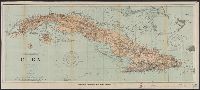
Description:
"482.", "Date of publication July 1898.", "To accompany report of Major General Commanding for 1898" outside lower margin., Includes compass rose., and Relief shown by hachures. Depths shown by soundings and isolines.
Publisher:
The Survey,
Subject (Geographic):
Cuba--Maps
Subject (Topic):
Nautical charts--Cuba
Found in:
Beinecke Rare Book and Manuscript Library > Cuba : part of chart "E" / Treasury Department, U.S. Coast and Geodetic Survey, Henry S. Pritchett, Superintendent.
Creator:
Published / Created:
1886
Call Number:
761cea M86 1882
Container / Volume:
BRBL_00449
Image Count:
1
Resource Type:
Maps, Atlases & Globes
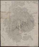
Alternative Title:
Map ; no. 292, plate no. 1686 and Map ; no. 292, plate no. 1686.
Description:
Aids to navigation corrected to 1886.
Publisher:
U.S. Coast and Geodetic Survey,
Subject (Geographic):
Mount Desert Island (Me.)--Geography--Maps
Found in:
Beinecke Rare Book and Manuscript Library > Mount Desert Island, Maine, 1882.
Branch:v1.61.6 ,Deployed:2024-06-12T09:55:37-04:00