Search
You Searched For
Search Results
- Creator:
- United States. Army Map Service
- Published / Created:
- [19]44.
- Call Number:
- 276GM 1944B
- Container / Volume:
- BRBL_00023C
- Image Count:
- 1
- Resource Type:
- Maps, Atlases & Globes
- Description:
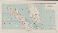
- "AMS 9101."
- Publisher:
- The Service,
- Subject (Geographic):
- Sumatera Selatan (Indonesia)--Maps
- Found in:
- Beinecke Rare Book and Manuscript Library > Sumatra (North) special strategic map / compiled by the Army Map Service.
- Creator:
- United States. Army Map Service
- Published / Created:
- [19]45.
- Call Number:
- 276GM 1945A
- Container / Volume:
- BRBL_00023C
- Image Count:
- 1
- Resource Type:
- Maps, Atlases & Globes
- Alternative Title:
- Series (Standard map series designation system) ; 9101.
- Description:
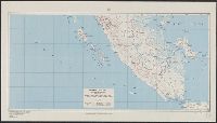
- "AMS 9101."
- Publisher:
- The Service,
- Subject (Geographic):
- Sumatera Selatan (Indonesia)--Maps
- Found in:
- Beinecke Rare Book and Manuscript Library > Sumatra (South) special strategic map / compiled by the Army Map Service.
- Creator:
- United States. Army Map Service
- Published / Created:
- 1944
- Call Number:
- 575 Su75 1944
- Container / Volume:
- BRBL_00312
- Image Count:
- 1
- Resource Type:
- Maps, Atlases & Globes
- Alternative Title:
- Its A.M.S. ; L991 and Series (Standard map series designation system) ; S6201.
- Description:
- "Approximate contour interval 10 meters."
- Publisher:
- Army Map Service,
- Subject (Geographic):
- Su-ao (Taiwan)--Maps
- Found in:
- Beinecke Rare Book and Manuscript Library > Suo / prepared under the direction of the Chief of Engineers by the Army Map Service.
- Creator:
- United States. Army Map Service
- Published / Created:
- [19]45.
- Call Number:
- 345gm 1945A
- Container / Volume:
- BRBL_00097
- Image Count:
- 1
- Resource Type:
- Maps, Atlases & Globes
- Alternative Title:
- A.M.S. ; 6201 and Series (Standard map series designation system) ; 6201.
- Description:
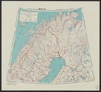
- Elevations are shown by hachures and spot heights in meters.
- Publisher:
- The Service,
- Subject (Topic):
- Transportation--Finland--Maps and Transportation--Sweden--Maps
- Found in:
- Beinecke Rare Book and Manuscript Library > Sweden and Finland (North) : special strategic map.
- Creator:
- United States. Army Map Service
- Published / Created:
- [19]45.
- Call Number:
- 345gm 1945B
- Container / Volume:
- BRBL_00097
- Image Count:
- 1
- Resource Type:
- Maps, Atlases & Globes
- Alternative Title:
- A.M.S. ; 6201 and Series (Standard map series designation system) ; 6201.
- Description:
- Elevations are shown by hachures and spot heights in meters.
- Publisher:
- The Service,
- Subject (Topic):
- Transportation--Finland--Maps and Transportation--Sweden--Maps
- Found in:
- Beinecke Rare Book and Manuscript Library > Sweden and Finland (South) : special strategic map.
- Creator:
- United States. Army Map Service
- Published / Created:
- 1945
- Call Number:
- 575 T14 1945
- Container / Volume:
- BRBL_00313
- Image Count:
- 1
- Resource Type:
- Maps, Atlases & Globes
- Alternative Title:
- Its A.M.S. ; L991 and Series (Standard map series designation system) ; L991.
- Description:
- "Contour interval 10 meters."
- Publisher:
- Army Map Service,
- Subject (Geographic):
- Takao-shū (Taiwan)--Maps
- Found in:
- Beinecke Rare Book and Manuscript Library > Takao, Takao-shu, Formosa (Taiwan) / prepared under the direction of the Chief of Engineers by the Army Map Service.
- Creator:
- United States. Army Map Service
- Published / Created:
- 1943
- Call Number:
- 212gmb 1943
- Container / Volume:
- BRBL_00015
- Image Count:
- 1
- Resource Type:
- Maps, Atlases & Globes
- Description:
- "Polyconic projection."
- Subject (Geographic):
- Azores--Maps
- Subject (Topic):
- Transportation--Azores--Maps
- Found in:
- Beinecke Rare Book and Manuscript Library > The Azores; special strategic map.
- Creator:
- United States. Army Map Service
- Published / Created:
- 1945
- Call Number:
- 33gm 1945
- Container / Volume:
- BRBL_00077
- Image Count:
- 1
- Resource Type:
- Maps, Atlases & Globes
- Alternative Title:
- Its A.M.S. 6201 and Series (Standard map series designation system) ; 6201.
- Description:
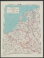
- "Lambert conformal conic projection."
- Subject (Topic):
- Transportation--Belgium--Maps, Transportation--Luxembourg--Maps, and Transportation--Netherlands--Maps
- Found in:
- Beinecke Rare Book and Manuscript Library > The Lowlands; special strategic map.
- Creator:
- United States. Army Map Service
- Published / Created:
- 1945
- Call Number:
- 2726gmb 1945
- Container / Volume:
- BRBL_00023B
- Image Count:
- 1
- Resource Type:
- Maps, Atlases & Globes
- Alternative Title:
- Its A.M.S. 9101 and Series (Standard map series designation system) ; 9101.
- Description:
- "Mercator projection."
- Publisher:
- The Service,
- Subject (Geographic):
- Timor Island--Maps
- Subject (Topic):
- Transportation--Timor Island--Maps
- Found in:
- Beinecke Rare Book and Manuscript Library > Timor, special strategic map.
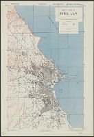
- Creator:
- United States. Army Map Service
- Published / Created:
- 1943
- Call Number:
- 675 M48 1943
- Container / Volume:
- BRBL_00349
- Image Count:
- 1
- Resource Type:
- Maps, Atlases & Globes
- Alternative Title:
- Geographical Section, General Staff ; no. 4241 and GSGS (Series) ; 4241.
- Description:
- "Compiled by Army Map Service, U. S. A. 1942. Revised ... by War Office, 1943."
- Publisher:
- Army Map Service,
- Subject (Geographic):
- Melilla (Spain)--Maps
- Found in:
- Beinecke Rare Book and Manuscript Library > Town plan of Melilla.