Skip to search
Skip to main content
Skip to first result
Search
You Searched For
Genre
Maps
Language
Latin
Creator
Visscher, Nicolaes, 1649-1702
Search Results
Creator:
Published / Created:
ca. 1684
Call Number:
Folio 469
Collection Title:
[Atlas factice of 13 maps by Nicolaes Visscher I, Nicolaes Visscher II, Guillaume Sanson, and
Image Count:
1
Publisher:
Nicolaes Visscher
Subject (Geographic):
Benelux countries --Maps --Early works to 1800 and Europe --Maps --Early works to 1800
Subject (Topic):
Atlases, Dutch --Early works to 1800
Collection Created:
1677-1692
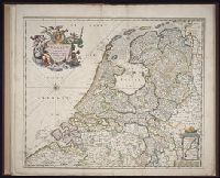
Found in:
Beinecke Rare Book and Manuscript Library > Belgium Foederatum / [cartographic material] / emendate auctum et novissime editum, per Nicolaum Visscher
Creator:
Published / Created:
ca. 1684
Call Number:
Folio 469
Collection Title:
[Atlas factice of 13 maps by Nicolaes Visscher I, Nicolaes Visscher II, Guillaume Sanson, and
Image Count:
1
Publisher:
Nicolaes Visscher
Subject (Geographic):
Europe --Maps --Early works to 1800 and Hainaut (Belgium) --Maps --Early works to 1800
Subject (Topic):
Atlases, Dutch --Early works to 1800
Collection Created:
1677-1692
Found in:
Beinecke Rare Book and Manuscript Library > Comitatus Hannoniae et Archiepiscopatus Cameracensis tabula / [cartographic material] / per Nicolaum Visscher
Creator:
Published / Created:
ca. 1684]
Call Number:
3371 1675
Container / Volume:
BRBL_00089
Image Count:
1
Resource Type:
Maps, Atlases & Globes
Description:
Bar scales given in "Milliaria Germanica communia" and "Milliaria Gallica communia"., Date inferred from C. Koeman's Atlantes Neerlandici, v. 3, p. 165 (Vis 10, map 7)., Prime meridian: Ferro., Relief shown pictorially., and Sheet measures 49.6 x 58.8
Publisher:
Nicolaes Visscher,
Subject (Geographic):
Hainaut (Belgium)--Maps--Early works to 1800
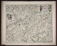
Found in:
Beinecke Rare Book and Manuscript Library > Comitatus Hannoniae et Archiepiscopatus Cameracensis tabula [cartographic material] / per Nicolaum Visscher.
Creator:
Published / Created:
ca. 1684
Call Number:
Folio 469
Collection Title:
[Atlas factice of 13 maps by Nicolaes Visscher I, Nicolaes Visscher II, Guillaume Sanson, and
Image Count:
1
Publisher:
Nicolaes Visscher
Subject (Geographic):
Europe --Maps --Early works to 1800 and Namur (County) --Maps --Early works to 1800
Subject (Topic):
Atlases, Dutch --Early works to 1800
Collection Created:
1677-1692
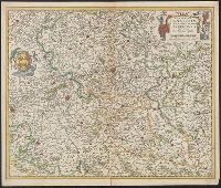
Found in:
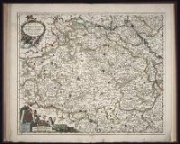
Beinecke Rare Book and Manuscript Library > Comitatus Namurci / [cartographic material] / emendata delineatio nuperrime in lucem edita per Nicolaum Visscher
Creator:
Published / Created:
ca. 1684
Call Number:
Folio 469
Collection Title:
[Atlas factice of 13 maps by Nicolaes Visscher I, Nicolaes Visscher II, Guillaume Sanson, and
Image Count:
2
Publisher:
Nicolaes Visscher
Subject (Geographic):
Europe --Maps --Early works to 1800 and Luxembourg --Maps --Early works to 1800
Subject (Topic):
Atlases, Dutch --Early works to 1800
Collection Created:
1677-1692
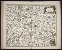
Found in:
Beinecke Rare Book and Manuscript Library > Ducatus Lutzenburgi novissima et accuratissima delineatio / [cartographic material] / per Nic. Visscher
Creator:
Published / Created:
ca. 1689]
Call Number:
1973 Folio 10
Image Count:
1
Description:
BEIN 1973 Folio 10: Sheet measures 61.2 x 52 cm. Bookplate of José M. Rodriguez. No. 7 of 63 maps bound together., BEIN 1981 Folio 7: Stamp of Albany Institute. No. 58 of 79 maps bound together., Relief shown pictorially., Shows grid, rivers and tributaries, lochs (shaded), trees, place and county names, settlements (symbols classified by importance in legend), territorial boundaries., Scale statement reads: "Milliaria Germanica Communia 15 in uno Gradu", with scale bar graded [0]-10; "Milliaria Scotica Communia quorum 50 in uno Gradu", with scale bar graded [0]-34; "Milliaria Gallica quae et Horae Itineris 20 in uno Gradu", with scale bar graded [0]-14., The four cardinal points are written in the borders., Features include ornate title cartouche (top left) with cherubs, male and female figures and royal coat-of-arms supported by lion and unicorn, arms of Scotland supported by cherubs (above scale cartouche at top right), compass indicator and coasts shaded outwards., "Bat. cum Privil. Ordin. Gener, Belgii Faederati"--Title cartouche., Shows Scotland including the Hebrides and Orkney islands., and In Latin with some place names in English; explanations and title for index to places in Dutch and English.
Publisher:
Nicolaes Visscher
Subject (Geographic):
Scotland
Found in:
Beinecke Rare Book and Manuscript Library > Exactissima Regni Scotiae tabula tam in septentrionalem et meriodionalem quam in minores earundem provincias, insulasq[ue], ei undique praetensas accurate divisa
Creator:
Published / Created:
1695?]
Call Number:
48 1695
Container / Volume:
BRBL_00262
Image Count:
1
Resource Type:
Maps, Atlases & Globes
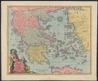
Description:
"Cum privil ... " and Pictorial cartouche.
Subject (Geographic):
Greece--Maps--Early works to 1800
Found in:
Beinecke Rare Book and Manuscript Library > Exactissima totius Archipelagi nec non Graeciae tabula : in qua omnes subjacentes regiones et insulae distincte ostenduntur / per Nicolaum Visscher, Amstelo-Batm.
Creator:
Published / Created:
ca. 1684
Call Number:
Folio 469
Collection Title:
[Atlas factice of 13 maps by Nicolaes Visscher I, Nicolaes Visscher II, Guillaume Sanson, and
Image Count:
1
Publisher:
Nicolaes Visscher
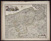
Subject (Geographic):
Belgium --Maps --Early works to 1800, Europe --Maps --Early works to 1800, and France, Northern --Maps --Early works to 1800
Subject (Topic):
Atlases, Dutch --Early works to 1800
Collection Created:
1677-1692
Found in:
Beinecke Rare Book and Manuscript Library > Flandriae comitatus / [cartographic material] / accuratissima descriptio edita per Nicolaum Visscher
Creator:
Published / Created:
ca. 1684
Call Number:
Folio 469
Collection Title:
[Atlas factice of 13 maps by Nicolaes Visscher I, Nicolaes Visscher II, Guillaume Sanson, and
Image Count:
1
Publisher:
Nicolaes Visscher
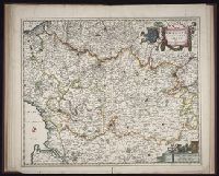
Subject (Geographic):
Artois (France) --Maps --Early works to 1800, Europe --Maps --Early works to 1800, and Pas-de-Calais (France) --Maps --Early works to 1800
Subject (Topic):
Atlases, Dutch --Early works to 1800
Found in:
Beinecke Rare Book and Manuscript Library > Geographica Artesiae comitatus tabula / [cartographic material] / per Nicolaum Visscher edita
Creator:
Published / Created:
1715?
Call Number:
1975 Folio 31
Collection Title:
[Atlas factice of 42 maps, produced by the Homann Erben firm]
Image Count:
1
Publisher:
Johann Baptist Homann
Subject (Geographic):
Ireland --Maps --Early works to 1800
Subject (Topic):
Atlases, German --Early works to 1800
Collection Created:
[Nuremberg,
Found in:
Beinecke Rare Book and Manuscript Library > Hiberniae regnum tam in praecipuas Ultoniae, Connaciae, Laceniae et Momoniae [cartographic material] : quam in minores earundem provincias et ditiones divisum ex prototype Guil. Petty-Vischeriano deductu et exhibitum / a Joh. Bapt. Homanno
Branch:v1.68.2 ,Deployed:2025-06-12T06:59:21-04:00