Western Australia. Department of Lands and Surveys
Published / Created:
1904
Call Number:
2651 1904
Container / Volume:
BRBL_00023
Image Count:
1
Resource Type:
Maps, Atlases & Globes
Description:
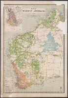
Inset: Map showing timber areas., Relief shown pictorially and by spot heights., and Shows "England and Wales on same scale as this map," "Lands held under Pastoral Lease," "Agricultural lands open for selection," and "Rainfall belts."
Publisher:
Dept. of Lands and Surveys,
Subject (Geographic):
Western Australia--Maps
Subject (Name):
Johnston, Harry F
Subject (Topic):
Land use, Rural--Australia--Western Australia--Maps