Skip to search
Skip to main content
Skip to first result
Search
You Searched For
Extent of Digitization
Completely digitized
Format
cartographic
Language
Latin
Search Results
Creator:
Published / Created:
1595]
Call Number:
212 A64 1595
Container / Volume:
BRBL_00014
Image Count:
1
Resource Type:
Maps, Atlases & Globes
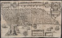
Description:
Bird's-eye-view.
Publisher:
s.n.,
Subject (Geographic):
Angra do Heroísmo (Azores)--Aerial views--Early works to 1800
Found in:
Beinecke Rare Book and Manuscript Library > A cidade de Angra na ilha de Iesu xpō da Tercera que esta em 39. graos. / auctor. Ioannes Hugonius a. Linschoten aō. 1595 ; Baptista à Doetechum, sculp.
Creator:
Published / Created:
172-?]
Call Number:
400 172X
Container / Volume:
BRBL_00232
Image Count:
1
Resource Type:
Maps, Atlases & Globes
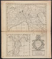
Description:
"Dedicated to His Highness William Duke of Glocester."
Publisher:
s.n.,
Subject (Geographic):
Italy--Historical geography--Maps--Early works to 1800, Italy--History--To 476--Maps--Early works to 1800, and Rome--Maps--Early works to 1800
Subject (Name):
Nicholls, Sutton and Wells, Edward, 1667-1727. New sett of maps both of antient and present geography
Found in:
Beinecke Rare Book and Manuscript Library > A new map of Gallia Cisalpina & Graecia Magna, shewing their cheif [sic] divisions, people, cities, towns &c. / Sutton Nicholls sculp.
Creator:
Published / Created:
172-?]
Call Number:
400 172XA
Container / Volume:
BRBL_00232
Image Count:
1
Resource Type:
Maps, Atlases & Globes
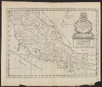
Description:
"Dedicated to His Highness William Duke of Glocester."
Publisher:
s.n.,
Subject (Geographic):
Italy--Historical geography--Maps--Early works to 1800, Italy--History--To 476--Maps--Early works to 1800, and Rome--Maps--Early works to 1800
Subject (Name):
Nicholls, Sutton and Wells, Edward, 1667-1727. New sett of maps both of antient and present geography
Found in:
Beinecke Rare Book and Manuscript Library > A new map of Latium, Etruria, and as much of antient Italy as lay between Gallia Cisalpina and Graecia Magna, shewing their principal divisions, cities, towns, rivers, mountains, &c. / Sutton Nicholls sculp.
Creator:
Published / Created:
172-?]
Call Number:
400 172XB
Container / Volume:
BRBL_00232
Image Count:
1
Resource Type:
Maps, Atlases & Globes
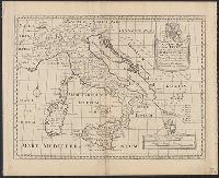
Description:
"Dedicated to His Highness William Duke of Glocester."
Publisher:
s.n.,
Subject (Geographic):
Italy--Historical geography--Maps--Early works to 1800, Italy--History--To 476--Maps--Early works to 1800, and Rome--Maps--Early works to 1800
Subject (Name):
Nicholls, Sutton and Wells, Edward, 1667-1727. New sett of maps both of antient and present geography
Found in:
Beinecke Rare Book and Manuscript Library > A new map of antient Italy : together with the adjoyning islands of Sicily, Sardinia, and Corsica, shewing their principal divisions, cities, towns, rivers, mountains &c. / Sutton Nicholls sculp.
Creator:
Published / Created:
[1701]
Call Number:
3190 No. 2
Collection Title:
New sett of maps both of antient and present geography ...
Container / Volume:
BRBL_00041
Image Count:
1
Resource Type:
Maps, Atlases & Globes
Alternative Title:
New map of the British Isles, showing their ancient people, cities and towns of note in the time of the Romans
Description:
"Sutton Nicholls sculp."
Publisher:
[Edward Wells],
Subject (Geographic):
British Isles--Maps and Europe--British Isles
Subject (Name):
Nicholls, Sutton
Found in:
Beinecke Rare Book and Manuscript Library > A new map of the Brittish Isles : shewing their antient people, cities and towns of note, in the time of the Romans.
Published / Created:
[1630?]
Call Number:
363 1630A
Container / Volume:
BRBL_00141
Image Count:
2
Resource Type:
Maps, Atlases & Globes
Publisher:
Sumptibus Henrici Hondy,
Subject (Geographic):
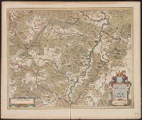
Hesse (Germany)--Maps--Early works to 1800
Found in:
Beinecke Rare Book and Manuscript Library > Abbatia Heresfeldensis ... Hirsfeldt.
Creator:
Published / Created:
[1625]
Call Number:
BrSides Box 2019 15
Image Count:
2
Resource Type:
Maps, Atlases & Globes
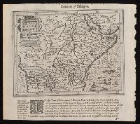
Description:
Relief shown pictorially.
Publisher:
[Printed by William Stansby for Henrie Fetherstone],
Subject (Geographic):
Africa, Central--Maps--Early works to 1800.
Subject (Name):
Featherstone, Henry, -1647, bookseller., Purchas, Samuel, 1577?-1626. Purchas his Pilgrimage. 1625., and Stansby, William, active 1597-1638, printer.
Found in:
Beinecke Rare Book and Manuscript Library > Abissinorum Regnu[m].
Creator:
Published / Created:
1595]
Call Number:
51 1595A
Container / Volume:
BRBL_00278
Image Count:
2
Resource Type:
Maps, Atlases & Globes
Description:
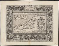
"Privilegio Imperiali, Regio, et Belgico decennali, 1586."
Publisher:
Officina Plantiniana,
Subject (Geographic):
Palestine--History--Maps--Early works to 1800
Subject (Name):
Abraham--(Biblical patriarch), Abraham--(Biblical patriarch)--Travel--Maps--Early works to 1800, Moflinius, Iohannes, and Ortelius, Abraham, 1527-1598. Theatrum orbis terrarum
Subject (Topic):
Bible--Geography--Maps--Early works to 1800
Found in:
Beinecke Rare Book and Manuscript Library > Abrahami patriarchae peregrinatio, et vita / Abrahamo Ortelio Antverpiano auctore.
Creator:
Call Number:
40 Ab88 1609
Container / Volume:
BRBL_00203
Image Count:
2
Resource Type:
Maps, Atlases & Globes
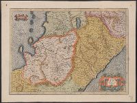
Description:
"Cum privilegio".
Subject (Geographic):
Abruzzo (Italy)--Maps--Early works to 1800 and Campania (Italy)--Maps--Early works to 1800
Subject (Name):
Hondius, Jodocus, 1563-1612
Found in:
Beinecke Rare Book and Manuscript Library > Abruzzo et Terra di Lavoro / per Gerardum Mercatorem.
Creator:
Published / Created:
[between 1613 and 1619]
Call Number:
4069 1620
Container / Volume:
BRBL_00237
Image Count:
2
Resource Type:
Maps, Atlases & Globes
Description:
"Cum privilegio".
Publisher:
[publisher not identified],
Subject (Geographic):
Abruzzo (Italy)--Maps--Early works to 1800 and Campania (Italy)--Maps--Early works to 1800
Found in:
Beinecke Rare Book and Manuscript Library > Abruzzo et Terra di Lavoro / per Gerardum Mercatorem.