Skip to search
Skip to main content
Skip to first result
Search
You Searched For
Extent of Digitization
Completely digitized
Format
cartographic
Search Results
Published / Created:
[1795]
Call Number:
801 1795
Container / Volume:
BRBL_00541
Image Count:
1
Resource Type:
Maps, Atlases & Globes
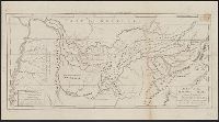
Description:
Engraved for Carey's American Edition of Guthrie's Geography Improved.
Subject (Geographic):
Tennessee--Maps--Early works to 1800
Found in:
Beinecke Rare Book and Manuscript Library > A Map of the Tennassee State formerly Part of North Carolina taken Chiefly from Survey by Genl. Smith & others.
Published / Created:
[1831?]
Call Number:
764 B63 1831
Container / Volume:
BRBL_00454
Image Count:
1
Resource Type:
Maps, Atlases & Globes
Publisher:
Pendleton Lithography,
Subject (Geographic):
Bolton (Mass. : Town)--Maps
Found in:
Beinecke Rare Book and Manuscript Library > A Map of the Town of Bolton in the County of Worcester and the Commonwealth of Massachusetts. Surveyed by Silas Holman in the Year 1831.
Published / Created:
1828
Call Number:
75 1828D
Container / Volume:
BRBL_00709
Image Count:
1
Resource Type:
Maps, Atlases & Globes
Description:
Color: pen and ink drawing; blue, green, purple, yellow and orange.
Subject (Geographic):
United States--Maps, Manuscript
Found in:
Beinecke Rare Book and Manuscript Library > A Map of the United States. Projected by Nancy Gibbs, Livermore, 1828.
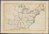
Published / Created:
1809
Call Number:
755 1809A
Container / Volume:
BRBL_00438
Image Count:
1
Resource Type:
Maps, Atlases & Globes
Description:
Inset: Florida.
Publisher:
Engraved for and sold by Matthew Carey,
Subject (Geographic):
Canada--Maps and East (U.S.)--Maps
Found in:
Beinecke Rare Book and Manuscript Library > A Map of the United States: compiled chiefly from the State Maps, and other Authentic Information, by Saml. Lewis.
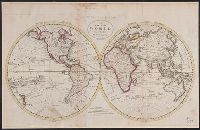
Published / Created:
1795
Call Number:
11 1795
Container / Volume:
BRBL_00006
Image Count:
1
Resource Type:
Maps, Atlases & Globes
Description:
From Carey's American Edition of Guthrie's Geography Improved.
Publisher:
Mathew Carey,
Subject (Geographic):
World--Maps--Early works to 1800
Found in:
Beinecke Rare Book and Manuscript Library > A Map of the World from the best Authorities.
Published / Created:
1757
Call Number:
36hc P88 1756
Container / Volume:
BRBL_00134
Image Count:
1
Resource Type:
Maps, Atlases & Globes
Alternative Title:
Plan of the city of Prague ...
Description:
Includes "Extract from several Authentic Letters from Berlin, giving an Account of the Battle fought between the Prussians and Austrians near Prague, May 6, 1757."
Publisher:
T. Jefferys,
Subject (Geographic):
Germany--Maps--Early works to 1800
Found in:
Beinecke Rare Book and Manuscript Library > A Map of the country round Prague ... : A Plan of the city of Prague ...
Published / Created:
[1774]
Call Number:
76 1774
Container / Volume:
BRBL_00729
Image Count:
1
Resource Type:
Maps, Atlases & Globes
Abstract:
Subject: Map of New England and Long Island with the states divided into cities and towns. Cartouche at lower right shows Liberty leading a Native American and pilgrims to Plymouth Rock.
Description:
"Observations on which this map is grounded."
Publisher:
November 29th 1774 Published according to Act by Thos. Jefferys geographer to His Royal Highness the Prince of Wales near Charing Cross,
Subject (Geographic):
Boston Harbor (Mass.)--Maps and New England--Maps
Subject (Name):
Jefferys, Thomas, -1771, publisher
Found in:
Beinecke Rare Book and Manuscript Library > A Map of the most inhabited part of New England [cartographic material] : containing the provinces of Massachusets Bay and New Hampshire with the colonies of Conecticut and Rhode Island divided into counties and townships : The whole composed from actual
Published / Created:
[1774]
Call Number:
76 1774
Container / Volume:
BRBL_00729
Image Count:
2
Resource Type:
Maps, Atlases & Globes
Abstract:
Subject: Map of New England and Long Island with the states divided into cities and towns. Cartouche at lower right shows Liberty leading a Native American and pilgrims to Plymouth Rock.
Description:
"Observations on which this map is grounded."
Publisher:
November 29th 1774 Published according to Act by Thos. Jefferys geographer to His Royal Highness the Prince of Wales near Charing Cross,
Subject (Geographic):
Boston Harbor (Mass.)--Maps and New England--Maps
Subject (Name):
Jefferys, Thomas, -1771, publisher
Found in:
Beinecke Rare Book and Manuscript Library > A Map of the most inhabited part of New England [cartographic material] : containing the provinces of Massachusets Bay and New Hampshire with the colonies of Conecticut and Rhode Island divided into counties and townships : The whole composed from actual
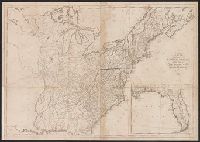
Published / Created:
[1774]
Call Number:
76 1774
Container / Volume:
BRBL_00443
Image Count:
2
Resource Type:
Maps, Atlases & Globes
Abstract:
Subject: Map of New England and Long Island with the states divided into cities and towns. Cartouche at lower right shows Liberty leading a Native American and pilgrims to Plymouth Rock.
Description:
"Observations on which this map is grounded."
Publisher:
November 29th 1774 Published according to Act by Thos. Jefferys geographer to His Royal Highness the Prince of Wales near Charing Cross,
Subject (Geographic):
Boston Harbor (Mass.)--Maps and New England--Maps
Subject (Name):
Jefferys, Thomas, -1771, publisher
Found in:
Beinecke Rare Book and Manuscript Library > A Map of the most inhabited part of New England [cartographic material] : containing the provinces of Massachusets Bay and New Hampshire with the colonies of Conecticut and Rhode Island divided into counties and townships : The whole composed from actual
Branch:v1.68.6 ,Deployed:2025-07-02T08:09:34-04:00