Search
You Searched For
Search Results
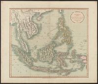
- Published / Created:
- 1811
- Call Number:
- 27 1811
- Container / Volume:
- BRBL_00023A
- Image Count:
- 1
- Resource Type:
- Maps, Atlases & Globes
- Description:
- Preliminary record.
- Publisher:
- J. Cary,
- Subject (Geographic):
- Indonesia--Maps
- Found in:
- Beinecke Rare Book and Manuscript Library > A New Map of the East India Isles ... John Cary, Engraver.
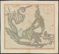
- Published / Created:
- 1801
- Call Number:
- 27 1801
- Container / Volume:
- BRBL_00023A
- Image Count:
- 1
- Resource Type:
- Maps, Atlases & Globes
- Description:
- Preliminary record.
- Subject (Geographic):
- Indonesia--Maps
- Found in:
- Beinecke Rare Book and Manuscript Library > A New Map of the East India Isles. From the Latest Authorities. By John Cary, Engraver.
- Published / Created:
- 1701
- Call Number:
- 501 1701
- Container / Volume:
- BRBL_00275
- Image Count:
- 1
- Resource Type:
- Maps, Atlases & Globes
- Publisher:
- Edward Wells,
- Subject (Geographic):
- Turkey--Maps--Early works to 1800
- Found in:
- Beinecke Rare Book and Manuscript Library > A New Map of the Eastern Parts of Asia Minor ...
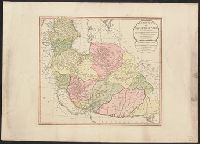
- Published / Created:
- 1794
- Call Number:
- 534 1794
- Container / Volume:
- BRBL_00289
- Image Count:
- 1
- Resource Type:
- Maps, Atlases & Globes
- Description:
- Copy 2 is colored and in good condition.
- Publisher:
- Laurie & Whittle,
- Subject (Geographic):
- Iran--Maps--Early works to 1800
- Found in:
- Beinecke Rare Book and Manuscript Library > A New Map of the Empire of Persia from Monsr. DAnville ... with several Additions and Emendations.
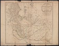
- Published / Created:
- 1794
- Call Number:
- 534 1794
- Container / Volume:
- BRBL_00289
- Image Count:
- 1
- Resource Type:
- Maps, Atlases & Globes
- Publisher:
- Laurie & Whittle,
- Subject (Geographic):
- Iran--Maps--Early works to 1800
- Found in:
- Beinecke Rare Book and Manuscript Library > A New Map of the Empire of Persia from Monsr. DAnville ... with several Additions and Emendations.
- Published / Created:
- 1701]
- Call Number:
- 51 1701
- Container / Volume:
- BRBL_00278
- Image Count:
- 1
- Resource Type:
- Maps, Atlases & Globes
- Publisher:
- Edward Wells,
- Subject (Geographic):
- Palestine--Maps--Early works to 1800
- Found in:
- Beinecke Rare Book and Manuscript Library > A New Map of the Land of Canaan ...
- Published / Created:
- [1749?]
- Call Number:
- 7855 1749
- Container / Volume:
- BRBL_00515
- Image Count:
- 1
- Resource Type:
- Maps, Atlases & Globes
- Description:
- From The English pilot, The Fourth book. Dublin, Geo. Grierson, 1749 and later and perhaps earlier editions. Copied from the London wdition.
- Subject (Geographic):
- North Carolina--Maps--Early works to 1800 and South Carolina--Maps--Early works to 1800
- Found in:
- Beinecke Rare Book and Manuscript Library > A New Mapp of Carolina By John Thornton at ye Platt in ye Minories And Will: Fisher at ye Postorn Gate on Towerhill, London.
- Published / Created:
- [ca. 1789]
- Call Number:
- 6555cea 1789
- Container / Volume:
- BRBL_00708
- Image Count:
- 3
- Resource Type:
- Maps, Atlases & Globes
- Description:
- A plan of the Cove at Bassa with the adjacent roads.
- Publisher:
- Robert Sayer,
- Subject (Geographic):
- Ghana--Maps, Manuscript--Early works to 1800
- Found in:
- Beinecke Rare Book and Manuscript Library > A New Survey of that part of the Coast of Africa comprised between Cape Verga and Cape Formoso, including chiefly the Windward and Gold Coasts in which the Latitudes of all the Principal Places are determined by Actual observations, the bearings and cours
- Published / Created:
- 1770?]
- Call Number:
- 501 1770
- Container / Volume:
- BRBL_00275
- Image Count:
- 1
- Resource Type:
- Maps, Atlases & Globes
- Subject (Geographic):
- Turkey--Maps--Early works to 1800
- Found in:
- Beinecke Rare Book and Manuscript Library > A New and Accurate Map of Anatolia or Asia Minor with Syria and such other Provinces of the Turkish Empire as border thereupon ... By Eman. Bowen.
- Published / Created:
- 1794
- Call Number:
- 755cea 1794
- Container / Volume:
- BRBL_00441
- Image Count:
- 4
- Resource Type:
- Maps, Atlases & Globes
- Description:
- From the North American pilot. A new ed. much enlarged of the second part of the North Am. Pilot. fol. London, R. Laurie & J. Whittle, 1800.
- Publisher:
- Laurie & Whittle,
- Subject (Geographic):
- Canada--Maps--Early works to 1800 and East (U.S.)--Maps--Early works to 1800
- Found in:
- Beinecke Rare Book and Manuscript Library > A New and Correct Chart of the Coast of New England and New York with the adjacent parts of Nova Scotia and New Brunswick from Cape Sable to the entrance of Hudsons or North River by Captain Holland.