Search
You Searched For
Search Results
- Published / Created:
- [1764?]
- Call Number:
- 76cea 1764
- Container / Volume:
- BRBL_00446
- Image Count:
- 1
- Resource Type:
- Maps, Atlases & Globes
- Description:
- From the English Pilot, the Fourth Book, London, W.&I. Mount, T. Page, 1764 and later editions.
- Publisher:
- W.&I. Mount & T. Page,
- Subject (Geographic):
- New England--Maps--Early works to 1800
- Found in:
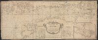
- Beinecke Rare Book and Manuscript Library > A New and Correct Chart of the Sea Coast of New-England, from Cape Codd to Casco Bay. Lately Surbey'd by Capt. Henry Barnsley.
- Published / Created:
- 1794
- Call Number:
- 303cea 1794
- Container / Volume:
- BRBL_00033
- Image Count:
- 1
- Resource Type:
- Maps, Atlases & Globes
- Description:
- Aspo Is. & Harbor: 1:15,000.
- Publisher:
- Laurie & Whittle,
- Subject (Geographic):
- Baltic Sea--Maps--Early works to 1800
- Found in:
- Beinecke Rare Book and Manuscript Library > A New and Correct chart of the Gulf of Finland ... Published by command of the Empress of all the Russias.
- Published / Created:
- 1743
- Call Number:
- 319 1743
- Container / Volume:
- BRBL_00040
- Image Count:
- 1
- Resource Type:
- Maps, Atlases & Globes
- Description:
- Preliminary record.
- Publisher:
- Henry Overton,
- Subject (Geographic):
- British Isles--Maps--Early works to 1800
- Found in:
- Beinecke Rare Book and Manuscript Library > A New and exact map of Great Britain ... [Including Ireland].
- Published / Created:
- 1811
- Call Number:
- 319 1811
- Container / Volume:
- BRBL_00040
- Image Count:
- 1
- Resource Type:
- Maps, Atlases & Globes
- Description:
- Preliminary record.
- Publisher:
- J. Cary,
- Subject (Geographic):
- British Isles--Maps
- Found in:
- Beinecke Rare Book and Manuscript Library > A New map of the British Isles ... By John Cary, Engraver.
- Published / Created:
- 1793
- Call Number:
- 304gmd 1793
- Container / Volume:
- BRBL_00034B
- Image Count:
- 1
- Resource Type:
- Maps, Atlases & Globes
- Description:
- Preliminary record.
- Publisher:
- Robert Sayer,
- Subject (Geographic):
- Europe,Central--Maps--Early works to 1800
- Found in:
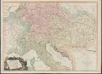
- Beinecke Rare Book and Manuscript Library > A New map of the Emperor's Dominions exhibiting the Post Roads of Germany, Hungary, and the Netherlands ... parts of France, Italy, Switzerland and Poland ...
- Published / Created:
- 1711
- Call Number:
- 764 B65 1711
- Container / Volume:
- BRBL_00710
- Image Count:
- 1
- Resource Type:
- Maps, Atlases & Globes
- Description:
- Color: ink and yellow.
- Subject (Geographic):
- Boston (Mass.)--Maps--Early works to 1800
- Found in:
- Beinecke Rare Book and Manuscript Library > A New plan of the Harbour of Boston in New England. Lat. 42, 29 North. Long. 71 West. Surveyed by Order of the Commissioners of her Majesty's Navy.
- Published / Created:
- 1790
- Call Number:
- 755 1790A
- Container / Volume:
- BRBL_00435
- Image Count:
- 1
- Resource Type:
- Maps, Atlases & Globes
- Subject (Geographic):
- Canada--Maps--Early works to 1800 and East (U.S.)--Maps--Early works to 1800
- Found in:
- Beinecke Rare Book and Manuscript Library > A Particular Map of the American Lakes, Rivers, &c. Par le Sr. D'Anville. Drawn & Engraved for John Harrison.
- Published / Created:
- 1828
- Call Number:
- 38GMD 1828
- Container / Volume:
- BRBL_00171
- Image Count:
- 1
- Resource Type:
- Maps, Atlases & Globes
- Description:
- Inset: Corsica.
- Publisher:
- C. Smith,
- Subject (Geographic):
- France--Maps
- Found in:
- Beinecke Rare Book and Manuscript Library > A Physical and Topographical map of France ... the post Roads & Relays ... inland Navigation &c. Pickett Sculp. J. Smith Delin.
- Published / Created:
- 1776
- Call Number:
- 792cea Am32 1776
- Container / Volume:
- BRBL_00519
- Image Count:
- 1
- Resource Type:
- Maps, Atlases & Globes
- Description:
- From the North American Pilot 1783.
- Publisher:
- R. Sayer & J. Bennett,
- Subject (Geographic):
- Florida--Maps--Early works to 1800
- Found in:
- Beinecke Rare Book and Manuscript Library > A Plan of Amelia Harbour and Barr in east Florida ...
- Published / Created:
- [1790]
- Call Number:
- 785cea C17 1790
- Container / Volume:
- BRBL_00715
- Image Count:
- 1
- Resource Type:
- Maps, Atlases & Globes
- Description:
- Color: pen and ink drawing.
- Subject (Geographic):
- North Carolina--Maps, Manuscript--Early works to 1800
- Found in:
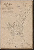
- Beinecke Rare Book and Manuscript Library > A Plan of Cape Fear River from the Bar to Brunswick. [By Robert Sayer].