Search
You Searched For
Search Results
- Published / Created:
- [1725?]
- Call Number:
- 491 IS7 1725
- Container / Volume:
- BRBL_00270
- Image Count:
- 1
- Resource Type:
- Maps, Atlases & Globes
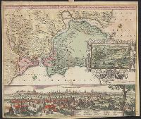
- Description:
- Insets: View of Constantinople with index, view through the Dardanelles to Constantinople.
- Publisher:
- Johann Baptist Homann ... ,
- Subject (Geographic):
- Thrace, Eastern (Turkey)--Maps--Early works to 1800
- Found in:
- Beinecke Rare Book and Manuscript Library > Accurate Vorstellung der Orientalish-Kayserlichen Haupt-und Residenz-Stadt Constantinople ... Meer-Engen, Bosphoro Thracio, und Hellesponto ...
- Creator:
- Visscher, Claes Jansz., 1586 or 1587-1652
- Published / Created:
- [1667]
- Call Number:
- 321 1667
- Container / Volume:
- BRBL_00054A
- Image Count:
- 1
- Resource Type:
- Maps, Atlases & Globes
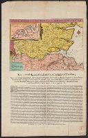
- Alternative Title:
- Kaerte van de rivieren van London en Rochester of Chetham
- Description:
- Includes inset of Medway River below Rochester, ill., and text.
- Publisher:
- Nicolaes Visscher, in de Kalverstraet, in de Visscher,
- Subject (Geographic):
- Medway, River (England)--Maps--Early works to 1800 and Thames Valley (England)--Maps--Early works to 1800
- Subject (Name):
- Ruyter, Michiel Adriaanszoon de,--1607-1676
- Subject (Topic):
- Anglo-Dutch War, 1664-1667--Naval operations
- Found in:
- Beinecke Rare Book and Manuscript Library > Afbeeldinge vande rivieren van London en Rochester.
- Creator:
- Vinckeboons, Joan
- Published / Created:
- [1925?]
- Call Number:
- 582 J987 1665
- Container / Volume:
- BRBL_00314
- Image Count:
- 1
- Resource Type:
- Maps, Atlases & Globes
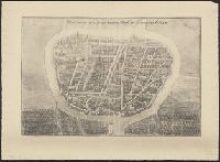
- Description:
- From: Monumenta cartographica I. 18.
- Publisher:
- [Martinus Nijhoff],
- Subject (Geographic):
- Phra Nakhon Si Ayutthaya (Thailand)--Maps.
- Subject (Name):
- Wieder, F. C. (Frederik Caspar), 1874-1943. Monumenta cartographica.
- Found in:
- Beinecke Rare Book and Manuscript Library > Afbeldinge der Stadt Iudiad hooft des choonincrick Siam.
- Creator:
- Jansson, Jan, 1588-1664
- Published / Created:
- [between 1641 and 1658?]
- Call Number:
- 70 165X
- Container / Volume:
- BRBL_00353
- Image Count:
- 2
- Resource Type:
- Maps, Atlases & Globes
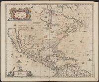
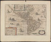
- Description:
- Covers North America, Cent
- Publisher:
- excudit Ioannes Ianssonius,
- Subject (Geographic):
- North America--Maps--Early works to 1800
- Subject (Name):
- Jansson, Jan, 1588-1664. Atlas novus. Dutch
- Found in:
- Beinecke Rare Book and Manuscript Library > America Septentrionalis.
- Creator:
- Jansson, Jan, 1588-1664
- Published / Created:
- [1652?]
- Call Number:
- 70 165XA
- Container / Volume:
- BRBL_00353
- Image Count:
- 2
- Resource Type:
- Maps, Atlases & Globes
- Description:
- Appears in various eds. of Jansson's Nieuwen atlas.
- Publisher:
- Excudit Ioannes Ianssonius,
- Subject (Geographic):
- America--Maps--Early works to 1800
- Subject (Name):
- Jansson, Jan, 1588-1664. Atlas novus. Dutch
- Found in:
- Beinecke Rare Book and Manuscript Library > America noviter delineata.
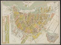
- Creator:
- Braakensiek, A., sr., 1811-1883
- Published / Created:
- 1880
- Call Number:
- 331 Am88 1880
- Container / Volume:
- BRBL_00079
- Image Count:
- 2
- Resource Type:
- Maps, Atlases & Globes
- Alternative Title:
- Platte grond van Amsterdam in 1880
- Description:
- Inzet: [1.] Vondels park ; [2.] Plan van uitbreiding der stad, vastgesteld in 1874.
- Publisher:
- Funke,
- Subject (Geographic):
- Amsterdam (Netherlands)--Maps
- Found in:
- Beinecke Rare Book and Manuscript Library > Amsterdam in 1880 / A. Braakensiek, fec.
- Creator:
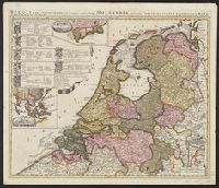
- Schenk, Peter, 1660-1718 or 1719
- Published / Created:
- 1700?]
- Call Number:
- 331 1700A
- Container / Volume:
- BRBL_00078
- Image Count:
- 1
- Resource Type:
- Maps, Atlases & Globes
- Description:
- "Cum privil."
- Publisher:
- Peter Schenk?
- Subject (Geographic):
- East Indies--Maps--Early works to 1800, Netherlands--Maps--Early works to 1800, and New Netherland--Maps--Early works to 1800
- Found in:
- Beinecke Rare Book and Manuscript Library > Belgii pars septentrionalis communi nomine vulgo Hollandia : nuncupata continens statum potentissimae Batavorum Reipublicae seu Provincias VII. foederatas. Cum omnium provinciarum insignibus, additis omnibus nominibus urbium et pagorum edente / Petro Sche
- Published / Created:
- 1635
- Call Number:
- 3331 Sc28 1635
- Container / Volume:
- BRBL_00082
- Image Count:
- 1
- Resource Type:
- Maps, Atlases & Globes
- Description:
- Preliminary record.
- Subject (Geographic):
- North Holland (Netherlands)--Maps--Early works to 1800
- Found in:
- Beinecke Rare Book and Manuscript Library > Caerte van de Scher-meer...1635...
- Published / Created:
- 1640
- Call Number:
- 3333 Sc26 1640
- Container / Volume:
- BRBL_00084
- Image Count:
- 1
- Resource Type:
- Maps, Atlases & Globes
- Description:
- Preliminary record.
- Subject (Geographic):
- Scheldt River--Maps--Early works to 1800 and Zeeland (Netherlands : Province)--Maps--Early works to 1800
- Found in:
- Beinecke Rare Book and Manuscript Library > Caerte vant Scheldt ende Santvliet ... / door Claes Ianβ Visscher.
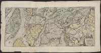
- Creator:
- Homann Erben (Firm)
Homann, Johann Baptist, 1663-1724
- Published / Created:
- 1743
- Call Number:
- 1975 Folio 31
- Collection Title:
- [Atlas factice of 42 maps, produced by the Homann Erben firm]
- Image Count:
- 1
- Alternative Title:
- Staat von der Republic Genova, nach seiner Eintheilung in die ost- u. west-Revier
- Publisher:
- Homann Erben
- Subject (Geographic):
- Genoa (Italy) --Maps --Early works to 1800
- Subject (Topic):
- Atlases, German --Early works to 1800
- Collection Created:
- [Nuremberg,
- Found in:
- Beinecke Rare Book and Manuscript Library > Carta Geographica, la quale rappresenta lo Stato della Republica di Genova partita nella Riviera di Levante et di Ponente / [cartographic material] / data in publico per gli Heredi d'Homann ; con privil. imp le 1743 = Staat von der Republic Genova, nach s