Skip to search
Skip to main content
Skip to first result
Search
You Searched For
Extent of Digitization
Completely digitized
Genre
Maps
Language
English
Search Results
Creator:
Published / Created:
1943.
Call Number:
36gma 1943
Image Count:
1
Description:
"Map no. 1994, 25 August 1943."
Publisher:
Lithographed in the Reproduction Branch, OSS
Subject (Geographic):
Europe, Central and Germany
Subject (Topic):
Inland navigation and Maps
Found in:
Beinecke Rare Book and Manuscript Library > "Greater Germany" inland waterways
Creator:
Published / Created:
1945.
Call Number:
36cb 1945
Image Count:
1
Description:
Shows cave regions within the "Greater" German boundary of 1944.
Publisher:
OSS
Subject (Geographic):
Europe, Central
Subject (Topic):
Caves
Found in:
Beinecke Rare Book and Manuscript Library > "Greater" Germany caves and cave regions
Creator:
Published / Created:
1945.
Call Number:
36eb 1945B
Image Count:
1
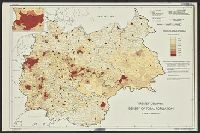
Description:
"No. 6381-R & A, OSS, 28 April 1945."
Publisher:
R & A, OSS
Subject (Geographic):
Germany and Europe, Central
Subject (Topic):
Population and Maps
Found in:
Beinecke Rare Book and Manuscript Library > "Greater" Germany, density of total population by Kreise or similar units excluding cities 10,000 and over
Creator:
Published / Created:
1945
Call Number:
36eb 1945C
Container / Volume:
BRBL_00127
Image Count:
1
Resource Type:
Maps, Atlases & Globes
Description:
"No. 6380 - R & A, OSS, 28 April 1945."
Publisher:
R & A, OSS,
Subject (Geographic):
Europe, Central--Population--Maps and Germany--Population--Maps
Found in:
Beinecke Rare Book and Manuscript Library > "Greater" Germany, density of total population by Kreise or similar units.
Creator:
Published / Created:
1945
Call Number:
36eb 1939A
Container / Volume:
BRBL_00127
Image Count:
1
Resource Type:
Maps, Atlases & Globes
Description:
"No. 6356, R.A., OSS, 10 April 1945."
Publisher:
R & A, OSS,
Subject (Geographic):
Europe, Central--Maps and Germany--Maps
Subject (Topic):
Working class--Europe, Central--Maps and Working class--Germany--Maps
Found in:
Beinecke Rare Book and Manuscript Library > "Greater" Germany, population dependent upon commercial and service occupations (by Kreise 1939).
Creator:
Published / Created:
1945
Call Number:
36eb 1945A
Container / Volume:
BRBL_00127
Image Count:
1
Resource Type:
Maps, Atlases & Globes
Description:
"No. 7113--R & A, IRIS 31 October 1945."
Publisher:
The Branch,
Subject (Geographic):
Germany--Maps and Germany--Population--Maps
Found in:
Beinecke Rare Book and Manuscript Library > "Greater" Germany. : population change by Kreise, circa 1933-1939.
Creator:
Published / Created:
1945
Call Number:
36eb 1939
Container / Volume:
BRBL_00127
Image Count:
1
Resource Type:
Maps, Atlases & Globes
Description:
"No. 6357 - R & A, OSS, 10 April 1945."
Publisher:
R & A, OSS,
Subject (Geographic):
Europe, Central--Population--Maps and Germany--Population--Maps
Found in:
Beinecke Rare Book and Manuscript Library > "Greater" Germany; population dependent upon agriculture (by kreise, 1939)
Published / Created:
[1944?]
Call Number:
307hc 1944
Container / Volume:
BRBL_00036A
Image Count:
1
Resource Type:
Maps, Atlases & Globes
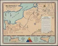
Description:
Inset: North African and Sicilian campaigns.
Publisher:
G-2 Section, 2nd A.D.,
Subject (Geographic):
Europe, Western--Maps
Found in:
Beinecke Rare Book and Manuscript Library > "Hell on Wheels" 1942-1943-1944.
Published / Created:
[1874?]
Call Number:
796gme 1874
Container / Volume:
BRBL_00531
Image Count:
2
Resource Type:
Maps, Atlases & Globes
Alternative Title:
Proposed lines of the International R.R. of Mexico., Railroad map of Texas, Texas New Yorker., Texas New Yorker's map of the United States., and Travelers' and immigrants' guide, or railroad map to Texas
Description:
"Entered according to act of Congress in the year 1874 by Geo. H. Sweet in the office of the Librarian of Congress at Washington."
Publisher:
Geo. H. Sweet,
Subject (Name):
Streeter, Thomas W.--(Thomas Winthrop),--1883-1965--Ownership and Sweet, George H
Subject (Topic):
Railroads--Mexico--Maps, Railroads--Texas--Maps, and Railroads--United States--Maps
Found in:
Beinecke Rare Book and Manuscript Library > "Texas New Yorker's" railroad map of Texas : showing all completed and proposed routes, with principal rivers, county boundaries and county-seats, railroad stations and distances, congressional districts, United States military telegraph line, and frontie
Branch:v1.68.6 ,Deployed:2025-07-02T08:09:21-04:00