Search
You Searched For
Search Results
- Published / Created:
- 1760
- Call Number:
- 771fcm R297 1760
- Container / Volume:
- BRBL_00714
- Image Count:
- 1
- Resource Type:
- Maps, Atlases & Globes
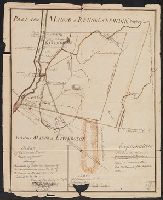
- Description:
- Color: pen and ink with green detail.
- Subject (Geographic):
- New York--Maps, Manuscript--Early works to 1800
- Found in:
- Beinecke Rare Book and Manuscript Library > A Map Claverack and Parts adjacent shewing the Claim of John Van Renselaer Esqr. The construction set up on the part of the crown, in the late action of intrustion. Done at New York, 9. Nov. 1760.
- Published / Created:
- 19--?]
- Call Number:
- 778 1781
- Container / Volume:
- BRBL_00504A
- Image Count:
- 1
- Resource Type:
- Maps, Atlases & Globes
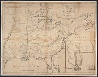
- Description:
- Reproduction of London, J. Bew, 1781, map issued by Colonial Williamsburg.
- Publisher:
- s.n.,
- Subject (Geographic):
- Chesapeake Bay (Md. and Va.)--Maps--Early works to 1800
- Found in:
- Beinecke Rare Book and Manuscript Library > A Map and Chart of these parts of the Bay of Chesapeak. York and James Rivers wich are at present the seat of war.
- Published / Created:
- 1774
- Call Number:
- 62 1774
- Container / Volume:
- BRBL_00333
- Image Count:
- 1
- Resource Type:
- Maps, Atlases & Globes
- Publisher:
- Printed for Robt. Sayer,
- Subject (Geographic):
- Ethiopia--Maps--Early works to 1800
- Found in:
- Beinecke Rare Book and Manuscript Library > A Map of Abyssinia and Nubia, By Samuel Dunn.
- Published / Created:
- [1833?]
- Call Number:
- 764 AM47 1833
- Container / Volume:
- BRBL_00453
- Image Count:
- 1
- Resource Type:
- Maps, Atlases & Globes
- Publisher:
- Pendleton Lith.,
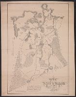
- Found in:
- Beinecke Rare Book and Manuscript Library > A Map of Amherst with a view of the College ... by Alonzo Gray & Charles B. Adams ... 1833.
- Published / Created:
- 1722]
- Call Number:
- 755 1722A
- Container / Volume:
- BRBL_00425
- Image Count:
- 1
- Resource Type:
- Maps, Atlases & Globes
- Publisher:
- s. n.,
- Subject (Geographic):
- East (U.S.)--Maps--Early works to 1800
- Found in:
- Beinecke Rare Book and Manuscript Library > A Map of Carolana and the river of Meschacebe.
- Published / Created:
- 1757
- Call Number:
- 304 1757
- Container / Volume:
- BRBL_00033
- Image Count:
- 1
- Resource Type:
- Maps, Atlases & Globes
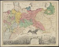
- Description:
- Preliminary record.
- Subject (Geographic):
- Europe, Central--Maps--Early works to 1800
- Found in:
- Beinecke Rare Book and Manuscript Library > A Map of Central Europe.
- Published / Created:
- 1801
- Call Number:
- 3191 1801
- Container / Volume:
- BRBL_00041
- Image Count:
- 1
- Resource Type:
- Maps, Atlases & Globes
- Description:
- Preliminary record.
- Publisher:
- Jones & Smith Se.,
- Subject (Geographic):
- Great Britain--Maps
- Found in:
- Beinecke Rare Book and Manuscript Library > A Map of England, Wales, & Scotland ... by W. Faden ...
- Published / Created:
- [1830?]
- Call Number:
- 764 H59 1830
- Container / Volume:
- BRBL_00457
- Image Count:
- 1
- Resource Type:
- Maps, Atlases & Globes
- Publisher:
- Pendleton's Lithog.,
- Subject (Geographic):
- Hingham (Mass.)--Maps
- Found in:
- Beinecke Rare Book and Manuscript Library > A Map of Hingham surveyed by Jedediah Lincon and Reuben hersey Jr. in 1830.
- Published / Created:
- [1795?]
- Call Number:
- 327 1795A
- Container / Volume:
- BRBL_00072
- Image Count:
- 1
- Resource Type:
- Maps, Atlases & Globes
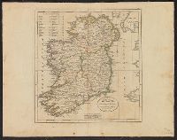
- Subject (Geographic):
- Ireland--Maps--Early works to 1800
- Found in:
- Beinecke Rare Book and Manuscript Library > A Map of Ireland ...
- Published / Created:
- 1795
- Call Number:
- 327 1795B
- Container / Volume:
- BRBL_00072
- Image Count:
- 1
- Resource Type:
- Maps, Atlases & Globes
- Description:
- From Carey's American Edition of Guthrie's Geography Improved.
- Publisher:
- Mathew Carey,
- Subject (Geographic):
- Ireland--Maps--Early works to 1800
- Found in:
- Beinecke Rare Book and Manuscript Library > A Map of Ireland according to the best authorities.