
You Searched For
1 - 7 of 7
Search Results
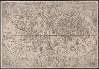
2.
- Creator:
- Plancius, Petrus, 1552-1622
- Published / Created:
- [1594]
- Call Number:
- 11 1594
- Container / Volume:
- BRBL_00002
- Image Count:
- 1
- Resource Type:
- Maps, Atlases & Globes
- Alternative Title:
- Orbis terrarvm typvs de integro multis in locis emendatus
- Description:
- Copy 2: Imperfect: chipped along folds, with some loss of text. Backed with paper.
- Publisher:
- [Petrus Plancius],
- Subject (Name):
- Doetecam, Jan van, engraver
- Subject (Topic):
- World maps--Early works to 1800
- Found in:
- Beinecke Rare Book and Manuscript Library > Orbis terrarum typus de integro multis in locis emendatus [cartographic material] / auctore Petro Plancio, 1594 ; Ioannes à Duetecum iunior fecit.
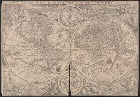
3.
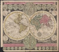
- Creator:
- Zuerner, Adam Friedrich, 1680-1742
- Published / Created:
- [1709?]
- Call Number:
- 11 1709
- Container / Volume:
- BRBL_00680
- Image Count:
- 1
- Resource Type:
- Maps, Atlases & Globes
- Alternative Title:
- Vlakke aard-kloot met het beide hemelsch half-rond, of de onder scheidene verbeelding van de land-water-waereld
- Description:
- "De Warmoes Straat sub signo R. Visschers Athlas".
- Publisher:
- Ex officina Petri Schenkii ...,
- Subject (Geographic):
- Australia--Maps--Early works to 1800
- Subject (Name):
- Schenk, Peter, 1660-1718 or 1719. Atlas contractus
- Subject (Topic):
- World maps--Early works to 1800
- Found in:
- Beinecke Rare Book and Manuscript Library > Planisphaerium terrestre cum utroque coelesti hemisphaerio, sive diversa orbis terraquei = Vlakke aard-kloot met het beide hemelsch half-rond, of de onder scheidene verbeelding van de land-water-waereld / opera et studio A.F. Zürneri.
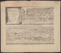
4.

- Published / Created:
- 1652?]
- Call Number:
- 11 1652
- Container / Volume:
- BRBL_00732
- Image Count:
- 4
- Resource Type:
- Maps, Atlases & Globes
- Alternative Title:
- Peutinger table. and Tabula itineraria ex illustri Peutingerorum
- Description:
- Tabvlae Pevtingerianae segmentvm primvm, ab ostiis Rheni bonnam vsque -- Segmentvm secvndvm à bonna vsque ad Marcomannos -- Tabvlae Pevtingerianae segmentvm III a Marcomannis ad Sarmatas vsque -- Segmentvm IV a Sarmatis vsque ad Hamaxobios -- Tabvlae...
- Publisher:
- prostant apud Joannem Janssonium,
- Subject (Name):
- Horn, Georg, 1620-1670, Jansson, Jan, 1588-1664. Accuratissima Orbis antiqui delineatio... [1652?], Jansson, Jan, 1588-1664. Novus atlas, Peutinger, Konrad, 1465-1546 or 7, and Welser, Marcus, 1558-1614
- Subject (Topic):
- Roads, Roman--Maps--Early works to 1800 and World maps--Early works to 1800
- Found in:
- Beinecke Rare Book and Manuscript Library > Tabvla itineraria ex illustri Peutingerorum, bibliotheca quae Augustae Vindelicorum / beneficio Marci Velseri, septem-viri Augustani in lucem edita.
5.
- Creator:
- Horn, Georg, 1620-1670
Jansson, Jan, 1588-1664. Accuratissima Orbis antiqui delineatio... [1652?]
Jansson, Jan, 1588-1664. Novus Atlas
Peutinger, Konrad, 1465-1546 or 7
Welser, Marcus, 1558-1614 - Published / Created:
- 1652?]
- Call Number:
- 314 1654
- Container / Volume:
- BRBL_00038
- Image Count:
- 4
- Resource Type:
- Maps, Atlases & Globes
- Alternative Title:
- Peutinger table. and Tabula itineraria ex illustri Peutingerorum
- Description:
- From: Accuratissima Orbis antiqui delineatio...by J. Jansson [1652?]
- Publisher:
- prostant apud Joannem Janssonium,
- Subject (Geographic):
- Roman Empire Maps--Early works to 1800
- Subject (Topic):
- Roads, Roman--Maps--Early works to 1800 and World maps--Early works to 1800
- Found in:
- Beinecke Rare Book and Manuscript Library > Tabvla itineraria ex illustri Peutingerorum, bibliotheca quae Augustae Vindelicorum / beneficio Marci Velseri, septem-viri Augustani in lucem edita.
6.

- Creator:
- Münster, Sebastian, 1489-1552
- Published / Created:
- [1532]
- Call Number:
- 11 1509A
- Image Count:
- 1
- Resource Type:
- Maps, Atlases & Globes
- Abstract:
- Decorated with sea monsters, mermaids, exotic animals, and cannibals, this wood cut map provides a marked contrast to the simplistic diagrams considered the earliest printed world maps. While the latter presented a world view based in Judeo-Christian ...
- Alternative Title:
- Typus cosmographicus universalis and Typvs cosmographicvs vniversalis
- Description:
- Appears in Johann Huttich's Novus orbis regionum. Basel. 1532.
- Publisher:
- [publisher not identified],
- Subject (Name):
- Holbein, Hans, 1497-1543 and Huttich, Johann, 1480?-1544. Novus orbis regionum.
- Subject (Topic):
- World maps--Early works to 1800
- Found in:
- Beinecke Rare Book and Manuscript Library > Typus cosmographicus uniuersalis.
7.

- Creator:
- Mercator, Gerhard, 1512-1594, cartographer
- Published / Created:
- [19--]
- Call Number:
- 11 1538B
- Image Count:
- 1
- Resource Type:
- Maps, Atlases & Globes
- Description:
- "Photolithographed copy of Gerard Mercator's Mapamundi of 1538 from an original engraving in the library of the American Geographical Society."
- Publisher:
- Julius Bien & Co., photo-lith,
- Subject (Geographic):
- World--Maps--Early works to 1800
- Subject (Name):
- American Geographical Society of New York and Julius Bien & Co
- Subject (Topic):
- Early maps, Early maps--Facsimiles, World maps, and World maps--Early works to 1800
- Found in:
- Beinecke Rare Book and Manuscript Library > [Mapamundi of 1538] [cartographic material].