Skip to search
Skip to main content
Skip to first result
Search
You Searched For
Extent of Digitization
Completely digitized
Genre
World maps
Search Results
Published / Created:
1652?]
Call Number:
11 1652
Container / Volume:
BRBL_00732
Image Count:
4
Resource Type:
Maps, Atlases & Globes
Alternative Title:
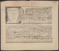
Peutinger table. and Tabula itineraria ex illustri Peutingerorum
Description:
Tabvlae Pevtingerianae segmentvm primvm, ab ostiis Rheni bonnam vsque -- Segmentvm secvndvm à bonna vsque ad Marcomannos -- Tabvlae Pevtingerianae segmentvm III a Marcomannis ad Sarmatas vsque -- Segmentvm IV a Sarmatis vsque ad Hamaxobios -- Tabvlae...
Publisher:
prostant apud Joannem Janssonium,
Subject (Name):
Horn, Georg, 1620-1670, Jansson, Jan, 1588-1664. Accuratissima Orbis antiqui delineatio... [1652?], Jansson, Jan, 1588-1664. Novus atlas, Peutinger, Konrad, 1465-1546 or 7, and Welser, Marcus, 1558-1614
Subject (Topic):
Roads, Roman--Maps--Early works to 1800 and World maps--Early works to 1800
Found in:
Beinecke Rare Book and Manuscript Library > Tabvla itineraria ex illustri Peutingerorum, bibliotheca quae Augustae Vindelicorum / beneficio Marci Velseri, septem-viri Augustani in lucem edita.
Creator:
Published / Created:
1652?]
Call Number:
314 1654
Container / Volume:
BRBL_00038
Image Count:
4
Resource Type:
Maps, Atlases & Globes
Alternative Title:
Peutinger table. and Tabula itineraria ex illustri Peutingerorum
Description:
From: Accuratissima Orbis antiqui delineatio...by J. Jansson [1652?]
Publisher:
prostant apud Joannem Janssonium,
Subject (Geographic):
Roman Empire Maps--Early works to 1800
Subject (Topic):
Roads, Roman--Maps--Early works to 1800 and World maps--Early works to 1800
Found in:
Beinecke Rare Book and Manuscript Library > Tabvla itineraria ex illustri Peutingerorum, bibliotheca quae Augustae Vindelicorum / beneficio Marci Velseri, septem-viri Augustani in lucem edita.
Creator:
Call Number:
11 1840C
Image Count:
1
Resource Type:
Maps, Atlases & Globes
Description:
Imperfect: chipped.
Subject (Name):
Copley, Charles, engraver, Karpinski, Louis Charles,--1878-1956--Ownership., Karpinski-von Wieser Map Collection., and Wieser, Franz,--Ritter von,--1848-1923--Ownership.
Subject (Topic):
World maps
Found in:
Beinecke Rare Book and Manuscript Library > The world on Mercator's projection : intermediate series / engraved by Charles Copley.
Creator:
Published / Created:
1852
Call Number:
11 1852A
Container / Volume:
BRBL_00009
Image Count:
1
Resource Type:
Maps, Atlases & Globes
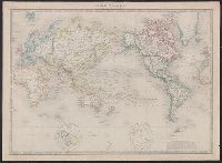
Description:
Relief shown by hachures.
Subject (Geographic):
World--maps
Subject (Topic):
World maps
Found in:
Beinecke Rare Book and Manuscript Library > The world, on Mercator's projection.
Creator:
Published / Created:
Sep., 1914 [that is, 1916]
Call Number:
BrSides Elephant Folio 2018 22
Image Count:
1
Resource Type:
Maps, Atlases & Globes
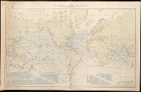
Description:
"No. 1262."
Publisher:
Published ... at the Hydrographic Office,
Subject (Topic):
Steam-navigation--Maps.
Found in:
Beinecke Rare Book and Manuscript Library > Tracks for full powered steam vessels with the shortest navigable distances in nautical miles from anchorage to anchorage, New York distances are measures to and from the Battery achorage.
Creator:
Published / Created:
Sep., 1914 [that is, 1918]
Call Number:
BrSides Elephant Folio 2018 21
Image Count:
1
Resource Type:
Maps, Atlases & Globes
Description:
"No. 1262."
Publisher:
Published ... at the Hydrographic Office,
Subject (Topic):
Steam-navigation--Maps.
Found in:
Beinecke Rare Book and Manuscript Library > Tracks for full powered steam vessels with the shortest navigable distances in nautical miles from anchorage to anchorage, New York distances are measures to and from the Battery achorage.
Creator:
Published / Created:
[1532]
Call Number:
11 1509A
Image Count:
1
Resource Type:
Maps, Atlases & Globes
Abstract:
Decorated with sea monsters, mermaids, exotic animals, and cannibals, this wood cut map provides a marked contrast to the simplistic diagrams considered the earliest printed world maps. While the latter presented a world view based in Judeo-Christian ...
Alternative Title:
Typus cosmographicus universalis and Typvs cosmographicvs vniversalis
Description:
Appears in Johann Huttich's Novus orbis regionum. Basel. 1532.
Publisher:
[publisher not identified],
Subject (Name):
Holbein, Hans, 1497-1543 and Huttich, Johann, 1480?-1544. Novus orbis regionum.
Subject (Topic):
World maps--Early works to 1800
Found in:
Beinecke Rare Book and Manuscript Library > Typus cosmographicus uniuersalis.
Creator:
Published / Created:
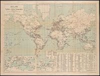
[1911?]
Call Number:
BrSides Double Folio 2018 94
Image Count:
1
Resource Type:
Maps, Atlases & Globes
Description:
Includes two inset maps: Mittelländisches Meer (1:18,000,000) and Nordsee und Kanal (1:10,800,000).
Publisher:
Gea Verlag G.m.b.H.,
Subject (Name):
Berliner Lithographisches Institut
Subject (Topic):
Cables, Submarine--Maps. and Telegraph--Maps.
Found in:
Beinecke Rare Book and Manuscript Library > Weltkarte der Funken- u. Kabel-Telegraphie.
Creator:
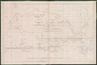
Published / Created:
1851
Call Number:
11DB 1851A-1
Container / Volume:
BRBL_00774
Image Count:
1
Resource Type:
Maps, Atlases & Globes
Alternative Title:
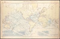
[Maury map collection ; ser. F1]
Description:
DLC
Publisher:
National Observatory,
Subject (Name):
Maury, Matthew Fontaine, 1806-1873. Wind and current charts, United States Naval Observatory, United States. Bureau of Ordnance and Hydrography, W. Endicott & Co, and Warrington, L. (Lewis), 1782-1851
Subject (Topic):
Right whales--Maps, Sperm whale--Maps, Whales--Maps, and Whaling--Maps
Found in:
Beinecke Rare Book and Manuscript Library > Whale chart [cartographic material] : preliminary sketch / by M.F. Maury, A.M. Lieut., U.S. Navy ; constructed by Lts. Leigh. Herndon & Fleming & Pd. Midn. Jackson.
Creator:
Published / Created:
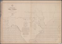
1852
Call Number:
11cfk 1850F
Container / Volume:
BRBL_00774
Image Count:
4
Resource Type:
Maps, Atlases & Globes
Alternative Title:
[Maury map collection ; Series F4], Maury's wind & current chart : whale sheet, and Whale sheet
Description:
"Series F."
Publisher:
United States Hydrographical Office,
Subject (Name):
Maury, Matthew Fontaine, 1806-1873. Wind and current charts, United States. Bureau of Ordnance and Hydrography, and United States. Hydrographic Office
Subject (Topic):
Ocean--Maps, Right whales--Maps, Sperm whale--Maps, and Whales--Maps
Found in:
Beinecke Rare Book and Manuscript Library > Whale chart of the world [cartographic material] / by M.F. Maury, L.L.D. Lieut. U.S. Navy, superin'dt. of U.S.N. Observatory ; compiled from materials in the Bureau of Ordnance and Hydrography by P.M. A.C. Jackson.
Branch:v1.68.7 ,Deployed:2025-07-09T09:08:23-04:00