Skip to search
Skip to main content
Skip to first result
Search
You Searched For
Extent of Digitization
Completely digitized
Language
Dutch; Flemish
Search Results
Creator:
Published / Created:
1700?]
Call Number:
331 1700A
Container / Volume:
BRBL_00078
Image Count:
1
Resource Type:
Maps, Atlases & Globes
Description:
"Cum privil."
Publisher:
Peter Schenk?
Subject (Geographic):
East Indies--Maps--Early works to 1800, Netherlands--Maps--Early works to 1800, and New Netherland--Maps--Early works to 1800
Found in:
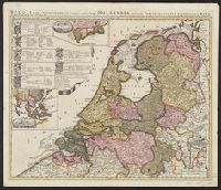
Beinecke Rare Book and Manuscript Library > Belgii pars septentrionalis communi nomine vulgo Hollandia : nuncupata continens statum potentissimae Batavorum Reipublicae seu Provincias VII. foederatas. Cum omnium provinciarum insignibus, additis omnibus nominibus urbium et pagorum edente / Petro Sche
Published / Created:
1635
Call Number:
3331 Sc28 1635
Container / Volume:
BRBL_00082
Image Count:
1
Resource Type:
Maps, Atlases & Globes
Description:
Preliminary record.
Subject (Geographic):
North Holland (Netherlands)--Maps--Early works to 1800
Found in:
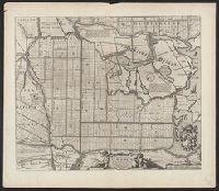
Beinecke Rare Book and Manuscript Library > Caerte van de Scher-meer...1635...
Creator:
Published / Created:
1687
Call Number:
7855 1687
Container / Volume:
BRBL_00691
Image Count:
1
Resource Type:
Maps, Atlases & Globes
Description:
Below title in cartouche: "Met privilegio voor 15 iaaren ao 1687."
Publisher:
s.n.],
Subject (Geographic):
Atlantic Coast (South Atlantic States)--Nautical charts--Early works to 1800 and South Carolina--Nautical charts--Early works to 1800
Subject (Topic):
Nautical charts--Atlantic Coast (South Atlantic States)--Early works to 1800 and Nautical charts--South Carolina--Early works to 1800
Found in:
Beinecke Rare Book and Manuscript Library > Caerte vande cust Carolina : tusschen B. de S Matheo en C. Henry / op niew verbeetert door Iacobus Robyn.
Published / Created:
1640
Call Number:
3333 Sc26 1640
Container / Volume:
BRBL_00084
Image Count:
1
Resource Type:
Maps, Atlases & Globes
Description:
Preliminary record.
Subject (Geographic):
Scheldt River--Maps--Early works to 1800 and Zeeland (Netherlands : Province)--Maps--Early works to 1800
Found in:
Beinecke Rare Book and Manuscript Library > Caerte vant Scheldt ende Santvliet ... / door Claes Ianβ Visscher.
Creator:
Published / Created:
1743
Call Number:
1975 Folio 31
Collection Title:
[Atlas factice of 42 maps, produced by the Homann Erben firm]
Image Count:
1
Alternative Title:
Staat von der Republic Genova, nach seiner Eintheilung in die ost- u. west-Revier
Publisher:
Homann Erben
Subject (Geographic):
Genoa (Italy) --Maps --Early works to 1800
Subject (Topic):
Atlases, German --Early works to 1800
Collection Created:
[Nuremberg,
Found in:
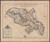
Beinecke Rare Book and Manuscript Library > Carta Geographica, la quale rappresenta lo Stato della Republica di Genova partita nella Riviera di Levante et di Ponente / [cartographic material] / data in publico per gli Heredi d'Homann ; con privil. imp le 1743 = Staat von der Republic Genova, nach s
Creator:
Published / Created:
[1742]
Call Number:
865 1732A
Container / Volume:
BRBL_00696
Image Count:
1
Resource Type:
Maps, Atlases & Globes
Description:
Bar scales given in "Lieues Marines et d'Espagne de 17 1/2 au Degré" and "Lieues Com. de France dont 25 font un Degré."
Publisher:
Chez Jean Covens et Corneille Mortier, geographes,
Subject (Geographic):
Martinique--Maps--Early works to 1800
Subject (Name):
Buache, Philippe, 1700-1773, Cóvens et Mortier, printer, and L'Isle, Guillaume de, 1675-1726. Atlas nouveau
Found in:
Beinecke Rare Book and Manuscript Library > Carte de l'Isle de la Martinique : colonie françoise de l'une des Isles Antilles de l'Amérique / dressée sur des plans manuscrits entr'autres sur celui de Mr. Houel, Ingenieur du Roy, assujetis à des observations astonomiques et concilies avec des mem
Creator:
Published / Created:
1755
Call Number:
755 1755D
Container / Volume:
BRBL_00427
Image Count:
1
Resource Type:
Maps, Atlases & Globes
Alternative Title:
Kaart van de Engelsche en Fransche bezittingen in het vaste land van Noord America. and Possessions angloises & françoises du continet de l'Amérique septentrionale.
Description:
Based on Jean Palairet's Carte des possessions angloises françoises du continent de l'Amérique septentrionale, 1755.
Publisher:
Chez R. et J. Ottens, geográphes,
Subject (Geographic):
North America--Maps--Early works to 1800
Subject (Name):
Ottens, J. (Josua), 1704-1765 and Palairet, Jean, 1697-1774. Carte des possessions angloises françoises du continent de l'Amérique septentrionale
Found in:
Beinecke Rare Book and Manuscript Library > Carte des possessions angloises & françoises du continent de l'Amérique septentrionale. Kaart van de Engelsche en Fransche bezittingen in het vaste land van Noord America.
Creator:
Published / Created:
[172-?]
Call Number:
651 172X
Container / Volume:
BRBL_00342
Image Count:
1
Resource Type:
Maps, Atlases & Globes
Description:
"Avec prívílege de nos seigneurs les etats de Holl[ande] et de Westfrise."
Publisher:
Chez Pierre Mortier libraire sur le Vygen-dam,
Subject (Geographic):
Angola--Maps--Early works to 1800
Subject (Name):
Mortier, Pierre
Subject (Topic):
Coasts--Angola--Maps--Early works to 1800
Found in:
Beinecke Rare Book and Manuscript Library > Carte particuliere des costes de l'Afrique, qui comprend une partie de Congo / is nu te bekoomen bÿ Gerard van Keulen, aan ae niewe brugh met privilegie.
Creator:
Call Number:
56 1636
Container / Volume:
BRBL_00294
Image Count:
2
Resource Type:
Maps, Atlases & Globes
Description:
From Jan Jansson's Atlas novus (Amsterdam, 1638).
Subject (Geographic):
China--Maps--Early works to 1800, Japan--Maps--Early works to 1800, and Korea--Maps--Early works to 1800
Subject (Name):
Jansson, Jan, 1588-1664. Atlas novus
Found in:
Beinecke Rare Book and Manuscript Library > China veteribus Sinarum Regio nunc incolis Tame dicta.
Creator:
Published / Created:
ca. 1680
Call Number:
Folio 469
Collection Title:
[Atlas factice of 13 maps by Nicolaes Visscher I, Nicolaes Visscher II, Guillaume Sanson, and
Image Count:
1
Publisher:
Justus Danckerts
Subject (Geographic):
Europe --Maps --Early works to 1800 and Netherlands --Maps --Early works to 1800
Subject (Topic):
Atlases, Dutch --Early works to 1800
Collection Created:
1677-1692
Found in:
Beinecke Rare Book and Manuscript Library > Comitatus Hollandiae tabula / [cartographic material] / pluribus locis recens emendata a Iusto Danckerts
Branch:v1.68.7 ,Deployed:2025-07-09T09:08:07-04:00