Skip to search
Skip to main content
Skip to first result
Search
You Searched For
Extent of Digitization
Completely digitized
Language
Portuguese
Search Results
Creator:
Published / Created:
1914
Call Number:
636 1914
Container / Volume:
BRBL_00337
Image Count:
4
Resource Type:
Maps, Atlases & Globes
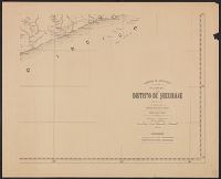
Alternative Title:
Distrito de Quelimane
Description:
Relief shown by hachures.
Publisher:
Comissão das Cartografia,
Subject (Geographic):
Zambézia Province (Mozambique)--Maps
Subject (Name):
Portugal. Comissão de Cartografia das Colónias
Found in:
Beinecke Rare Book and Manuscript Library > Carta do distrito de Quelimane (esboço) / elaborado pelo governador do distrito, Filipe Carlos Dias de Carvalho.
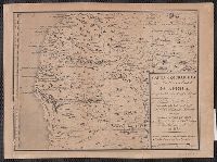
Creator:
Published / Created:
[1929-1932]
Call Number:
651 1932
Container / Volume:
BRBL_00342
Image Count:
2
Resource Type:
Maps, Atlases & Globes
Description:
Each sheet includes notes on sources., Imperfect: 3 sheets wanting., Mossamedes-sá da Bandeira -- Pereira de Eça -- Vila Serpa Pinto -- Dirico -- Cuando., and Relief shown by contours and spot heights.
Publisher:
Ministério das Colónias, Comissão de Cartografia,
Subject (Geographic):
Angola--Maps
Found in:
Beinecke Rare Book and Manuscript Library > Carta do sul de Angola, compreendendo a região situada ao sul do paralelo 14°.
Creator:
Published / Created:
[1887?]
Call Number:
651 1887
Container / Volume:
BRBL_00342
Image Count:
1
Resource Type:
Maps, Atlases & Globes
Description:
Coordinates not present on map and are approximated. and Relief shown pictorially.
Publisher:
[Sociedade de Geografia de Lisboa],
Subject (Geographic):
Angola--Maps
Found in:
Beinecke Rare Book and Manuscript Library > Carta geographica da Costa occidental da Africa : comprehendida entre 5° e 19° de Lat. śul, mostrande parte de Congo e os Reinos de Angola, Benguella etc. / desenhada pelo Tene. Coronel Engo. L.C.C. Pinheiro Furtado em 1790 ; gravada em Pariz por ordem d
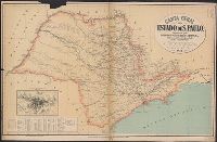
Creator:
Published / Created:
1912
Call Number:
91139 1912
Container / Volume:
BRBL_00670
Image Count:
1
Resource Type:
Maps, Atlases & Globes
Description:
Includes distance chart and inset "Planta da cidade de São Paulo" scale 1:100,000.
Publisher:
Wieszflog Irmãos,
Subject (Geographic):
São Paulo (Brazil : State)--Maps
Found in:
Beinecke Rare Book and Manuscript Library > Carta geral do Estado de S. Paulo / organisada pela Commissão Geográphico e Geológico.
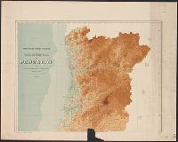
Creator:
Published / Created:
[1906]
Call Number:
397cbf 1906
Container / Volume:
BRBL_00195
Image Count:
2
Resource Type:
Maps, Atlases & Globes
Description:
Frayed with loss of text. and Relief shown by gradient tints and spot heights. Depths shown by gradient tints and soundings.
Publisher:
Commissão do Serviço Geológico,
Subject (Geographic):
Portugal--Maps
Found in:
Beinecke Rare Book and Manuscript Library > Carta hypsometrica de Portugal [cartographic material] : 1906.
Creator:
Call Number:
Manuscript 911cea 1789
Image Count:
2
Resource Type:
Maps, Atlases & Globes
Description:
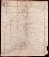
Color: red and black ink, longitude and latitude grid colored yellow., Coordinates not present on map and are approximated., and Includes information on seasonal currents.
Subject (Geographic):
Brazil--Maps--Early works to 1800.
Subject (Topic):
Coasts--Brazil--Maps--Early works to 1800.
Found in:
Beinecke Rare Book and Manuscript Library > Carta reduzida de hua parte de costa do Brasil : desde o Morro de S. Paulo athê Santos / por José Fernandes, Portugal na Bahia de Todos os Santos no Anno de 1789.
Creator:
Published / Created:
anno de 1786.
Call Number:
Art Storage 1006
Container / Volume:
BRBL_00700
Image Count:
1
Resource Type:
Maps, Atlases & Globes
Description:
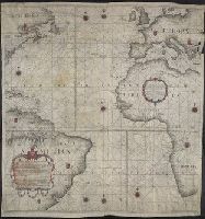
Below lower left margin: A.I.M. Faria. esc. 2., Contains nine compass roses., Copy printed on 4 sheets of vellum, joined together to form 1 sheet. Imperfect: top right edge mutilated. Hand-colored., Covers also continent of Europe as far east as Greece, Africa entire continent from north to south as far east as Libya, North America as far south west as Virginia, part of Cuba, Jamaica, West Indies, and South America as far south as far south as Buenos Aires., Dedication: "Offerecida ao Illustrissimo e Excellentisimo Senhor Luis de Vasconcellos e Souza, do Conselho de Sua Magestade Fidelissima, Vice Reij e Capitaõ General de Mar, e Terra do Estado do Brazil.", Each country and its imperial provinces demarcated with coat-of-arms., Historiated title cartouche., Includes foliated cartouche with: Declaracao Preliminar., No relief shown., Prime meridians: London, Paris, and Ferro; coordinates converted by cataloger to express longitude based on Greenwich prime meridian., and Shows continents, names of countries, coastal towns, cities, and islands.
Publisher:
[Simão Antônio da Rosa Pinheiro],
Subject (Geographic):
Atlantic Ocean--Maps, Manuscript--Early works to 1800
Subject (Name):
Faria, A. I. M.
Subject (Topic):
Nautical charts--Atlantic Ocean--Early works to 1800.
Found in:
Beinecke Rare Book and Manuscript Library > Carta reduzida, e em muijte parte reformada, pelas observacoens mais justificadas dos melhores authores, astronomos modernos, [que] pareceraõ mais coherentes, pelas exaetissimas averiguacoens de pilotos eruditos, e do roterro portugues : em que se compre
Creator:
Published / Created:
[172-?]
Call Number:
651 172X
Container / Volume:
BRBL_00342
Image Count:
1
Resource Type:
Maps, Atlases & Globes
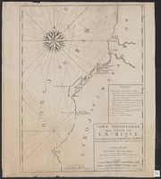
Description:
"Avec prívílege de nos seigneurs les etats de Holl[ande] et de Westfrise.", French and Dutch, with Portuguese place names., and Indexed.
Publisher:
Chez Pierre Mortier libraire sur le Vygen-dam,
Subject (Geographic):
Angola--Maps--Early works to 1800
Subject (Name):
Mortier, Pierre
Subject (Topic):
Coasts--Angola--Maps--Early works to 1800
Found in:
Beinecke Rare Book and Manuscript Library > Carte particuliere des costes de l'Afrique, qui comprend une partie de Congo / is nu te bekoomen bÿ Gerard van Keulen, aan ae niewe brugh met privilegie.
Creator:
From the Collection: Schletter, Annie, 1858-1944
Published / Created:
1907 Mar 28
Call Number:
GEN MSS 547
Container / Volume:
Box 1, folder 5
Image Count:
5
Found in:
Beinecke Rare Book and Manuscript Library > Annie Schletter papers (GEN MSS 547) > Series I: Correspondence > Annie Schletter Correspondence > Castle, Agnes Egerton
Creator:
From the Collection: Schletter, Annie, 1858-1944
Published / Created:
n.d.
Call Number:
GEN MSS 547
Container / Volume:
Box 1, folder 38
Image Count:
33
Description:
7 letters
Found in:
Beinecke Rare Book and Manuscript Library > Annie Schletter papers (GEN MSS 547) > Series I: Correspondence > Third Party Correspondence > Clark, Claude, to Pauline [Schletter]
Branch:v1.68.2 ,Deployed:2025-06-12T06:59:33-04:00