Search
You Searched For
Search Results
- Creator:
- Ringgold, Cadwalader, 1802-1867
- Published / Created:
- [1851?]
- Call Number:
- 844cea Sa52 1850A
- Container / Volume:
- BRBL_00614
- Image Count:
- 1
- Resource Type:
- Maps, Atlases & Globes
- Alternative Title:
- Entrance to San Francisco.
- Description:
- "Constructed, projected and drawn by Fred D. Stuart, hydrographer, late of the U.S. Ex. Ex."
- Publisher:
- C.B. Graham, Lithr.,
- Subject (Geographic):
- San Francisco Bay (Calif.)--Maps and San Francisco Bay Area (Calif.)--Maps
- Subject (Name):
- Blunt, Simon Fraser, d. 1854, Graham, C. B. (Curtis B.), and Stuart, Fred D
- Subject (Topic):
- Nautical charts--California--San Francisco Bay
- Found in:
- Beinecke Rare Book and Manuscript Library > Chart of the Farallones and entrance to the bay of San Francisco : California / by Cadwalader Ringgold, Commander, U.S. Navy ; assisted by Simon F. Blunt, Lieut., U.S. Navy, 1850.
- Creator:
- Ringgold, Cadwalader, 1802-1867
- Published / Created:
- [1851?]
- Call Number:
- 844cea Sa52 1850B
- Container / Volume:
- BRBL_00614
- Image Count:
- 1
- Resource Type:
- Maps, Atlases & Globes
- Description:
- "Entered according to act of Congress in the year 1851 by Cadwalader Ringgold ...."
- Publisher:
- C.B. Graham, Lithr.,
- Subject (Geographic):
- San Francisco Bay (Calif.)--Maps, San Francisco Bay Area (Calif.)--Maps, and San Pablo Bay (Calif.)--Maps
- Subject (Name):
- Blunt, Simon F, Campbell, Albert H. (Albert Henry), 1826-1899, Graham, C. B. (Curtis B.), and Stuart, Fred D
- Subject (Topic):
- Nautical charts--California--San Francisco Bay and Nautical charts--California--San Pablo Bay
- Found in:
- Beinecke Rare Book and Manuscript Library > Chart of the bay of San Pablo, Straits of Carquines, and part of the bay of San Francisco : California / by Cadwalader Ringgold, Commander, U.S. Navy ; assisted by Simon F. Blunt, Lieut., U.S.N., 1850.
- Creator:
- Mexico. Dirección de Estudios Geográficos y Climatológicos
- Published / Created:
- [1922]
- Call Number:
- 8891 1922
- Container / Volume:
- BRBL_00656
- Image Count:
- 2
- Resource Type:
- Maps, Atlases & Globes
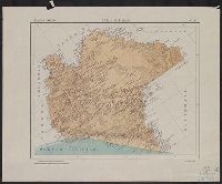
- Description:
- "No. 5."
- Publisher:
- La Dirección,
- Subject (Geographic):
- Chiapas (Mexico)--Maps
- Subject (Name):
- Mexico. Dirección de Estudios Geográficos y Climatológicos. Atlas geográfico de la República Mexicana
- Found in:
- Beinecke Rare Book and Manuscript Library > Chiapas / Secretaria de Agicultura y Fomento, Dirección de Estudios Geográficos y Climatológicos.
- Creator:
- Mexico. Dirección de Estudios Geográficos y Climatológicos
- Published / Created:
- [1922]
- Call Number:
- 8819 1922
- Container / Volume:
- BRBL_00652
- Image Count:
- 2
- Resource Type:
- Maps, Atlases & Globes
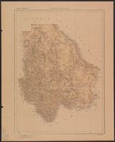
- Description:
- Accompanied by physiographic plate, showing relief and drainage only (1 sheet : col. ; 70 cm.).
- Publisher:
- La Dirección,
- Subject (Geographic):
- Chihuahua (Mexico : State)--Maps
- Found in:
- Beinecke Rare Book and Manuscript Library > Chihuahua.
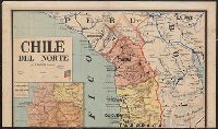
- Creator:
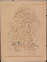
- Robelin, L
- Published / Created:
- 1891?]
- Call Number:
- 96 1891
- Container / Volume:
- BRBL_00676
- Image Count:
- 2
- Resource Type:
- Maps, Atlases & Globes
- Description:
- 3 insets.
- Publisher:
- s.n.,
- Subject (Geographic):
- Chile--Maps
- Found in:
- Beinecke Rare Book and Manuscript Library > Chile del Norte / por L. Robelin.
- Creator:
- Mexico. Secretaría de Estado y del Despacho de Relaciones Interiores y Exteriores
- Published / Created:
- 1822
- Call Number:
- 1991 +S5 1822 10/14 1
- Image Count:
- 3
- Resource Type:
- Books, Journals & Pamphlets
- Description:
- Circular justifying the government's actions in supressing an alleged Republican conspiracy in August 1822.
- Subject (Geographic):
- Mexico--Politics and government--1821-1861
- Subject (Name):
- Herrera, José Manuel de, 1776?-1831 and Wagner, Henry Raup, 1862-1957--Collection
- Subject (Topic):
- Conspiracies--Mexico, Lat Amer Tracts--1822, and Republicanism--Mexico
- Found in:
- Beinecke Rare Book and Manuscript Library > Circular de la primera Secretaria de Estado y Relaciones.
- Creator:
- Mexico. Dirección de Estudios Geográficos y Climatológicos
- Published / Created:
- [1929]
- Call Number:
- 8818 1929
- Container / Volume:
- BRBL_00651
- Image Count:
- 2
- Resource Type:
- Maps, Atlases & Globes
- Description:
- "No. 7."
- Publisher:
- La Dirección,
- Subject (Geographic):
- Coahuila (Mexico : State)--Maps
- Subject (Name):
- Mexico. Dirección de Estudios Geográficos y Climatológicos. Atlas geográfico de la República Mexicana
- Found in:
- Beinecke Rare Book and Manuscript Library > Coahuila / Secretaría de Agricultura y Fomento, Dirección de Estudios Geográficos y Climatológicos.
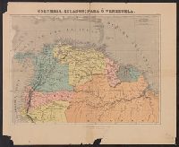
- Published / Created:
- 1920
- Call Number:
- 902 1920B
- Container / Volume:
- BRBL_00665
- Image Count:
- 1
- Resource Type:
- Maps, Atlases & Globes
- Publisher:
- L. Turgis et Fils,
- Subject (Geographic):
- Colombia--Maps, Ecuador--Maps, and Venezuela--Maps
- Found in:
- Beinecke Rare Book and Manuscript Library > Colombia, Ecuador; Para ò Venezuela.