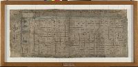
Nahuatl map on maguey paper documenting agricultural holdings in the Valley of Mexico, probably fields of bulrush or maize under the colonial jurisdiction of Tenochtitlan-Mexico City, ca. 1565
Description:
Available on x-ray film
Subject (Geographic):
Mexico, Mexico., Mexico City (Mexico), and Mexico, Valley of (Mexico)
Subject (Name):
Alvarado Huanitzin, Don Diego de., Cecepátic, Don Cristóbal de., Guzmán, Don Esteban de., San Francisco Tehuetzquititzin, Don Diego de., Santa María Cipac, Don Luis de., and Velasco, Luis de, 1500?-1564.
Subject (Topic):
Agriculture, Corn, Indian cartography, Indians of Mexico, Discovery and exploration, History, Maps, and Early works to 1800