Skip to search
Skip to main content
Skip to first result
Search
You Searched For
Extent of Digitization
Completely digitized
Subject (Topic)
World maps--Early works to 1800
Search Results
Creator:
Published / Created:
[1594]
Call Number:
11 1594
Container / Volume:
BRBL_00002
Image Count:
1
Resource Type:
Maps, Atlases & Globes
Alternative Title:
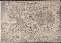
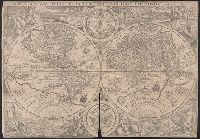
Orbis terrarvm typvs de integro multis in locis emendatus
Description:
Copy 1: Imperfect: chipped along folds, with some loss of text. Backed with linen.
Publisher:
[Petrus Plancius],
Subject (Name):
Doetecam, Jan van, engraver
Subject (Topic):
World maps--Early works to 1800
Found in:
Beinecke Rare Book and Manuscript Library > Orbis terrarum typus de integro multis in locis emendatus [cartographic material] / auctore Petro Plancio, 1594 ; Ioannes à Duetecum iunior fecit.
Creator:
Published / Created:
[1594]
Call Number:
11 1594
Container / Volume:
BRBL_00002
Image Count:
1
Resource Type:
Maps, Atlases & Globes
Alternative Title:
Orbis terrarvm typvs de integro multis in locis emendatus
Description:
Copy 2: Imperfect: chipped along folds, with some loss of text. Backed with paper.
Publisher:
[Petrus Plancius],
Subject (Name):
Doetecam, Jan van, engraver
Subject (Topic):
World maps--Early works to 1800
Found in:
Beinecke Rare Book and Manuscript Library > Orbis terrarum typus de integro multis in locis emendatus [cartographic material] / auctore Petro Plancio, 1594 ; Ioannes à Duetecum iunior fecit.
Creator:
Published / Created:
[1653]
Call Number:
13 1653
Container / Volume:
BRBL_00011
Image Count:
1
Resource Type:
Maps, Atlases & Globes
Alternative Title:
Orbis terrarvm veteribvs cogniti typvs geographicvs
Description:
Appears in Jansson's Accuratissima orbis antiqui delineatio, 1653.
Publisher:
Iohan Ianssonius,
Subject (Geographic):
Eastern Hemisphere--Maps--Early works to 1800
Subject (Topic):
World maps--Early works to 1800
Found in:
Beinecke Rare Book and Manuscript Library > Orbis terrarum veteribus cogniti typus geographicus.
Creator:
Published / Created:
1750?]
Call Number:
11 1750
Image Count:
1
Resource Type:
Maps, Atlases & Globes
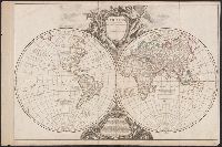
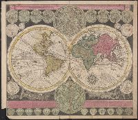
Description:
Double-hemispherical world map.
Publisher:
Chez Delamarche,
Subject (Geographic):
World--Maps--Early works to 1800
Subject (Topic):
World maps--Early works to 1800
Found in:
Beinecke Rare Book and Manuscript Library > Orbis vetus in utrâque continente ... / accurante Robert de Vaugondy.
Creator:
Published / Created:
1716?]
Call Number:
11 1716
Container / Volume:
BRBL_00680
Image Count:
1
Resource Type:
Maps, Atlases & Globes
Description:
Cross collection no. 28.
Publisher:
s.n.,
Subject (Topic):
World maps--Early works to 1800
Found in:
Beinecke Rare Book and Manuscript Library > Planiglobii terrestris cum utroq hemisphaerio caelesti generalis repraesentatio [cartographic material] : quam ex novissimis probatissimisque recentium geographorum scriptis concinnatam, multisq[ue] phaenomenis illustratam / publice proponit Io. Bapt. Hom
Creator:
Published / Created:
1746
Call Number:
11 1746A
Container / Volume:
BRBL_00681
Image Count:
1
Resource Type:
Maps, Atlases & Globes
Alternative Title:
Mappe-monde qui représente les deux hemisphères savoir celui de l'orient et celui de l'occident, tirée des quatre cartes générales de feu M. le profess. Hasius, Planiglobii terrestris mappa vniversalis, and Schul-Atlas von zwantzig General- und Special-Lan
Description:
Appears in Homann heirs' Schul-atlas von zwantzig general-und special-land karten ... Cf. Phillips, no. 293.
Publisher:
Homann Erben],
Subject (Name):
Hase, Johann Matthias, 1684-1742 and Homann Erben (Firm)
Subject (Topic):
Religion--Maps--Early works to 1800 and World maps--Early works to 1800
Found in:
Beinecke Rare Book and Manuscript Library > Planiglobii terrestris mappa universalis utrumq[ue] hemisphaerium orient. et occidentale repraesentans, ex IV. mappis generalibus, Hasianis composita et adjectis ceteris hemisphaeriis / designata a G.M. Lowizio ; excudentibus Homann. Heredibus = Mappe-mon
Creator:
Published / Created:
[1709?]
Call Number:
11 1709
Container / Volume:
BRBL_00680
Image Count:
1
Resource Type:
Maps, Atlases & Globes
Alternative Title:
Vlakke aard-kloot met het beide hemelsch half-rond, of de onder scheidene verbeelding van de land-water-waereld
Description:
"De Warmoes Straat sub signo R. Visschers Athlas".
Publisher:
Ex officina Petri Schenkii ...,
Subject (Geographic):
Australia--Maps--Early works to 1800
Subject (Name):
Schenk, Peter, 1660-1718 or 1719. Atlas contractus
Subject (Topic):
World maps--Early works to 1800
Found in:
Beinecke Rare Book and Manuscript Library > Planisphaerium terrestre cum utroque coelesti hemisphaerio, sive diversa orbis terraquei = Vlakke aard-kloot met het beide hemelsch half-rond, of de onder scheidene verbeelding van de land-water-waereld / opera et studio A.F. Zürneri.
Creator:
Published / Created:
1780?]
Call Number:
11 1780
Container / Volume:
BRBL_00722
Image Count:
1
Resource Type:
Maps, Atlases & Globes
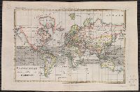
Description:
From Bonne's Atlas de toutes les parties connues du globe terrestre ... [Paris : J.L. Pellet, 1780?].
Publisher:
J.L. Pellet,
Subject (Name):
Bonne, Rigobert, 1727-1794. Atlas de toutes les parties connues du globe terrestre .. and Pellet, J.-L. (Jean-Léonard), publisher
Subject (Topic):
Cartographers--France--18th century and World maps--Early works to 1800
Found in:
Beinecke Rare Book and Manuscript Library > Planisphere suivant la projection de Mercator.
Published / Created:
1652?]
Call Number:
11 1652
Container / Volume:
BRBL_00732
Image Count:
4
Resource Type:
Maps, Atlases & Globes
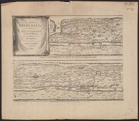
Alternative Title:
Peutinger table. and Tabula itineraria ex illustri Peutingerorum
Description:
Tabvlae Pevtingerianae segmentvm primvm, ab ostiis Rheni bonnam vsque -- Segmentvm secvndvm à bonna vsque ad Marcomannos -- Tabvlae Pevtingerianae segmentvm III a Marcomannis ad Sarmatas vsque -- Segmentvm IV a Sarmatis vsque ad Hamaxobios -- Tabvlae...
Publisher:
prostant apud Joannem Janssonium,
Subject (Name):
Horn, Georg, 1620-1670, Jansson, Jan, 1588-1664. Accuratissima Orbis antiqui delineatio... [1652?], Jansson, Jan, 1588-1664. Novus atlas, Peutinger, Konrad, 1465-1546 or 7, and Welser, Marcus, 1558-1614
Subject (Topic):
Roads, Roman--Maps--Early works to 1800 and World maps--Early works to 1800
Found in:
Beinecke Rare Book and Manuscript Library > Tabvla itineraria ex illustri Peutingerorum, bibliotheca quae Augustae Vindelicorum / beneficio Marci Velseri, septem-viri Augustani in lucem edita.
Creator:
Published / Created:
1652?]
Call Number:
314 1654
Container / Volume:
BRBL_00038
Image Count:
4
Resource Type:
Maps, Atlases & Globes
Alternative Title:
Peutinger table. and Tabula itineraria ex illustri Peutingerorum
Description:
From: Accuratissima Orbis antiqui delineatio...by J. Jansson [1652?]
Publisher:
prostant apud Joannem Janssonium,
Subject (Geographic):
Roman Empire Maps--Early works to 1800
Subject (Topic):
Roads, Roman--Maps--Early works to 1800 and World maps--Early works to 1800
Found in:
Beinecke Rare Book and Manuscript Library > Tabvla itineraria ex illustri Peutingerorum, bibliotheca quae Augustae Vindelicorum / beneficio Marci Velseri, septem-viri Augustani in lucem edita.
Branch:v1.68.6 ,Deployed:2025-07-02T08:09:31-04:00