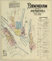
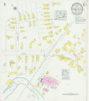
Sanborn fire insurance maps are a rich source of historic data on the urban built environment of North America during the 19th and early 20th centuries. The atlases were created for the purpose of underwriting fire insurance policies, which depended u...
Alternative Title:
June 1886, Birmingham, Conn.
Description:
"11 sheets."
Subject (Geographic):
Derby (Conn.)--Maps and Shelton (Conn.)--Maps
Subject (Name):
Library of Congress Stamp
Subject (Topic):
Fire risk assessment--Connecticut--Derby--Maps, Fire risk assessment--Connecticut--Shelton--Maps, Real property--Connecticut--Derby--Maps, and Real property--Connecticut--Shelton--Maps
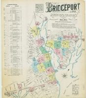
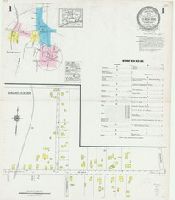
Sanborn fire insurance maps are a rich source of historic data on the urban built environment of North America during the 19th and early 20th centuries. The atlases were created for the purpose of underwriting fire insurance policies, which depended u...
Alternative Title:
March 1884, Bridgeport, Conn.
Description:
"20 sheets."
Subject (Geographic):
Bridgeport (Conn.)--Maps
Subject (Name):
Library of Congress Stamp
Subject (Topic):
Fire risk assessment--Connecticut--Bridgeport--Maps and Real property--Connecticut--Bridgeport--Maps
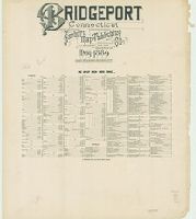
Sanborn fire insurance maps are a rich source of historic data on the urban built environment of North America during the 19th and early 20th centuries. The atlases were created for the purpose of underwriting fire insurance policies, which depended u...
Alternative Title:
Bridgeport, Conn.
Description:
Contains information on population, prevailing winds, water facilities and fire department.
Subject (Geographic):
Bridgeport (Conn.)--Maps
Subject (Name):
Library of Congress Stamp
Subject (Topic):
Fire risk assessment--Connecticut--Bridgeport--Maps and Real property--Connecticut--Bridgeport--Maps
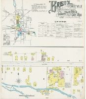
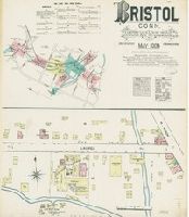
Sanborn fire insurance maps are a rich source of historic data on the urban built environment of North America during the 19th and early 20th centuries. The atlases were created for the purpose of underwriting fire insurance policies, which depended u...
Alternative Title:
May 1890, Bristol, Conn.
Description:
"(3776) 9 sheets."
Subject (Geographic):
Bristol (Conn.)--Maps
Subject (Name):
Library of Congress Stamp
Subject (Topic):
Fire risk assessment--Connecticut--Bristol--Maps and Real property--Connecticut--Bristol--Maps
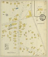
Sanborn fire insurance maps are a rich source of historic data on the urban built environment of North America during the 19th and early 20th centuries. The atlases were created for the purpose of underwriting fire insurance policies, which depended u...
Alternative Title:
May 1884, Bristol, Conn.
Description:
"5 sheets."
Subject (Geographic):
Bristol (Conn.)--Maps
Subject (Name):
Library of Congress Stamp
Subject (Topic):
Fire risk assessment--Connecticut--Bristol--Maps and Real property--Connecticut--Bristol--Maps
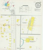
Sanborn fire insurance maps are a rich source of historic data on the urban built environment of North America during the 19th and early 20th centuries. The atlases were created for the purpose of underwriting fire insurance policies, which depended u...
Description:
"760."
Subject (Geographic):
Canaan (Conn.)--Maps
Subject (Name):
Library of Congress Stamp
Subject (Topic):
Fire risk assessment--Connecticut--Canaan--Maps and Real property--Connecticut--Canaan--Maps
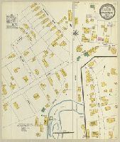
Sanborn fire insurance maps are a rich source of historic data on the urban built environment of North America during the 19th and early 20th centuries. The atlases were created for the purpose of underwriting fire insurance policies, which depended u...
Alternative Title:
May 1909, Canaan, Conn.
Description:
"1436, 3 sheets."
Subject (Geographic):
Canaan (Conn.)--Maps
Subject (Name):
Library of Congress Stamp
Subject (Topic):
Fire risk assessment--Connecticut--Canaan--Maps and Real property--Connecticut--Canaan--Maps
Sanborn fire insurance maps are a rich source of historic data on the urban built environment of North America during the 19th and early 20th centuries. The atlases were created for the purpose of underwriting fire insurance policies, which depended u...
Description:
"(6399)."
Subject (Geographic):
Plainfield (Conn.)--Maps
Subject (Name):
Library of Congress Stamp and Library of Congress. Map Division Stamp
Subject (Topic):
Fire risk assessment--Connecticut--Plainfield--Maps and Real property--Connecticut--Plainfield--Maps
Sanborn fire insurance maps are a rich source of historic data on the urban built environment of North America during the 19th and early 20th centuries. The atlases were created for the purpose of underwriting fire insurance policies, which depended u...
Alternative Title:
June 1927, Central Village, Conn.
Description:
"(3170) (2 sheets)."
Subject (Geographic):
Plainfield (Conn.)--Maps
Subject (Name):
Library of Congress Stamp
Subject (Topic):
Fire risk assessment--Connecticut--Plainfield--Maps and Real property--Connecticut--Plainfield--Maps
Sanborn fire insurance maps are a rich source of historic data on the urban built environment of North America during the 19th and early 20th centuries. The atlases were created for the purpose of underwriting fire insurance policies, which depended u...
Alternative Title:
Jan. 1925, Cheshire, Conn.
Description:
"(2002) (6 sheets)."
Subject (Geographic):
Cheshire (Conn.)--Maps
Subject (Name):
Library of Congress Stamp
Subject (Topic):
Fire risk assessment--Connecticut--Cheshire--Maps and Real property--Connecticut--Cheshire--Maps