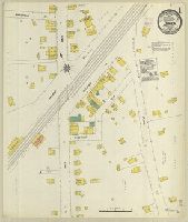
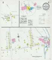
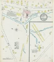
Sanborn fire insurance maps are a rich source of historic data on the urban built environment of North America during the 19th and early 20th centuries. The atlases were created for the purpose of underwriting fire insurance policies, which depended u...
Alternative Title:
Mar. 1906, Darien, Conn.
Description:
"2 sheets. 8661."
Subject (Geographic):
Darien (Conn.)--Maps
Subject (Name):
Library of Congress Stamp
Subject (Topic):
Fire risk assessment--Connecticut--Darien--Maps and Real property--Connecticut--Darien--Maps
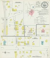
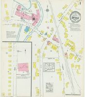
Sanborn fire insurance maps are a rich source of historic data on the urban built environment of North America during the 19th and early 20th centuries. The atlases were created for the purpose of underwriting fire insurance policies, which depended u...
Alternative Title:
Mar. 1912, Darien, Conn.
Description:
"4653 (3 sheets)."
Subject (Geographic):
Darien (Conn.)--Maps
Subject (Name):
Library of Congress Stamp
Subject (Topic):
Fire risk assessment--Connecticut--Darien--Maps and Real property--Connecticut--Darien--Maps
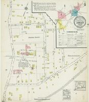
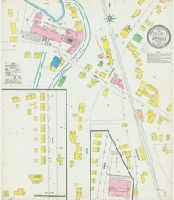
Sanborn fire insurance maps are a rich source of historic data on the urban built environment of North America during the 19th and early 20th centuries. The atlases were created for the purpose of underwriting fire insurance policies, which depended u...
Alternative Title:
Nov. 1920, Darien, Conn.
Description:
"3414 (4 sheets)."
Subject (Geographic):
Darien (Conn.)--Maps
Subject (Name):
Library of Congress Stamp
Subject (Topic):
Fire risk assessment--Connecticut--Darien--Maps and Real property--Connecticut--Darien--Maps
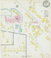
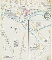
Sanborn fire insurance maps are a rich source of historic data on the urban built environment of North America during the 19th and early 20th centuries. The atlases were created for the purpose of underwriting fire insurance policies, which depended u...
Alternative Title:
Jan. 1928, Darien, Conn.
Description:
"(3457) (10 sheets)."
Subject (Geographic):
Darien (Conn.)--Maps
Subject (Name):
Library of Congress Stamp
Subject (Topic):
Fire risk assessment--Connecticut--Darien--Maps and Real property--Connecticut--Darien--Maps
Sanborn fire insurance maps are a rich source of historic data on the urban built environment of North America during the 19th and early 20th centuries. The atlases were created for the purpose of underwriting fire insurance policies, which depended u...
Description:
"5317."
Subject (Geographic):
Killingly (Conn. : Town)--Maps
Subject (Name):
Library of Congress Stamp
Subject (Topic):
Fire risk assessment--Connecticut--Killingly (Town)--Maps and Real property--Connecticut--Killingly (Town)--Maps
Sanborn fire insurance maps are a rich source of historic data on the urban built environment of North America during the 19th and early 20th centuries. The atlases were created for the purpose of underwriting fire insurance policies, which depended u...
Description:
"6394."
Subject (Geographic):
Killingly (Conn. : Town)--Maps
Subject (Name):
Library of Congress Stamp
Subject (Topic):
Fire risk assessment--Connecticut--Killingly (Town)--Maps and Real property--Connecticut--Killingly (Town)--Maps
Sanborn fire insurance maps are a rich source of historic data on the urban built environment of North America during the 19th and early 20th centuries. The atlases were created for the purpose of underwriting fire insurance policies, which depended u...
Alternative Title:
Mar. 1917, Dayville, Conn.
Description:
"1776 (2 sheets)."
Subject (Geographic):
Killingly (Conn. : Town)--Maps
Subject (Name):
Library of Congress Stamp
Subject (Topic):
Fire risk assessment--Connecticut--Killingly (Town)--Maps and Real property--Connecticut--Killingly (Town)--Maps
Sanborn fire insurance maps are a rich source of historic data on the urban built environment of North America during the 19th and early 20th centuries. The atlases were created for the purpose of underwriting fire insurance policies, which depended u...
Alternative Title:
Aug. 1927, Dayville, Conn.
Description:
"(3246) (3 sheets)."
Subject (Geographic):
Killingly (Conn. : Town)--Maps
Subject (Name):
Library of Congress Stamp
Subject (Topic):
Fire risk assessment--Connecticut--Killingly (Town)--Maps and Real property--Connecticut--Killingly (Town)--Maps
Sanborn fire insurance maps are a rich source of historic data on the urban built environment of North America during the 19th and early 20th centuries. The atlases were created for the purpose of underwriting fire insurance policies, which depended u...
Alternative Title:
Aug. 1884, Deep River, Conn.
Description:
"2 sheets."
Subject (Geographic):
Deep River (Conn. : Town)--Maps
Subject (Name):
Library of Congress Stamp
Subject (Topic):
Fire risk assessment--Connecticut--Deep River (Town)--Maps and Real property--Connecticut--Deep River (Town)--Maps
Sanborn fire insurance maps are a rich source of historic data on the urban built environment of North America during the 19th and early 20th centuries. The atlases were created for the purpose of underwriting fire insurance policies, which depended u...
Alternative Title:
Aug. 1889, Deep River, Conn.
Description:
"(3476). 2 sheets. "
Subject (Geographic):
Deep River (Conn. : Town)--Maps
Subject (Name):
Library of Congress Stamp
Subject (Topic):
Fire risk assessment--Connecticut--Deep River (Town)--Maps and Real property--Connecticut--Deep River (Town)--Maps