Skip to search
Skip to main content
Skip to first result
Search
You Searched For
Format
cartographic
Genre
Maps.
Language
Italian
Search Results
Creator:
Published / Created:
1781
Call Number:
BrSides Folio 2017 19
Image Count:
1
Resource Type:
Maps, Atlases & Globes
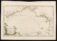
Description:
Bar scale given in "Leghe marine Francesi ed Inglesi di 20 al grado."
Publisher:
[publisher not identified],
Subject (Geographic):
Africa, Central--Maps--Early works to 1800. and Africa, West--Maps--Early works to 1800.
Subject (Topic):
Coasts--Africa, Central--Maps--Early works to 1800. and Coasts--Africa, West--Maps--Early works to 1800.
Found in:
Beinecke Rare Book and Manuscript Library > Carta della bassa Guinea tra il capo tres puntas, e l'equatore / di Mr. d'Anville.
Creator:
Published / Created:
[1710?]
Call Number:
1973 Folio 18
Image Count:
1
Resource Type:
Maps, Atlases & Globes
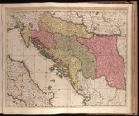
Description:
Backed with paper. Ms. no. "77" in upper right corner. Sheet measures 53.6 x 62.5 cm. No. 71 of 87 maps bound together.
Publisher:
Gerardum et Leonardum Valk,
Subject (Geographic):
Balkan Peninsula--Maps--Early works to 1800.
Subject (Name):
Valck, Leonard, 1675-1746.
Found in:
Beinecke Rare Book and Manuscript Library > Dalmatia, Sclavonia, Croatia, Bosnia, Servia, et Istria [cartographic material] : distributa in singulares ditiones et diœceses, una cum Republica Ragusana, et circumjacentibus regionibus, Hungaria, Venetiis, statu ecclesiastico, Napoli et Macedonia / Venundantur per Gerardum et Leonardum Valk, cum Priv.
Creator:
Published / Created:
1647?]
Call Number:
1973 Folio 18
Image Count:
1
Resource Type:
Maps, Atlases & Globes
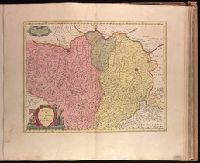
Alternative Title:
Dvcato di Parma et di Piacenza
Description:
Bar scale given in "miglia sette."
Publisher:
Joan Blaeu,
Subject (Geographic):
Parma (Italy : Province)--Maps--Early works to 1800. and Piacenza (Italy : Province)--Maps--Early works to 1800.
Found in:
Beinecke Rare Book and Manuscript Library > Ducato di Parma et di Piacenza [cartographic material].
Creator:
Published / Created:
1647?]
Call Number:
1973 Folio 18
Image Count:
1
Resource Type:
Maps, Atlases & Globes
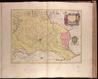
Alternative Title:
Dvcato ouero Territorio di Milano
Description:
Backed with paper. Ms. no. "73" in upper right corner. Sheet measures 53.6 x 63.0 cm. No. 68 of 87 maps bound together.
Publisher:
Joan Blaeu,
Subject (Geographic):
Milan (Italy : Province)--Maps--Early works to 1800.
Found in:
Beinecke Rare Book and Manuscript Library > Ducato ouero Territorio di Milano [cartographic material].
Published / Created:
[1852?]
Call Number:
40 V55 1850A
Image Count:
1
Resource Type:
Maps, Atlases & Globes
Description:
Appears in Giuseppe La Farina's history of Italy published 1851-1852 by Societa editrice italiana.
Publisher:
Dr. Francesco Vallardi ,
Subject (Geographic):
Venice (Italy : Province)--Maps.
Subject (Name):
Casa editrice dr. Francesco Vallardi.
Found in:
Beinecke Rare Book and Manuscript Library > Governo di Venezia, provincia de Venezia.
Creator:
Published / Created:
1647?]
Call Number:
1973 Folio 18
Image Count:
1
Resource Type:
Maps, Atlases & Globes
Alternative Title:
Bellvnese con il Feltrino
Description:
Backed with paper. Ms. no. "70" in upper right corner. Sheet measures 53.6 x 63.3 cm. No. 65 of 87 maps bound together.
Publisher:
Joan Blaeu,
Subject (Geographic):
Belluno (Italy : Province)--Maps--Early works to 1800.
Found in:
Beinecke Rare Book and Manuscript Library > Il Bellunese con il Feltrino [cartographic material].
Creator:
Published / Created:
1647?]
Call Number:
1973 Folio 18
Image Count:
1
Resource Type:
Maps, Atlases & Globes
Description:
Backed with paper. Ms. no. "69" in upper right corner. Sheet measures 53.5 x 62.5 cm. No. 64 of 87 maps bound together.
Publisher:
Joan Blaeu,
Subject (Geographic):
Italy, Northern--Maps--Early works to 1800. and Veneto (Italy)--Maps--Early works to 1800.
Found in:
Beinecke Rare Book and Manuscript Library > Il Cadorino [cartographic material].
Creator:
Published / Created:
1778
Call Number:
73 1778
Image Count:
1
Resource Type:
Maps, Atlases & Globes
Description:
Appears in the Zatta's Atlante novissimo. 1779-85. v.4.
Publisher:
Presso Antonio Zatta,
Subject (Geographic):
Canada--Maps--Early works to 1800., Greenland--Maps--Early works to 1800., and Hudson Bay Region--Maps--Early works to 1800.
Subject (Name):
Giuliani, G., Pitteri, Giovanni Marco, 1702-1786., and Zatta, Antonio, active 1757-1797. Atlante Novissimo.
Found in:
Beinecke Rare Book and Manuscript Library > La Baja d'Hudson, terra di Labrador e Groenlandia con le isole adiacenti di nuova projezione / presso Antonio Zatta, G. Giuliani, inc., G. Pitteri, ser.
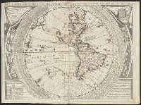
Creator:
Published / Created:
1691 or 1695]
Call Number:
70 169XC
Image Count:
1
Resource Type:
Maps, Atlases & Globes
Description:
"Dedicato all illustrissimo, et eccellentissimo Signore Andrea Marcello, Senatore Amplissimo, e Fratello dell' Eccellentiss: Sigr. Federico, Procuratore di S. Marco".
Publisher:
s.n.,
Subject (Geographic):
Western Hemisphere--Maps--Early works to 1800.
Subject (Name):
Coronelli, Vincenzo, 1650-1718. Atlante Veneto., Karpinski, Louis Charles,--1878-1956--Ownership., Karpinski-von Wieser Map Collection., Sacro Bosco, Joannes de, active 1230., and Wieser, Franz,--Ritter von,--1848-1923--Ownership.
Found in:
Beinecke Rare Book and Manuscript Library > Planisfero del mondo nuovo / descritto dal P. Coronelli, cosmografo publico.
Branch:v1.68.6 ,Deployed:2025-07-02T08:09:28-04:00