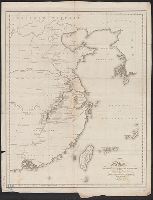
From Cary's new universal atlas ... London : Printed for J. Cary, 1808., Ms. no. on verso: 26. Hand col. Sheet measures 52.1 x 68.2 cm. Cross Collection no. 106., Prime meridian: Greenwich., and Relief shown pictorially.
Publisher:
J. Cary,
Subject (Geographic):
China--Maps
Subject (Name):
Cary, John, ca. 1754-1835. Cary's new universal atlas
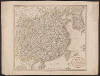
From Cary's new universal atlas ... London : Printed for J. Cary, 1808., Label on verso: 46. Hand col. Sheet measures 54.2 x 63.8 cm., Prime meridian: Greenwich., and Relief shown pictorially.
Publisher:
J. Cary,
Subject (Geographic):
China--Maps
Subject (Name):
Cary, John, ca. 1754-1835. Cary's new universal atlas
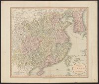
Four-track series., Map of Asia, and New map of Asia and the Chinese empire as they are to-day :
Description:
"Printed for the New York Central's 'Four-Track Series. No. 28'", From panel-title: Issued by the Passenger Department of the New York Central and Hudson River R.R. Copyright 1901 by Geo. H. Daniels General Passenger Agent.", and Recto: advertisements and schedules for trains with text and ill.
Publisher:
Rand, McNally & Co. ,
Subject (Geographic):
China--Maps, Japan--Maps, and Korea--Maps
Subject (Name):
New York Central and Hudson River Railroad Company
Subject (Topic):
Transportation--China--Maps, Transportation--Japan--Maps, and Transportation--Korea--Maps
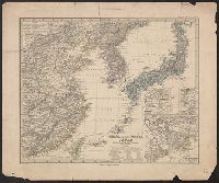
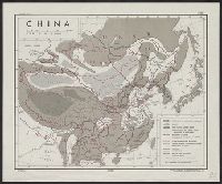
China (östlicheTheil), Korea und Japan im Massstab 1:7.500.000
Description:
From Stieler's Hand-Atlas., In upper left: Stieler's Hand Atlas, N⁰ 65., Insets: Schanghai und Umgebung -- Jedo und Umgebung -- Der Canton-Strom und seine Umgebung., Prime meridians: Greenwich, Ferro, Paris., and Relief shown by hachures.
National Geographic Society (U.S.). Cartographic Section
Published / Created:
1945
Call Number:
56 1945
Container / Volume:
BRBL_00296
Image Count:
1
Resource Type:
Maps, Atlases & Globes
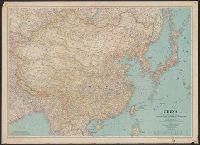
Description:
"June 1945.", Accompanied by: Index to Map of China / prepared in the Cartographic Department of the National Geographic Society for the National Geographic Society Magazine with 7,986 place names (35 p. ; 20 cm.)., and Relief shown by shading and spot heights.
Publisher:
Lithographed by A. Hoen and Co., and National Geographic Society ;
National Geographic Society (U.S.). Cartographic Section
Published / Created:
1945
Call Number:
56 1945
Container / Volume:
BRBL_00296
Image Count:
1
Resource Type:
Maps, Atlases & Globes
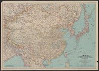
Description:
"June 1945.", Accompanied by: Index to Map of China / prepared in the Cartographic Department of the National Geographic Society for the National Geographic Society Magazine with 7,986 place names (35 p. ; 20 cm.)., and Relief shown by shading and spot heights.
Publisher:
Lithographed by A. Hoen and Co., and National Geographic Society ;
National Geographic Society (U.S.). Cartographic Section
Published / Created:
1945
Call Number:
56 1945
Container / Volume:
BRBL_00296
Image Count:
1
Resource Type:
Maps, Atlases & Globes
Description:
"June 1945.", Accompanied by: Index to Map of China / prepared in the Cartographic Department of the National Geographic Society for the National Geographic Society Magazine with 7,986 place names (35 p. ; 20 cm.)., and Relief shown by shading and spot heights.
Publisher:
Lithographed by A. Hoen and Co., and National Geographic Society ;