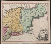
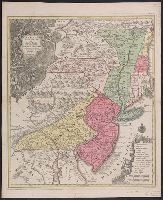
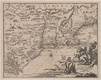
1st state. Cross collection no. 20. No. 3 of 3 maps mounted on linen., Appeared in Arnoldus Montanus's De Nieuwe en onbekende weereld., Includes ill., and Relief shown pictorially.
Publisher:
Jacob von Meurs?,
Subject (Geographic):
NewEngland--Maps--Early works to 1800
Subject (Name):
Montanus, Arnoldus, 1625?-1683. Nieuwe en onbekende weereld
Appeared in Arnoldus Montanus's De Nieuwe en onbekende weereld., Copy 2: 1st state. Uncolored. Mounted on linen. Dimensions: 29 x 37 cm., on sheet 36 x 44 cm. Verso: Stamped "Yale"., Includes ill., and Relief shown pictorially.
Publisher:
Jacob von Meurs?,
Subject (Geographic):
NewEngland--Maps--Early works to 1800
Subject (Name):
Montanus, Arnoldus, 1625?-1683. Nieuwe en onbekende weereld
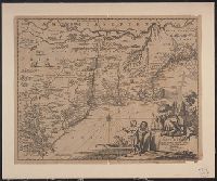
Appears in the author's Descriptionis Ptolemaicae augmentum. 1597., Covers the Atlantic coast of North America from Nova Scotia to Virginia., Has watermark., In upper right: 17., and Relief shown pictorially.
Publisher:
J. Bogard],
Subject (Geographic):
Atlantic Coast (U.S.)--Maps--Early works to 1800
Subject (Name):
Bogard, Jean, d. ca. 1634 and Wytfliet, Corneille. Descriptionis Ptolemaicae augmentum
Subject (Topic):
Coasts--Maritime Provinces--Maps--Early works to 1800
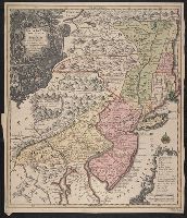
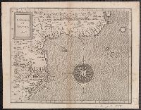
Appears in various eds. of Atlas geographicus maior., Includes German text relating to English and French territorial claims., Neat lines measures 45.8 x 50.8 cm. on sheet 50 x 57.5 cm. Ms. note on verso: No. 151, Nord America nach d'Anville. Franklin Collection no. 131 1756-9., Place names and descriptive notes in English., Prime meridian: Ferro and London., and Relief shown pictorially.
Publisher:
[Homann Erben],
Subject (Geographic):
North America--Maps--Early works to 1800 and United States--History--French and Indian War, 1755-1763--Maps--Early works to 1800
Subject (Name):
Anville, Jean Baptiste Bourguignon d', 1697-1782 and Homann Erben (Firm). Atlas geographicus maior
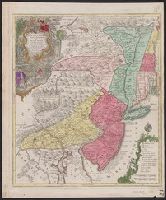
Appears in various eds. of Atlas geographicus maior., Includes German text relating to English and French territorial claims., Place names and descriptive notes in English., Prime meridian: Ferro and London., Relief shown pictorially., and Sheet measures 47.5 x 51 cm.
Publisher:
[Homann Erben],
Subject (Geographic):
North America--Maps--Early works to 1800. and United States--History--French and Indian War, 1755-1763--Maps--Early works to 1800.
Subject (Name):
Anville, Jean Baptiste Bourguignon d', 1697-1782. and Homann Erben (Firm). Atlas geographicus maior.