The English pilot: describing the West-India navigation, from Hudson's-Bay to the river Amazones
Image Count:
1
Subject (Geographic):
Africa --Maps --Early works to 1800, Antarctic Ocean --Maps, Atlantic Ocean --Maps --Early works to 1800, Europe --Maps --Early works to 1800, North America --Maps --Early works to 1800, and South America --Maps --Early works to 1800
Subject (Topic):
Navigation --Early works to 1800, Pilot guides --Atlantic Coast (U.S.) --Early works to 1800, and Pilot guides --Caribbean Area --Early works to 1800
Collection Created:
London : Printed for W. and J. Mount, T. Page and son, on Tower-Hill, MDCCLX [1760]
The English pilot: describing the West-India navigation, from Hudson's-Bay to the river Amazones
Image Count:
2
Subject (Geographic):
Africa --Maps --Early works to 1800, Antarctic Ocean --Maps, Atlantic Ocean --Maps --Early works to 1800, Europe --Maps --Early works to 1800, North America --Maps --Early works to 1800, and South America --Maps --Early works to 1800
Subject (Topic):
Navigation --Early works to 1800, Pilot guides --Atlantic Coast (U.S.) --Early works to 1800, and Pilot guides --Caribbean Area --Early works to 1800
The English pilot: describing the West-India navigation, from Hudson's-Bay to the river Amazones
Image Count:
1
Resource Type:
Maps, Atlases & Globes
Subject (Geographic):
Africa --Maps --Early works to 1800, Antarctic Ocean --Maps, Atlantic Ocean --Maps --Early works to 1800, Europe --Maps --Early works to 1800, North America --Maps --Early works to 1800, and South America --Maps --Early works to 1800
Subject (Topic):
Navigation --Early works to 1800, Pilot guides --Atlantic Coast (U.S.) --Early works to 1800, and Pilot guides --Caribbean Area --Early works to 1800
Collection Created:
London : Printed for W. and J. Mount, T. Page and son, on Tower-Hill, MDCCLIX [1759]
The English pilot: describing the West-India navigation, from Hudson's-Bay to the river Amazones
Image Count:
1
Description:
Imperfect: mutilated with slight loss of image.
Subject (Geographic):
Africa --Maps --Early works to 1800, Antarctic Ocean --Maps, Atlantic Ocean --Maps --Early works to 1800, Europe --Maps --Early works to 1800, North America --Maps --Early works to 1800, and South America --Maps --Early works to 1800
Subject (Topic):
Navigation --Early works to 1800, Pilot guides --Atlantic Coast (U.S.) --Early works to 1800, and Pilot guides --Caribbean Area --Early works to 1800
Collection Created:
London : Printed for Thomas Page, William and Fisher Mount, in Postern-Row on Tower-hill, MDCCXXV [1725]
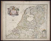
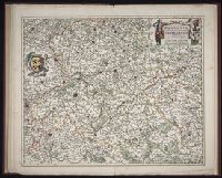
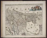
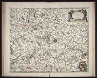
Twenty four new and accurate maps of the several parts of Europe ... : all (except the last) new
Image Count:
1
Alternative Title:
Europe in particular
Description:
In pencil on verso: 2.
Subject (Geographic):
Europe --Maps --Early works to 1800
Subject (Name):
Barker, B. (Benjamin), d. 1764, bookseller, Clements, Henry, d. 1719, bookseller, King, Charles, d. 1735, bookseller, Nicholson, John, d. ca. 1717, bookseller, Parker, Richard, fl. 1692-1725, bookseller, and Tooke, Benjamin, d. 1716, bookseller
Subject (Topic):
Atlases --Early works to 1800
Collection Created:
[London] : Sold by J. Nicholson at the King’s-Arms in Little Britain, Benj. Barker and Charles King ..., Benj. Tooke ..., Hen. Clements ..., R. Parker and Ralph Smith under the Royal-Exchange ..., [1715?]
Also appeared in Faden's [General atlas. London : William Faden, 1811?]., Hand-coloring of political borders differ from 1982 Folio 10, no. 20., No. 20 of 43 maps bound together in composite atlas., No. 21 of 43 maps bound together in composite atlas., Relief shown pictorially., and Scale [ca. 1:2,150,000].
Publisher:
William Faden
Subject (Geographic):
Europe --Maps --Early works to 1800, Germany --Administrative and political divisions --Maps --Early works to 1800, and Germany --Maps --Early works to 1800