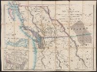
Cut and mounted on linen; "Wyld's new maps" advertisement on verso., Forts; boundaries; Indians; proposed railway; gold; coal., and Insets: Strait of San Juan de Fuca. -- on an enlarged scale. -- 7.4 x 8 cm.; British possessions in North America. -- scale [1:34
Publisher:
James Wyld,
Subject (Geographic):
British Columbia--Maps and Canada--Boundaries--United States--Maps
Subject (Topic):
Coal mines and mining--North America, Western--Maps, Gold mines and mining--British Columbia--Maps, and Indians--North America, Western--Maps
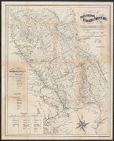
"Entered according to the Act of Congress in the year 1862 by Gustavus Epner in the Clerks Office of the District Court of the North Dist. of California." and Inset: Routes of comunication with the Cariboo Mines. -- Tables showing mileages along Douglas & Ft.
Publisher:
Epner,
Subject (Geographic):
British Columbia--19th century--Maps
Subject (Name):
Britton & Co
Subject (Topic):
Distances--British Columbia--Maps and Gold mines and mining--British Columbia--Maps