Search
You Searched For
Search Results
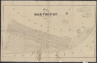
- Creator:
- Groesbeck, Jno. D. (John D.)
- Published / Created:
- 1854]
- Call Number:
- 796 G139 1838
- Container / Volume:
- BRBL_00527
- Image Count:
- 1
- Resource Type:
- Maps, Atlases & Globes
- Found in:
- Beinecke Rare Book and Manuscript Library > Map of the city of Galveston : situated on the east end of Galveston Island, Texas / surveyed and drawn by Jno. D. Groesbeck, civil engineer ; L.H. Bradford & Co.'s lith.
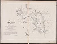
- Creator:
- Gray, A. B. (Andrew Belcher), 1820-1862
- Published / Created:
- 1842?]
- Call Number:
- 796fab Sa13 1842I
- Container / Volume:
- BRBL_00530
- Image Count:
- 1
- Resource Type:
- Maps, Atlases & Globes
- Found in:
- Beinecke Rare Book and Manuscript Library > Map of the river Sabine from Logan's Ferry to 32nd degree of north latitude : shewing the boundary between the United States of America and the Republic of Texas between said points, as marked and laid down by survey in 1841, under the direction of the Jo
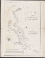
- Creator:
- Lee, Thomas Jefferson, 1808-1891
- Published / Created:
- 1842?]
- Call Number:
- 796fab Sa13 1842J
- Container / Volume:
- BRBL_00530
- Image Count:
- 1
- Resource Type:
- Maps, Atlases & Globes
- Found in:
- Beinecke Rare Book and Manuscript Library > Sabine Pass and mouth of the river Sabine in the sea / surveyed under the direction of Major J.D. Graham, U.S. Top.l Engineers ; by Lieut. T.J. Lee, U.S. Top.l Engineers and Cap.t P.J. Pillans, Texan Army, attached to the Joint Commission for marking the