
You Searched For
1 - 8 of 8
Search Results


- Creator:
- Great Britain. Hydrographic Dept
Stokes, J. Lort (John Lort), 1811-1885 - Published / Created:
- Aug. 16th. 1852 [i.e. 1865]
- Call Number:
- 26cea 1851B
- Container / Volume:
- BRBL_00023
- Image Count:
- 1
- Resource Type:
- Maps, Atlases & Globes
- Description:
- "Corrections to ... Mar. 65.", Chart "2142.", and Chart of coast from Barriga Point to Jervis Bay with relief shown by hachures, bathymetric soundings and spot heights.
- Publisher:
- Published according to Act of Parliament at the Hydrographic Office of The Admiralty : and Sold by J.D. Potter Agent for the Admiralty charts 31 Poultry,
- Subject (Geographic):
- Australia, Southeastern--Maps
- Found in:
- Beinecke Rare Book and Manuscript Library > Australia east coast. Sheet II, Barriga Point to Jervis Bay / from a running survey by Captn. J. Lort Stokes ... 1851 ; engraved by J. & C. Walker.
3.

- Creator:
- Great Britain. Hydrographic Dept
Potter, J. D - Published / Created:
- Aug. 16th 1852 [i.e. 1865]
- Call Number:
- 26cea 1851C
- Container / Volume:
- BRBL_00023
- Image Count:
- 1
- Resource Type:
- Maps, Atlases & Globes
- Description:
- "Additions to ... Mar. 65.", Chart no. "2143.", and Chart of coast from Jervis Bay to Broken Bay with relief shown by hachures, bathymetric soundings and spot heights.
- Publisher:
- Published according to Act of Parliament at the Hydrographic Office of the Admiralty : and Sold by J.D. Potter for the Admiralty charts 31 Poultry,
- Subject (Geographic):
- Australia, Southeastern--Maps
- Found in:
- Beinecke Rare Book and Manuscript Library > Australia east coast. Sheet III, Jervis Bay to Broken Bay / from a running survey by Captn. J. Lort Stokes ... 1851.
4.

- Creator:
- Great Britain. Hydrographic Dept
Potter, J. D - Published / Created:
- Aug. 16th. 1852 [i.e. 1862]
- Call Number:
- 26cea 1851D
- Container / Volume:
- BRBL_00023
- Image Count:
- 1
- Resource Type:
- Maps, Atlases & Globes
- Description:
- "2144"., "Corrections Sept. 1862.", and Chart of coast from Broken Bay to Sugarloaf Point with relief shown by hachures, bathymetric soundings and spot heights.
- Publisher:
- Published according to Act of Parliament at the Hydrographic Office of The Admiralty : and Sold by J.D. Potter Agent for the Admiralty charts 31 Poultry,
- Subject (Geographic):
- Australia, Southeastern--Maps
- Found in:
- Beinecke Rare Book and Manuscript Library > Australia east coast. Sheet IV, Broken Bay to Sugarloaf Point / from a running survey by Captn. J. Lort Stokes ... 1851 ; engraved by J. & C. Walker.

- Creator:
- Evans, F. J. (Frederick J.)
Great Britain. Hydrographic Dept
J. & C. Walker (Firm)
Potter, J. D. (John D.)
Washington Capt - Published / Created:
- Decr. 12th 1860.
- Call Number:
- 26cea 1860
- Container / Volume:
- BRBL_00023
- Image Count:
- 1
- Resource Type:
- Maps, Atlases & Globes
- Alternative Title:
- Coral Sea and Great Barrier Reefs shewing the inner and outer routes to Torres Strait
- Description:
- "2764"., Imperfect: Mutilated with loss of tex, Nautical chart of the Great Barrier Reef and the Coral Sea showing routes to the Torres Strait. Relief is shown by hachures and spot heights. Depth shown by bathymetric soundings., and On verso: XXVIII.
- Publisher:
- Published at the Admiralty ... under the superintendence of Captn. Washington R.N., F.R.S. Hydrographer ; Sold by J.D. Potter, agent for the Admiralty charts, 31 Poultry and 11 King Street, Tower Hill,
- Subject (Geographic):
- Coral Sea--Maps and Great Barrier Reef (Qld.)--Maps
- Found in:
- Beinecke Rare Book and Manuscript Library > Australia, Coral Sea and Great Barrier Reefs shewing the inner and outer routes to Torres Strait. Sheet 2 : from the surveys of Captains Blackwood, Owen Stanley, and Yule, R.N., 1842-50 : the outer detached reef's from Captains Flinders and Denham, Royal
- Creator:
- Great Britain. Hydrographic Dept
- Published / Created:
- 1863
- Call Number:
- 5735 1861
- Container / Volume:
- BRBL_00734
- Image Count:
- 1
- Resource Type:
- Maps, Atlases & Globes
- Alternative Title:
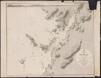
- Nagasaki Harbour
- Description:
- Chart number "2415" in lower right hand corner. and Drawn by E. J. Powell.
- Publisher:
- The Admiralty,
- Subject (Geographic):
- Nagasaki-shi (Japan)--Harbors--Maps
- Subject (Name):
- Powell, E.J
- Subject (Topic):
- Nautical charts--Japan--Nagasaki Harbour
- Found in:
- Beinecke Rare Book and Manuscript Library > Japan Kiusiu Island, West Coast. Nagasaki Harbour, 1861 / engraved by Davies & Powell.
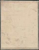
- Creator:
- Davidson, George, 1825-1911. asn CU-BANC
Great Britain. Hydrographic Dept
J. & C. Walker (Firm) - Published / Created:
- [1856?-186-?]
- Call Number:
- 23cea 1856
- Collection Title:
- Pacific Ocean / Hydrographic Office ; Engraved by J. & C. Walker.
- Container / Volume:
- BRBL_00021
- Image Count:
- 1
- Resource Type:
- Maps, Atlases & Globes
- Alternative Title:
- [Nautical chart] ; no. 2464 and Great Britain. Hydrographic Dept. Nautical chart ; no. 2464.
- Description:
- 1. Kamchatka to Chusan Islands. -- 2. Behring Strait to 30⁰N. lat. -- 3. Cook River, Each sheet includes diagram showing sheet arrangement., Light houses added by hand in color., Relief shown by hachures and spot heights., and Shows lines of magnetic declination.
- Publisher:
- the Admiralty,
- Subject (Geographic):
- Pacific Ocean--Maps
- Subject (Topic):
- Nautical charts--Pacific Ocean
- Found in:
- Beinecke Rare Book and Manuscript Library > Sandwich Islands to New Caledonia.
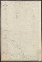
- Creator:
- Great Britain. Hydrographic Dept
J. & C. Walker (Firm) - Published / Created:
- [1866?]
- Call Number:
- 23cea J328 1861
- Image Count:
- 1
- Resource Type:
- Maps, Atlases & Globes
- Description:
- "Corrections Sept. 1862. March [18]64. Jan. [18]65. May [18]66."
- Publisher:
- The Admiralty,
- Subject (Geographic):
- Java Sea (Indonesia)--Maps
- Subject (Topic):
- Nautical charts--Java Sea
- Found in:
- Beinecke Rare Book and Manuscript Library > Western part of the Java Sea : from Lucipara I. to Sunda Strait and Batavia, corrected to 1861 / engraved by J. & C. Walker.