
You Searched For
1 - 10 of 10
Search Results


- Creator:
- Anville, Jean Baptiste Bourguignon d', 1697-1782
- Published / Created:
- 1779
- Call Number:
- 90 1779
- Container / Volume:
- BRBL_00661
- Image Count:
- 2
- Resource Type:
- Maps, Atlases & Globes
- Description:
- Both sheets backed with paper., Includes text and historical notes., Inset: Chart of Falkland Islands named by the French Malouine Islands and discovered by Hawkins in the year 1593., Outline color., Prime meridian: Ferro., Relief sh, and Watermarks on both sheets.
- Publisher:
- Sayer and Bennett,
- Subject (Geographic):
- Falkland Islands--Maps--Early works to 1800 and South America--Maps--Early works to 1800
- Subject (Name):
- Robert Sayer and John Bennett (Firm)
- Found in:
- Beinecke Rare Book and Manuscript Library > A map of South America containing Tierra-Firma, Guayana, New Granada, Amazonia, Brasil, Peru, Paraguay, Chaco, Tucuman, Chili and Patagonia [cartographic material] : from Mr. d'Anville, with several improvements and additions, and the newest discoveries /

- Creator:
- Dunn, Samuel, d. 1794
- Call Number:
- 71 1776
- Container / Volume:
- BRBL_00687
- Image Count:
- 1
- Resource Type:
- Maps, Atlases & Globes
- Description:
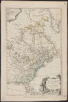
- According to Sellers and Van Ee, this map is the 2nd state., At lower margin "London, printed for R. Sayer & J. Bennett, map & sea chartseller, no. 53, Fleet Street, as the act directs, Augst. 17th 1776., Includes a list of British colonies and territories., and Relief shown pictorially.
- Publisher:
- [Printed and sold by R. Sayer and J. Bennett, map and print seller, no. 53, Fleet St. 1776]
- Subject (Geographic):
- North America--Maps--Early works to 1800
- Subject (Name):
- Carver, Jonathan, 1710-1780, Jefferys, Thomas, d. 1771. American atlas, and Robert Sayer and John Bennett (Firm)
- Found in:
- Beinecke Rare Book and Manuscript Library > A map of the British Empire, in North America / by Samuel Dunn, mathematician, improved from the surveys of Capt. Carver.
- Creator:
- Dunn, Samuel, d. 1794
- Published / Created:
- Augst. 17th. 1776.
- Call Number:
- 755 1776F
- Container / Volume:
- BRBL_00430
- Image Count:
- 1
- Resource Type:
- Maps, Atlases & Globes
- Publisher:
- Printed for R. Sayer & J. Bennett, map & sea chartsellers, no. 53 Fleet Street, as the act directs,
- Subject (Geographic):
- Great Britain--Colonies--America--Maps--Early works to 1800 and North America--Maps--Early works to 1800
- Subject (Name):
- Robert Sayer and John Bennett (Firm)
- Found in:
- Beinecke Rare Book and Manuscript Library > A map of the British empire in North America / by Samuel Dunn, mathematician, improved from the surveys of Capt. Carver.
5.

- Creator:
- Pownall, Thomas, 1722-1805
- Published / Created:
- 1777
- Call Number:
- 71 1777B
- Container / Volume:
- BRBL_00365
- Image Count:
- 1
- Resource Type:
- Maps, Atlases & Globes
- Description:
- Includes historical notes, insets of "A particular map of Baffin and Hudson's Bay" and "The passage by land to California," and articles 4-7, 9, 12, 13, and 20 of the "definitive treaty.", Prime meridian: London and Ferro., Relief shown pictorially., and Stamped
- Publisher:
- Printed for Robt. Sayer and Jno. Bennett,
- Subject (Geographic):
- North America--Maps--Early works to 1800
- Subject (Name):
- Robert Sayer and John Bennett (Firm)
- Subject (Topic):
- British--America--Maps--Early works to 1800
- Found in:
- Beinecke Rare Book and Manuscript Library > A new and correct map of North America, with the West India Islands : divided according to the last treaty of peace, concluded at Paris. 10th. Feby. 1763, wherein are particularly distinguished, the several provinces and colonies, which compose the Britis

- Creator:
- Pownall, Thomas, 1722-1805
- Published / Created:
- [1783?]
- Call Number:
- 71 1783B
- Container / Volume:
- BRBL_00366
- Image Count:
- 2
- Resource Type:
- Maps, Atlases & Globes
- Description:
- Date in printer statement, in lower right margin: 15th July 1779., Includes notes and insets of "A particular map of Baffin and Hudson's Bay" and "The passage by land to California ....", Prime meridian: London and Ferro., and Relief shown pictorially.
- Publisher:
- Printed for Robt. Sayer and Jno. Bennett,
- Subject (Geographic):
- North America--Maps--Early works to 1800
- Subject (Name):
- Robert Sayer and John Bennett (Firm)
- Subject (Topic):
- British--America--Maps--Early works to 1800
- Found in:
- Beinecke Rare Book and Manuscript Library > A new and correct map of North America, with the West India Islands : divided according to the preliminary articles of peace, concluded at Versailles, 20 Jan. 1783, wherein are particularly distinguished, the United States & the several provinces and colo

- Creator:
- Jefferys, Thomas, -1771
- Published / Created:
- 15 June 1775.
- Call Number:
- 732 1775
- Container / Volume:
- BRBL_00727
- Image Count:
- 1
- Resource Type:
- Maps, Atlases & Globes
- Description:
- "Published according to act of Parliament by Thos. Jefferys ... ", Meridian: Ferro., Relief shown pictorially. Depths shown by soundings., and Upper right corner: VII.
- Publisher:
- Printed & Sold by R. Sayer & J. Bennett, No. 53 in Fleet Street,
- Subject (Geographic):
- Cape Breton Island (N.S.)--Maps--Early works to 1800, New England--Maps--Early works to 1800, and Nova Scotia--Maps--Early works to 1800
- Subject (Name):
- Robert Sayer and John Bennett (Firm)
- Found in:
- Beinecke Rare Book and Manuscript Library > A new map of Nova Scotia, and Cape Breton Island : with the adjacent parts of New England and Canada, composed from a great number of actual surveys; and other materials regulated by many new astronomical observations of the longitude as well as latitude

- Creator:
- Carver, Jonathan, 1710-1780
- Published / Created:
- 16th Feb. 1776.
- Call Number:
- 734 1776A
- Container / Volume:
- BRBL_00727
- Image Count:
- 1
- Resource Type:
- Maps, Atlases & Globes
- Description:
- From Jefferys's The American atlas ... London : Printed and sold by R. Sayer and J. Bennett, 1776., Insets: A particular survey of the Isles of Montreal -- The city of Quebec -- Course of the river St. Laurence, from La Valterie to Quebec -- Plan of Montreal, or Víllemarie., Prime meridian: London., Relief shown pictorially., and Watermark.
- Publisher:
- Printed for Robt. Sayer and John Bennett,
- Subject (Geographic):
- Québec (Province)--Maps--Early works to 1800
- Subject (Name):
- Jefferys, Thomas, -1771. American atlas and Robert Sayer and John Bennett (Firm)
- Found in:
- Beinecke Rare Book and Manuscript Library > A new map of the province of Quebec : according to the Royal Proclamation, of the 7th of October 1763 / from the French surveys connected with those made after the war, by Captain Carver, and other officers, in His Majesty's service.

- Creator:
- Carver, Jonathan, 1710-1780
- Published / Created:
- 16th February 1776.
- Call Number:
- 131 1776-6
- Container / Volume:
- BRBL_00011
- Image Count:
- 1
- Resource Type:
- Maps, Atlases & Globes
- Description:
- From Jefferys's The American atlas ... London : Printed and sold by R. Sayer and J. Bennett, 1776. and Insets: A particular survey of the Isles of Montreal -- The city of Quebec -- Course of the river St. Laurence, from La Valterie to Quebec -- Plan of Montreal, or Víllemarie.
- Publisher:
- Printed for Robt. Sayer and John Bennett,
- Subject (Geographic):
- Québec (Province)--Maps--Early works to 1800
- Subject (Name):
- Jefferys, Thomas, -1771. American atlas and Robert Sayer and John Bennett (Firm)
- Found in:
- Beinecke Rare Book and Manuscript Library > A new map of the province of Quebec : according to the Royal Proclamation, of the 7th of October 1763 / from the French surveys connected with those made after the war, by Captain Carver, and other officers, in His Majesty's service.
- Published / Created:
- 1776
- Call Number:
- 771hc 1776B
- Container / Volume:
- BRBL_00495
- Image Count:
- 1
- Resource Type:
- Maps, Atlases & Globes
- Description:
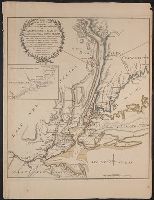
- Inset: Road from Amboy to Philadelphia.
- Publisher:
- Robt. Sayer and Jno. Bennett,
- Subject (Geographic):
- New York (State)--Maps--Early works to 1800 and United States--History--Revolution, 1775-1783--Maps--Early works to 1800
- Subject (Name):
- Robert Sayer and John Bennett (Firm)
- Found in:
- Beinecke Rare Book and Manuscript Library > The Seat of Action between the British and American Forces ... the Western part of Long Island ... Staten Island ... Amboy and New York ... Hudson's river from Courtland to Sandy Hook .... Surveys of Major Holland.