United States. Office of Strategic Services. Research and Analysis Branch
Published / Created:
1944
Call Number:
36 H17 1944
Container / Volume:
BRBL_00124
Image Count:
2
Resource Type:
Maps, Atlases & Globes
Description:
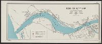
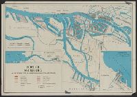
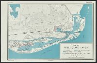
"No. 3440.", Inset maps: The Elbe Estuary. Scale [ca. 1:380,000] -- Cuxhaven. Scale [ca. 1:16,500], and Key to numbered basins, quays, warehouses and major shipyards on verso.
Publisher:
Reproduction Branch, OSS,
Subject (Geographic):
Elbe River Estuary (Germany)--Maps and Hamburg (Germany)--Maps
Subject (Topic):
Harbors--Germany--Cuxhaven--Maps and Harbors--Germany--Hamburg--Maps
United States. Office of Strategic Services. Research and Analysis Branch
Published / Created:
1945
Call Number:
304g 1945
Container / Volume:
BRBL_00034B
Image Count:
1
Resource Type:
Maps, Atlases & Globes
Description:
"No. 8186.", Includes regional map., Relief shown by pictorially., and Shows maximum tonnage of commercial vessels, major resources and industries, railroads, ports, 1937 international boundaries.
United States. Office of Strategic Services. Research and Analysis Branch
Published / Created:
1944
Call Number:
42ed K66 1944
Container / Volume:
BRBL_00245
Image Count:
1
Resource Type:
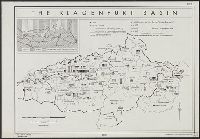
Maps, Atlases & Globes
Description:
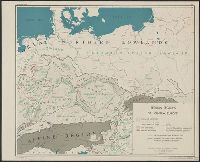
"From: Plebiscites since the World War, 1933, p. 167. By Sara [sic] Wambaugh.", "No. A-5378--R & A, OSS.", Inset map shows Yugoslav and German areas, and areas largely Germanized since 1851., and Shows boundaries of districts, communes and zones, and number of G
Publisher:
Reproduction Branch, OSS,
Subject (Geographic):
Carinthia (Austria)--Languages--Maps, Carinthia (Austria)--Maps, Carinthia (Austria)--Population--Maps, Slovenia--Languages--Maps, Slovenia--Maps, and Slovenia--Population--Maps
Subject (Name):
United States. Office of Strategic Services. Reproduction Branch and Wambaugh, Sarah, 1882-1955
Subject (Topic):
Slovenes--Austria--Carinthia--Maps and Yugoslavs--Austria--Carinthia--Maps