Jenkinson, Anthony, 1529-1611 Ortelius, Abraham, 1527-1598. Theatrum orbis terrarum Plantin, Christophe, approximately 1520-1589, printer
Call Number:
35 1562
Container / Volume:
BRBL_00099
Image Count:
1
Resource Type:
Maps, Atlases & Globes
Alternative Title:
Russiae, Moscoviae et Tartariae descriptio
Description:
"Cum priuilegio.", From Abraham Ortelius's Theatrum orbis terrarum (Antwerp, 1584)., Imperfect: slightly chipped along fold in center, with slight loss of text. Backed with paper., In Latin on verso., and Relief shown pictorially.
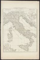
Anville, Jean Baptiste Bourguignon d', 1697-1782, cartographer
Call Number:
400 1764
Container / Volume:
BRBL_00233
Image Count:
1
Resource Type:
Maps, Atlases & Globes
Description:
Appeared in Anville's Atlas général., Hand colored in outline., Includes 2 insets of Rome city region and "Urbs septicollis.", Includes four bar scales., Relief shown pictorially., and Watermark.
Subject (Geographic):
Italy--Historical geography--Maps--Early works to 1800 and Rome--Maps
Subject (Name):
Anville, Jean Baptiste Bourguignon d', 1697-1782. Atlas général
Appears in N. Vischer's Atlas minor sive geographia compendiosa, 1684., In lower right margin: Gedruckt t'Amsterdam by Frederick de Wit voor inde Calverstraet by den dam inde witte Pascaart., Map of Russian Far East, China and, and Sheet measures 45.5 x 56.5 cm.
Subject (Geographic):
China--Maps--Early works to 1800, Japan--Maps--Early works to 1800, and Russia (Federation)--Maps--Early works to 1800
Subject (Name):
L'Huilier, Joannes, engraver and Visscher, Nicolaes, 1649-1702. Atlas minor
Mounted on linen., Relief shown pictorially., and Variant without inset of "Fort Frederick oder Crown Point"; see B.B. McCorkle, Early printed maps of New England 1513-1800, 755.34.
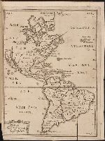
Kort beskrifning om provincien Nya Swerige uti America : som nu foertjden af the Engelske kallas
Image Count:
1
Description:
Preceding p. 1. and Teaching resource: Professor John Mack Faragher, History 141: The American West.
Subject (Geographic):
Canada --Discovery and exploration, South America --Discovery and exploration, United States --Discovery and exploration, and Western Hemisphere --Maps --Early works to 1800
Collection Created:
Stockholm : Tryckt uti Kongl. boktr. hos S. Wankijfs ankia, med egen bekostnad, af J. H. Werner, 1702
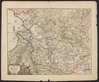
Mellinger, Johannes, approximately 1538-1603, cartographer
Call Number:
369 1650
Container / Volume:
BRBL_00146
Image Count:
2
Resource Type:
Maps, Atlases & Globes
Alternative Title:
Misniae et Lusatiae tabula, Misniae et Lvsatiae tabvla, and Tvringiae noviss. descript.
Description:
Bar scales given in "Scala miliarium Germanicorum.", Erroneous longitude numerals 20-30-31 in the right hand border of "Misniae et Lusatiae tabula.", From Abraham Ortelius' Theatr, In Latin on verso, with caption title "Turingia" and paginated 29., and Watermark.
Subject (Geographic):
Brandenburg (Germany)--Maps--Early works to 1800, Saxony (Germany)--Maps--Early works to 1800, Saxony-Anhalt (Germany)--Maps--Early works to 1800, and Thuringia (Germany)--Maps--Early works to 1800
Subject (Name):
Ortelius, Abraham, 1527-1598. Theatrum orbis terrarum. 1575 and Scultetus, Bartholomäus, 1540-1614
Imperfect: Mutilated with slight loss of information. Hand colored. Stamp: Karpinski-von Wieser Map Collection. "58"--Manuscript note in unidentified hand. and Relief shown pictorially.
Subject (Geographic):
Trentino-Alto Adige (Italy)--Maps--Early works to 1800