Skip to search
Skip to main content
Skip to first result
Search
You Searched For
Genre
Maps in books
Language
German
Language
Latin
New Search
Search Results
Published / Created:
MDCI [1601]
Call Number:
Taylor 193 3
Collection Title:
Tertia pars Indiae Orientalis ... / de Germanico in Latinum translata, & bono ordine disposita a
Image Count:
1
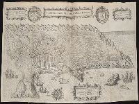
Description:
In pencil on verso: Part 3. p 40.
Subject (Geographic):
Angra dos Reis (Brazil)
Collection Created:
Francofurti : Excudebat Matthaeus Beckerus, anno MDCI [1601]
Found in:
Beinecke Rare Book and Manuscript Library > A cidade de Angra na ilhade ...
Published / Created:
MDCI [1601]
Call Number:
Taylor 193 3
Collection Title:
Tertia pars Indiae Orientalis ... / de Germanico in Latinum translata, & bono ordine disposita a
Image Count:
1
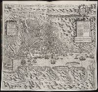
Description:
In pencil on verso: This map properly at page 73. Part 2.
Subject (Geographic):
Goa (India : State) --Maps and Goa --Description and travel
Collection Created:
Francofurti : Excudebat Matthaeus Beckerus, anno MDCI [1601]
Found in:
Beinecke Rare Book and Manuscript Library > A ilhae cidade de Goa metropolitana da Indiae partes orientais ...
Published / Created:
Undated
Call Number:
1983 Folio 19
Collection Title:
[Atlas factice of 96 maps by Blaeu, Visscher, Jansson, Hondius and others]
Image Count:
2
Publisher:
Apud Ioannem Ianssonium
Subject (Geographic):
Austria --Maps --Early works to 1800, Czechoslovakia --Maps, Germany --Maps --Early works to 1800, and Poland --Maps --Early works to 1800
Subject (Topic):
Atlases --Early works to 1800
Collection Created:
[1556-1680]
Found in:
Beinecke Rare Book and Manuscript Library > Bohemia
Creator:
Published / Created:
1750
Call Number:
1973 Folio 30
Collection Title:
[Atlas factice of 32 maps and 1 distance table, produced by the Homann Erben firm]
Image Count:
2
Publisher:
[Matthaeus Seutter?]
Subject (Geographic):
Nordhausen (Germany : Landkreis) --Maps --Early works to 1800
Subject (Topic):
Atlases, German --Early works to 1800
Collection Created:
[Nuremberg : s.n., 1701-1760]
Found in:
Beinecke Rare Book and Manuscript Library > Comitatus Stolbergensis delineatio geographia, Praefecturas Hohnstein, Stolberg, Hayn Berenroda, Ebersburg, Ufftrungen, Rosla et Questen cum limitibus et vicinia accurate exhibens / [cartographic material] / caelo Matthaei Seutteri. Georgraphi Caesarei ;
Creator:
Published / Created:
a. 1760
Call Number:
1973 Folio 30
Collection Title:
[Atlas factice of 32 maps and 1 distance table, produced by the Homann Erben firm]
Image Count:
2
Alternative Title:
Comitatus Schoenburgensis
Publisher:
Edentibus Homannianis Heredibus
Subject (Geographic):
Zwickau (Germany : Landkreis) --Maps --Early works to 1800
Subject (Topic):
Atlases, German --Early works to 1800
Collection Created:
[Nuremberg : s.n.,
Found in:
Beinecke Rare Book and Manuscript Library > Comitatvs Schoenburgensis [cartographic material] : in quo celsissimorum comitum de Schoenburg regiones ad circulum Saxoniae superiorem Imperii Romano-Germanici pertinentes et in Marchionatu Misniae sitae, subfeuda porro Bohemico-Imperialia, nempe Dynasti
Creator:
Published / Created:
1750
Call Number:
1973 Folio 30
Collection Title:
[Atlas factice of 32 maps and 1 distance table, produced by the Homann Erben firm]
Image Count:
2
Publisher:
[Matthaeus Seutter?]
Subject (Geographic):
Saxony-Anhalt (Germany) --Maps --Early works to 1800
Subject (Topic):
Atlases, German --Early works to 1800
Collection Created:
[Nuremberg : s.n., 1701-1760]
Found in:
Beinecke Rare Book and Manuscript Library > Delineatio geographica comitatus Mansfeldensis ad jurisdictionem tum Saxonicam tum Brandenburgicam spectans, cum praefectura Sangerhusana, Querfurtensi, Sittenbacensi, Allstaedensi, et loci finitimis / [cartographic material] / cura Matth. Seutteri, Geogr
Published / Created:
MDCI [1601]
Call Number:
Taylor 193 3
Collection Title:
Tertia pars Indiae Orientalis ... / de Germanico in Latinum translata, & bono ordine disposita a
Image Count:
1
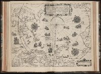
Description:
In pencil on verso: Part 3 p 132.
Subject (Geographic):
Arctic Ocean --Maps, Arctic regions --Discovery and exploration --Maps --Early works to 1800, Finland --Maps --Early works to 1800, Norway --Maps, and Sweden --Maps
Collection Created:
Francofurti : Excudebat Matthaeus Beckerus, anno MDCI [1601]
Found in:
Beinecke Rare Book and Manuscript Library > Deliniatio carta trium navigationum per Batavos ad Septentrionalem plaggem Norvegia, Moscovia et Novae Zembla ...
Creator:
Published / Created:
1780
Call Number:
1983 Folio 23
Collection Title:
[Atlas factice of 50 maps, primarily by Johann Baptist Homann and/or issued by the Homann Erben
Image Count:
1
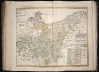
Alternative Title:
Tabula Marchionatus Brandenburgici & Ducatus Pomeraniae quae sunt pars septrionalis Circuli Saxionae Superioris
Publisher:
[Homann Erben]
Subject (Geographic):
Brandenburg (Germany) --Maps --Early works to 1800 and Pomerania (Poland and Germany) --Maps --Early works to 1800
Collection Created:
[Nuremberg : Homann Erben, 1710-1786]
Found in:
Beinecke Rare Book and Manuscript Library > Der noerdliche Theil des Obersaechsischen Kreises oder die Mark Brandenburg und das Herzogthum Pommern / [cartographic material] / aufs neue entworfen durch F.L.G. ; und ans Licht gestellet von den Homan[n] Erben = Tabula Marchionatus Brandenburgici & Duc
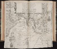
Published / Created:
MDCI [1601]
Call Number:
Taylor 193 3
Collection Title:
Tertia pars Indiae Orientalis ... / de Germanico in Latinum translata, & bono ordine disposita a
Image Count:
1
Description:
In pencil on verso: Part 3 P.?, Map cropped irregularly., and Small brown stain on lower left section of map above "Oceanus".
Subject (Geographic):
East Indies --Discovery and exploration, India Maps, and Indonesia Maps
Collection Created:
Francofurti : Excudebat Matthaeus Beckerus, anno MDCI [1601]
Found in:
Beinecke Rare Book and Manuscript Library > Descriptio Hydrograrhica ...
Creator:
Published / Created:
1758
Call Number:
1973 Folio 30
Collection Title:
[Atlas factice of 32 maps and 1 distance table, produced by the Homann Erben firm]
Image Count:
2
Publisher:
[Tobias Conrad Lotter]
Subject (Geographic):
Halle (Germany : Regierungsbezirk) --Maps --Early works to 1800 and Magdeburg (Germany : Regierungsbezirk) --Maps --Early works to 1800
Subject (Topic):
Atlases, German --Early works to 1800
Collection Created:
[Nuremberg : s.n., 1701-1760]
Found in:
Beinecke Rare Book and Manuscript Library > Ducatus Magdeburgensis et Halensis cum finitimis delineation geographica / [cartographic material] / curante Matthaeo Seuttero, Geographo. Caeser
Branch:v1.61.6 ,Deployed:2024-06-12T09:55:33-04:00