Skip to search
Skip to main content
Skip to first result
Search
You Searched For
Resource Type
Maps, Atlases & Globes
Publication Place
[S.l. :
New Search
Search Results
Published / Created:
ca. 1942]
Call Number:
36 Sa12 1942
Container / Volume:
BRBL_00126
Image Count:
2
Resource Type:
Maps, Atlases & Globes
Description:
[Western sheet] -- [Eastern sheet]. and Facsimile.
Publisher:
OSS?,
Subject (Geographic):
Saarbrücken (Germany)--Maps
Found in:
Beinecke Rare Book and Manuscript Library > [Facsimile map of Saarbrücken, Germany].
Published / Created:
1875?]
Call Number:
428 IN7 1875
Container / Volume:
BRBL_00248
Image Count:
1
Resource Type:
Maps, Atlases & Globes
Publisher:
s.n.,
Subject (Geographic):
Tyrol (Austria)--Maps
Found in:
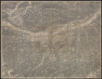
Beinecke Rare Book and Manuscript Library > [Innsbruck and Environs].
Published / Created:
1945?]
Call Number:
11hd 1945G-3
Container / Volume:
BRBL_00010ZF
Image Count:
1
Resource Type:
Maps, Atlases & Globes
Description:
Ms. notes in German. and Titile supplied by cataloger.
Publisher:
s.n.,
Subject (Geographic):
Baden-Württemberg (Germany)--Maps
Found in:
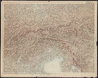
Beinecke Rare Book and Manuscript Library > [Karte des Deutschen Reiches 1:100,000, Ulm and vicinity]
Published / Created:
[1890?]
Call Number:
423 K88 1890
Container / Volume:
BRBL_00245
Image Count:
1
Resource Type:
Maps, Atlases & Globes
Description:
Title supplied by cataloger.
Publisher:
s.n.],
Subject (Geographic):
Lower Austria (Austria)--Maps
Found in:
Beinecke Rare Book and Manuscript Library > [Krems and Environs].
Published / Created:
1918?]
Call Number:
11hc 1918Z-2
Container / Volume:
BRBL_00010G
Image Count:
1
Resource Type:
Maps, Atlases & Globes
Description:
Legend shows the "Linea d'armistizio" and "Vecchio confine di Stato." and Title supplied by cataloger.
Publisher:
s.n.,
Subject (Geographic):
Europe, Eastern--Maps and Italy--Maps
Found in:
Beinecke Rare Book and Manuscript Library > [Linea d'Armistizio : Villa Giusti, 3 Novembre 1918].
Published / Created:
1919?]
Call Number:
11hcf 1919C-1-2
Container / Volume:
BRBL_00010S
Image Count:
1
Resource Type:
Maps, Atlases & Globes
Description:
Map drawn in crayon. and Title supplied by cataloger.
Publisher:
s.n.,
Subject (Geographic):
Balkan Peninsula--Maps
Found in:
Beinecke Rare Book and Manuscript Library > [Manuscript Map of the Balkan Peninsula].
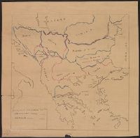
Published / Created:
1878?]
Call Number:
11hcf 1919C-1-1
Container / Volume:
BRBL_00010S
Image Count:
1
Resource Type:
Maps, Atlases & Globes
Description:
Legend indicates boundaries according to San Stefano in pink crayon, and boundaries according to Berlin in blue crayon. and Title supplied by cataloger.
Publisher:
s.n.,
Subject (Geographic):
Balkan Peninsula--Maps and Europe, Eastern--Maps
Subject (Topic):
Boundaries--Balkan Peninsula--Russo-Turkish War, 1877-1878 and Boundaries--Europe, Eastern--Russo-Turkish War, 1877-1878
Found in:
Beinecke Rare Book and Manuscript Library > [Manuscript Map showing boundaries according to the Treaty of Berlin and the Treaty of San Stefano].
Published / Created:
1919?]
Call Number:
11hcf 1919C-3-13
Container / Volume:
BRBL_00010U
Image Count:
1
Resource Type:
Maps, Atlases & Globes
Description:
Politcal boundaries outlined and labeled in pink. and Title supplied by cataloger.
Publisher:
s.n.,
Subject (Geographic):
Balkan Peninsula--Maps and Europe, Eastern--Maps
Found in:
Beinecke Rare Book and Manuscript Library > [Manuscript map of Balkan Peninsula and Eastern Europe].
Published / Created:
1919?]
Call Number:
11hcf 1919C-3-15
Container / Volume:
BRBL_00010U
Image Count:
1
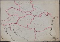
Resource Type:
Maps, Atlases & Globes
Description:
Area encompassing Bohemia, Moravia, Silesi, and Slovak districts outlined in yellow, green, and pink. and Title supplied by cataloger.
Publisher:
s.n.,
Subject (Geographic):
Balkan Peninsula--Maps and Europe, Eastern--Maps
Found in:
Beinecke Rare Book and Manuscript Library > [Manuscript map of Balkan Peninsula and Eastern Europe].
Published / Created:
1919?]
Call Number:
11hcf 1919C-4-1
Container / Volume:
BRBL_00010V
Image Count:
1
Resource Type:
Maps, Atlases & Globes
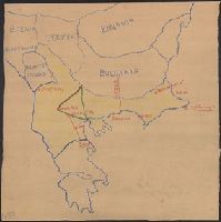
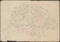
Description:
Ms. notes in orange showing areas of "Czech occupation" and the "Roumanian Occupation", and a blue notes: "Line of the Treaty of Belgrade" and "Feb. 1, 1919."
Publisher:
s.n.,
Subject (Geographic):
Hungary--Maps
Subject (Topic):
Boundaries--Hungary--Maps
Found in:
Beinecke Rare Book and Manuscript Library > [Manuscript map of Hungary].
Branch:v1.61.8 ,Deployed:2024-06-20T11:14:48-04:00