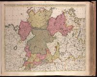
Appears in Valk and Schenk's Atlantis sylloge compendiosa, ca. 1702., Bar scales given in "milliaria Germanica communia" and "milliaria Gallica communia"., BEIN 1973 Folio 18: Imperfect: slight stains on verso and recto, with no loss of text. Backed with paper. Ms. no. in upper right corner: 22. Sheet measures 53.7 x 62.8 cm. No. 22 of 87 maps bound together., Prime meridian: Ferro., Relief shown pictorially., and Watermark.
Publisher:
Gerard Valck,
Subject (Geographic):
Germany, Northern--Maps--Early works to 1800.
Subject (Name):
Schenk, Peter, 1660-1718 or 1719. Atlantis sylloge compendiosa., Valck, G. (Gerard), 1651 or 1652-1726. Atlantis sylloge compendiosa., and Valck, Leonard, 1675-1746.
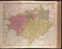
Appears in Valk and Schenk's Atlantis sylloge compendiosa, ca. 1702., Backed with paper. Ms. no. in upper right corner: 24. Sheet measures 53.7 x 62.7 cm. No. 24 of 87 maps bound together., Bar scales given in "milliaria Germanica communia" and "milliaria Gallica communia"., Prime meridian: Ferro., Relief shown pictorially., and Watermark.
Publisher:
Gerard Valck,
Subject (Geographic):
Brandenburg (Germany)--Maps--Early works to 1800., Saxony (Germany)--Maps--Early works to 1800., Saxony-Anhalt (Germany)--Maps--Early works to 1800., and Thuringia (Germany)--Maps--Early works to 1800.
Subject (Name):
Schenk, Peter, 1660-1718 or 1719. Atlantis sylloge compendiosa., Valck, G. (Gerard), 1651 or 1652-1726. Atlantis sylloge compendiosa., and Valck, Leonard, 1675-1746.
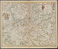
Bar scales given in "Milliaria Germanica communia" and "Milliaria Gallica communia"., Date inferred from C. Koeman's Atlantes Neerlandici, v. 3, p. 165 (Vis 10, map 7)., Prime meridian: Ferro., Relief shown pictorially., and Sheet measures 49.6 x 58.8
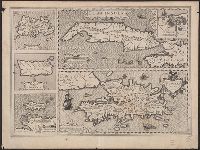
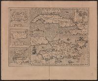
Ancillary maps: Insula Iamaica -- Ins. S. Ioannis -- Is. Margareta cum confinijis., Cuba Insula includes inset "Havana portus celeberimus totius indiae Occidentalis.", Latin text on verso; with caption title "Cuba, Hispaniola Iamai, and Relief shown pictorially.
Publisher:
Jodocus Hondius,
Subject (Geographic):
Cuba--Maps--Early works to 1800 and Hispaniola--Maps--Early works to 1800
Subject (Name):
Hondius, Jodocus, 1563-1612 and Mercator, Gerhard, 1512-1594. Atlas. French
Cuba Insula includes inset "Havana portus celeberimus totius indiae Occidentalis.", French text on verso; with caption title "Les isles de la Cuba, Espaignole, Iamaique, de S. Iean et Margarite," paginated 701, 704, with signatures 8P., and Relief shown pictorially.
Publisher:
Hendrik Hondius,
Subject (Geographic):
Cuba--Maps--Early works to 1800 and Hispaniola--Maps--Early works to 1800
Subject (Name):
Hondius, Hendrik, 1597-1651 and Mercator, Gerhard, 1512-1594. Atlas. French
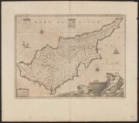
Bar scales given in "milliaria Italica" and "milliaria Germanica"., From Joan Blaeu's Atlas maior. Amstelaedami : ... Ioannis Blaeu, 1662., In Latin on verso; running title "Cyprus Insula," paginated 25-26, with signature I., Prime meridian: Ferro., and Relief sh
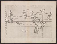
From Herrera y Tordesillas's Descripción de las Indias Occidentales ... Amstelodami : Apud M. Colinium, 1622., Map of the World from China, west to Spain showing the 'Merida, Relief shown pictorially., and Sheet measures 28.5 x 36.9 cm. Cross Collection no. 112.
Publisher:
Michiel Colijn,
Subject (Geographic):
World maps--Early works to 1800
Subject (Name):
Colijn, Michiel, Herrera y Tordesillas, Antonio de, d. 1625. Descripción de las Indias Occidentales. Latin, and Portugal.--Treaties, etc.--Spain--(1494 June 7)
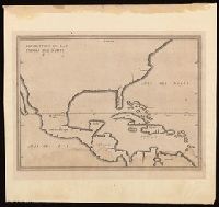
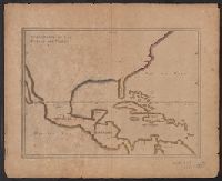
Appears in French eds. of Herrera y Tordesilla's Descripción de las Indias Occidentales published in Amsterdam., Sheet measures 28.7 x 35.2 cm. Cross Collection no. 227., and Shows coasts of the southern part of North America, Central America, northern coast of South America, and West Indies.
Publisher:
Michiel Colijn,
Subject (Geographic):
America--Maps--Early works to 1800., Central America--Maps--Early works to 1800., and West Indies--Maps--Early works to 1800.
Subject (Name):
Colijn, Michiel, publisher. and Herrera y Tordesillas, Antonio de, -1625. Descripción de las Indias Occidentales. French.
Appears in French eds. of Herrera y Tordesilla's Descripción de las Indias Occidentales published in Amsterdam., Sheet measures 28.7 x 35.2 cm. Cross Collection no. 227., and Shows coasts of the southern part of North America, Central America, northern coast of South America, and West Indies.
Publisher:
s.n. ,
Subject (Name):
Herrera y Tordesillas, Antonio de, d. 1625. Descripción de las Indias Occidentales. French
Subject (Topic):
Coasts--Central America--Maps--Early works to 1800, Coasts--North America--Maps--Early works to 1800, Coasts--South America--Maps--Early works to 1800, and Coasts--West Indies--Maps--Early works to 1800