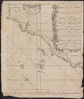
Terra neuf, en de custen van Nieu Vranckryck, Nieu Engeland, Nieu Nederland, Nieu Andalusia, Guiana en Venezuela
Description:
Covers the Atlantic Ocean west of the Azores and Cape Verde Islands, and the coasts of northeastern North America and northern South Amerca., In Latin and Dutch., Includes two decorative cartouches and ill., Ms. "25" in upper right margin., and Oriented with nort
Publisher:
Gedruckt by Fredrick de Wit in de Kalverstraet,
Subject (Geographic):
North Atlantic Ocean--Maps--Early works to 1800
Subject (Topic):
Nautical charts--North Atlantic Ocean--Early works to 1800
Gastaldi, Giacomo, approximately 1500-approximately 1565
Published / Created:
[1897]
Call Number:
11 1546
Image Count:
1
Resource Type:
Maps, Atlases & Globes
Alternative Title:
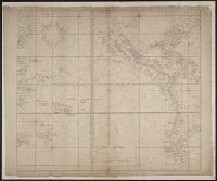
Remarkable maps of the XVth, XVIth and XVIIth centuries ; pt. 4, no. 8., Reproductions of geographical maps ; [pt. 4, no. 8], and Universale
Description:
Facsimile., Relief shown pictorially., Series title commonly cited as Remarkable maps of the XVth, XVIth and XVIIth centuries., and World map on an oval projection.
Publisher:
Frederik Muller,
Subject (Topic):
Early maps, Early maps--Facsimiles, World maps, and World maps--Early works to 1800--Facsimiles
From Chatelain's Atlas historique et methodique. Amsterdam : Guedeville, 1719., In top right hand corner: Tom: V. No. 56. Pag: 172., Sheet measures 44.5 x 54 cm, and Six views of Japan on one sheet with text.