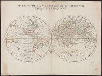
Description generale du globe terrestre et aquatique en deux-plans-hemispheres and Mappe-monde geo-hydrographique
Description:
"Presenté a Monseigneur le Dauphin, par son tres-humble, tres-obeissant et tres-fidele feruiteur, Hubert Jaillot"--Cartouche., Cross collection no. 27., Imperfect: chipped along edges, with no loss of text. Plate IV, state 3 (cf. Shirley 462)., Includes surrounding decorative illustrations., One of a number of printings from a map first drawn by Nicolas Sanson in 1674; later issued in Jaillot's Atlas nouveau [1681 and onwards]., and Relief shown pictorially.
Publisher:
Hubert Jaillot,
Subject (Name):
Jaillot, Alexis Hubert, 1632?-1712 and Jaillot, Alexis Hubert, 1632?-1712. Atlas nouveau
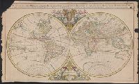
Description generale du globe terrestre et aquatique en deux-plans-hemispheres and Mappe-monde geo-hydrographique
Description:
Imperfect: Torn along center fold, with some loss of text. Hand col. Sheet measures 64 x 100 cm. Ms. stamp on verso: Horace Brown 1900S., Includes surrounding decorative illustrations., and One of a number of printings from a map first drawn by Nicola
Plan de la ville de Vienne et ses environs par le Sr. Sanson
Description:
"Avec privilege du roy"., Appears in Jaillot's Atlas françois; cf. Pastoure, Bar scales given in "lieue commune d'Allemagne," "grande lieue d'Allemagne," and "lieue d'une heure de chemin"., Relief shown pictorially., Sheet measures 62.8 x 97.5 cm., and Watermark.
Publisher:
Chez H. Iaillot joignant les grands Augustins aux deux globes,
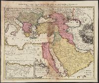
Imperium Turcicum, complectens Europae, Asiae et Africae, Arabiae que regiones ac provincias plurimas, industria et labore Sr. Sanson
Description:
Includes four bar scales., Inset map [partially obscuring title in cartouche] is continuation of the North African coastline., Prime meridian: Ferro., Reinforced on back with paper. Sheet measures 51.5 x 61.0 cm., and Relief shown pictorially.
Publisher:
s.n.,
Subject (Geographic):
Africa, North--Maps--Early works to 1800, Europe, Southern--Maps--Early works to 1800, Middle East--Maps--Early works to 1800, and Turkey--Maps--Early works to 1800