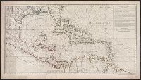
Below title in cartouche: "Met privilegio voor 15 iaaren ao 1687.", Depths shown by soundings., Dutch and French., Inset map: Le partie du Carolina grand point., and Sheet measures 44.3 x 56.7 cm. Cross Collection no. 220.
Publisher:
s.n.],
Subject (Geographic):
Atlantic Coast (South Atlantic States)--Nautical charts--Early works to 1800 and South Carolina--Nautical charts--Early works to 1800
Subject (Topic):
Nautical charts--Atlantic Coast (South Atlantic States)--Early works to 1800 and Nautical charts--South Carolina--Early works to 1800
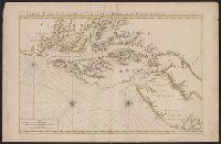
"4 e. feuille.", "No. 5" in lower right corner., Prime meridian: Paris., Relief shown pictorially. Depths shown by soundings., Shows English ownership of Florida., and Stamped no. "107" and title "Golfe du Mexique" on verso. Cross Collection no. 246.
Publisher:
Sur ley Quay de la Megisserie prés le Pont Neuf ...,
Subject (Geographic):
Caribbean Area--Maps--Early works to 1800
Subject (Name):
Buache, Philippe, 1700-1773. Atlas géographique et universel, L'Isle, Guillaume de, 1675-1726. Atlas géographique et universel, and Popple, Henry, -1743
Subject (Topic):
Nautical charts--Caribbean Area--Early works to 1800
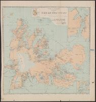
Hand col. Mounted on linen. Sheet measures 65 x 49 cm. Ms. n, Has watermarks., Includes index and ill., Oriented with north to the bottom., Relief shown by hachures. Depths shown by soundings., and Shows fortifications and coastal defenses in the Gibraltar region.
Publisher:
Chez Basset, rue St. Jacques, au coin de delle des Mathurins,
Subject (Geographic):
Gibraltar, Bay of (Spain)--Maps--Early works to 1800
Subject (Name):
Coquart, A
Subject (Topic):
Coast defenses--Spain--Gibraltar, Bay of--Maps--Early works to 1800 and Fortification--Spain--Gibraltar, Bay of--Maps--Early works to 1800
Neptune françois, ou, Atlas nouveau des cartes marines.
Description:
Appears in: Le Neptune françois, ou, Atlas nouveau des cartes marines, various eds., Covers coasts of Virginia, Maryland, Delaware, New, Described in Coolie Verner's Printed maps of Virginia, 1590-1800, p. 402., Nautical chart., and Oriented with north to right.
Publisher:
Chez P. Mortier,
Subject (Geographic):
Middle Atlantic States--Maps--Early works to 1800
Subject (Name):
Mortier, Pierre
Subject (Topic):
Coasts, Coasts--Delaware--Maps--Early works to 1800, Coasts--Maryland--Maps--Early works to 1800, Coasts--New Jersey--Maps--Early works to 1800, and Nautical charts--Chesapeake Bay (Md. and Va.)--Early works to 1800
"La géographie. Tome XXXVII.", Insets: Superficie de Kerguelen, comparée à celle de la Corse -- Port Curieuse -- Océan indien., and Relief shown by contours and spot heights. Depths shown by soundings.
Publisher:
Société de géographie,
Subject (Geographic):
Kerguelen Islands--Maps
Subject (Name):
Hansen, Jules, 1849-1931, Loranchet, Jean, Rallier du Baty, Henri, Rallier du Baty, Raymond, 1881-, Saint-Lanne Gramont, Georges, and Société de géographie (France)
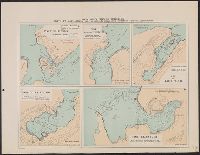
Océan indien (Iles de Kerguelen). Deuxième feuille. and Ports et mouillages, levés au cours du voyage de la "Curieuse", 1913-1914 (deuxième feuille)
Description:
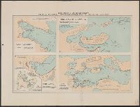
7. Port Couvreux -- 8. Port Roland Bonaparte -- 9. Port Matha -- 10. Port d'Hiver. and Inset map: Iles de Kerguelen ...
Océan indien (Iles de Kerguelen). Première feuille. and Ports et mouillages, levés au cours du voyage de la "Curieuse", 1913-1914 (première feuille)
Description:
[1.] Port Fallières -- [2.] Port Edmond Perrier -- [3.] Baie du Yacht-Club -- [4.] Port Jules Girard -- [5.] Port Elisabeth.
Publisher:
[Société de géographie,
Subject (Geographic):
Kerguelen Islands--Nautical charts
Subject (Name):
Curieuse (Boat)--Nautical charts and Société de géographie (France)
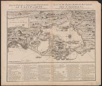
Cross Collection no. 334., In French and Dutch., Includes a numbered key indicating the locations of the French and English fleets during the raid on Cartagena in 1697., Ms. no. on verso: No. 103., and Oriented with north towards up
Publisher:
Chez Covens et Mortier,
Subject (Geographic):
Cartagena (Colombia)--History--Siege, 1741--Maps and Cartagena (Colombia)--Maps--Early works to 1800