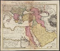
Imperium Turcicum, complectens Europae, Asiae et Africae, Arabiae que regiones ac provincias plurimas, industria et labore Sr. Sanson
Description:
Includes four bar scales., Inset map [partially obscuring title in cartouche] is continuation of the North African coastline., Prime meridian: Ferro., Reinforced on back with paper. Sheet measures 51.5 x 61.0 cm., and Relief shown pictorially.
Publisher:
s.n.,
Subject (Geographic):
Africa, North--Maps--Early works to 1800, Europe, Southern--Maps--Early works to 1800, Middle East--Maps--Early works to 1800, and Turkey--Maps--Early works to 1800
"Office of Economic Warfare, Cartographic section, Map information unit"--Stamped in the lower right margin., In lower left corner: No. 786, GDSS., Includes distances between destinations and inset map of Corsica., and Title supplied by cataloger.
"Bearbeitet und gedruckt im August 1918. Stoverm. 7", "Bearbeitet und gedruckt von der Verm.Abt. 14, Gr.Kartenstelle IV.", "ENTWURF" stamped on upper left of map., "Stand vom 7.Sept.18.", French and German., and Printed col. legend corresponding to printed notes o
Possibly by Alexandre Berthier, of the famous meeting between the Comte de Rochambeau and General Washington at the Hudson River on the famous march from Providence, Rhode Island to join with the American troops.
Backed with paper., Copied from plate 9 in Alexandre de Humboldt's Atlas geographique et physique du royaume de la Nouvelle-Espagne., Imperfect: mutilated along folds., Relief shown by hachures., and Title devised by cataloger.
Subject (Geographic):
Veracruz-Llave (Mexico : State)
Subject (Name):
Humboldt, Alexander von, 1769-1859. Atlas geographique et physique du royaume de la Nouvelle-Espagne.