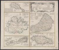
Cross Collection no. 245., Imperfect: map of Jamaica cut-out. Two maps (Antigua and Barbados)., Includes explanatory notes and index., Relief shown pictorially., Scales in millaria Anglica communia and/or millaria Anglica statuta., and Sheet title in Latin and German. Individual map titles and text in German. Maps in English and German.
Publisher:
Homann Erben,
Subject (Geographic):
Antigua--Maps--Early works to 1800, B, Barbados--Maps--Early works to 1800, Jamaica--Maps--Early works to 1800, Saint Kitts and Nevis--Maps--Early works to 1800, and West Indies--Maps--Early works to 1800
Cross Collection no. 253., Includes explanatory notes and index., Ms. notes in upper right corner., Relief shown pictorially., Scales in millaria Anglica communia and/or millaria Anglica statuta., Sheet title in Latin and German. Individual map titles and text in German. Maps in English and German., and Three maps (Antigua, Barbados, Jamaica). Mounted on linen.
Publisher:
Homann Erben,
Subject (Geographic):
Antigua--Maps--Early works to 1800, Barbados--Maps--Early works to 1800, Bermuda Islands--Maps--Early works to 1800, Jamaica--Maps--Early works to 1800, and Saint Kitts and Nevis--Maps--Early works to 1800
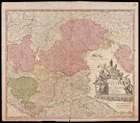
"Cum privilegio Sac. Caes. Majestatis.", Bar scales given in "milliaria Germanica," "milliaria Gallica," and ""milliaria Italica.", Manuscript number in upper right corner: 43. From the Karpinski-von Wieser Map Collection., and Relief shown pictorially.
Publisher:
[Johann Baptist Homann]
Subject (Geographic):
Italy, Northern--Maps--Early works to 1800. and Veneto (Italy)--Maps--Early works to 1800.
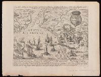
Hogenberg, Frans, approximately 1539-1590, creator
Published / Created:
[1612?]
Call Number:
BrSides 2019 69
Image Count:
1
Resource Type:
Maps, Atlases & Globes
Alternative Title:
Eigentliche abbildung der Starken Vestung La'rache ein furnhemer Meerhaven in Barbarien, welche, in Nahmen Königlicher Majest. von Hispanien durch den Marckgraven von S.Germein ist eingenomen worden Ao. 1610 im Nove[m]b
Description:
Four lines of verse in two columns in Latin and four lines of verse in two columns in German in lower margin, with explanatory text below., North oriented towards the left., Relief shown pictorially., Removed from Georg Braun's Civitates orbis terrarum., and Watermark.
Publisher:
[Georg Braun and Franz Hogenberg],
Subject (Geographic):
Larache (Morocco)--Maps--Early works to 1800.
Subject (Name):
Braun, Georg, 1540 or 1541-1622. Civitates orbis terrarum and Hogenberg, Abraham, active 1608-1653, printer
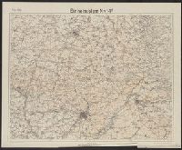
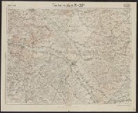
"Die braunen Schichtlinien umgrenzen Stufen von 10 meter Höhen-Abstand.", "Febr.1918." above upper left margin., "Kartographische Abteilung d. Kgl. Preuβ. Landesaufnahme.", German and French., Includes index of connecting sheets., and Shows area surrounding St. Q
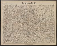
"Die braunen Schichtlinien umgrenzen Stufen von 10 meter Höhen-Abstand.", "Febr.1918." above upper left margin., "Kartographische Abteilung d. Kgl. Preuβ. Landesaufnahme.", German, Includes index of connecting sheets., and Shows area surrounding Soissons, France.
"April.1918." above upper left margin., "Die braunen Schichtlinien umgrenzen Stufen von 10 meter Höhen-Abstand.", "Kartographische Abteilung d. Kgl. Preuβ. Landesaufnahme.", German and French., Includes index of connecting sheets., and Shows area surrounding Chal