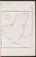
Manuscript map in blue and red ink depicting the original nine squares. This map is possibly the original drawing by James Wadsworth, drawn from actual surveys.
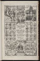
[Hakluytus posthumus] , Hakluytus posthumus or Purchas his pilgrimes., Map of China., New France., and Purchas his pilgrimes in five bookes.
Description:
Accompanied by ALS ([4] p.) to Charles Deane, Cambridge, from Henry Stevens, dated London, Jan. 23, 1875. Uncancelled states of v. 1 G3 and 4M4,5. Vol. 1: [1] Description of East India (27.1 x 35.3 cm, on sheet 33.7 x 38.5 cm) bound in following p. 578; vol. 3: [1] The map of China (27.5 x 34.3 cm, on sheet 33.8 x 37.2 cm) bound in following p. 400; [2] The north part of America (27.4 x 33.3 cm, on sheet 34 x 37.5 cm) bound in following p. 852; vol. 4: [1] Virginia (31.5 x 39.6 cm, on sheet 33.9 x 40 cm, folded to 33.7 x 18.5 cm) bound in following p. 1690; [2] New France (24.9 x 32.7 cm, on sheet 34 x 37.7 cm) bound in following p. 1872.
Publisher:
Printed by William Stansby for Henrie Fetherstone, and are to be sold at his shop in Pauls Church-yard at the signe of the Rose,
Subject (Geographic):
America--Discovery and exploration--Early works to 1800
Subject (Topic):
Geography--Early works to 1800, Religions--Early works to 1800, and Voyages and travels--Early works to 1800
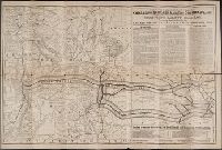
The Union Pacific Ry. through Kansas or Nebraska to the Colorado. Mines and resorts
Image Count:
1
Subject (Geographic):
Colorado --Description and travel, Kansas --Description and travel, Missouri River Valley --Description and travel, and Nebraska --Description and travel
Atlas minor: or a set of sixty-two new and correct maps, of all parts of the world. All composed
Image Count:
1
Description:
Autograph of Gravely. Autograph of Baldock. Autograph of Aston. Autograph of W. Alington. and Teaching resource: Professor John Mack Faragher, History 141: The American West.