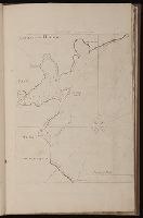
The diaries describe an 1849 expedition by way of St. Joseph, Fort Kearney, Fort Laramie, South Pass, Sublette's Cut-off, Bear River, Cantonment Loring, Raft River, the Humboldt, Lassen's Route to Deer Creek, and Bruff's camp. They contain maps and sketches from the journey and notes on life in California. The journals were written from the diaries. The notebooks contain more sketches from the trip and of equipment. There are memoranda of supplies and equipment, routes, and remedies.
Alternative Title:
Emmigration, across the continent, in 1849, to
Subject (Geographic):
California --Description and travel, West (U.S.) --Description and travel, West (U.S.) --Maps, and West (U.S.) --Pictorial works
Subject (Name):
Bruff, Joseph Goldsborough, 1804-1889 and Washington City and California Mining Association
Subject (Topic):
Gold mines and mining --California --History --19th century --Personal narratives, Gold mines and mining --North America --History --19th century, Gold mines and mining --Sierra Nevada (Calif. and Nev.), Gold mines and mining --United States --History, and Gold mines and mining --West (U.S.) --History --19th century
[Atlas factice of 96 maps by Blaeu, Visscher, Jansson, Hondius and others]
Image Count:
2
Resource Type:
Maps, Atlases & Globes
Description:
All four sides of map decorated with city views and costumed figures of different social classes. Includes coats of arms., Imperfect: torn along fold, with some loss of text; portions of decorative border cut or torn and repaired, with missing sections replicated in ms.; tears repaired., and No. 5 of 92 maps bound together.
[Atlas factice of 32 maps and 1 distance table, produced by the Homann Erben firm]
Image Count:
2
Alternative Title:
Carte des XVII. provinces ou de l’Allemagne inferievre, dressee suivant la projection stereographique, et appueyee par les mesures faites de Mess. Cassini, Snellius et Mouschenbrok, par Mr. Tob. Majer de la Societe geographique, et publiee par les Heritiers de Homann, l’An 1748
Publisher:
Cura et Studio Homannianorum Heredum
Subject (Geographic):
Belgium --Maps --Early works to 1800, Benelux countries --Maps --Early works to 1800, Luxembourg --Maps --Early works to 1800, and Netherlands --Maps --Early works to 1800
[Atlas factice of 32 maps and 1 distance table, produced by the Homann Erben firm]
Image Count:
2
Alternative Title:
Belgium Catholicum seu decem provinciae Germaniae inferioris and Carte des Pais Bas catholiques ou des X provinces de l’Allegmagne inferieure, etc. dessinee au juste selon les exactes observations astronomiques et operations geometriques des Messur. Cassini, Snellius, Muschenbrok, etc. dressee par Sr. Tobias Maier, mathematicien; aux depens des Heritiers de Homann
Subject (Geographic):
Belgium --Maps --Early works to 1800 and Luxembourg --Maps --Early works to 1800