Homann Erben (Firm) Homann, Johann Baptist, 1663-1724
Published / Created:
1728?
Call Number:
1973 Folio 30
Collection Title:
[Atlas factice of 32 maps and 1 distance table, produced by the Homann Erben firm]
Image Count:
3
Alternative Title:
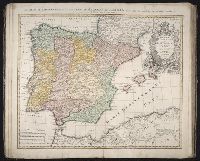
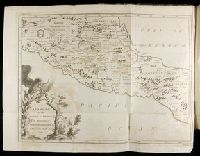
Regnorum Hispaniae et Portugalliae tabula generalis de l’Isliana and Reyno de Espanna dividido en dos grandes estados de Aragon y de Castilla, subdividido en muchas provincias donde se halla tambien el Reyno de Portugal
Publisher:
[Homann Erben]
Subject (Geographic):
Portugal --Maps --Early works to 1800 and Spain --Maps --Early works to 1800
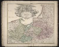
[Atlas factice of 96 maps by Blaeu, Visscher, Jansson, Hondius and others]
Image Count:
2
Description:
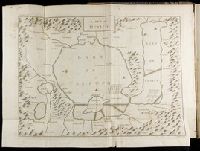
Imperfect: cartouche cut-out and replaced in ms. Sheet measures 38.1 x 49.3 cm. Reinforced along edges with printed waste. No. 84 of 92 maps bound together. and Numbered 90 on verso.
Publisher:
Apud Guiljelmum Blaeu
Subject (Geographic):
Salzburg (Austria : Land) --Maps --Early works to 1800
Descriptio ac delineatio geographica detectionis freti, sive, transitus ad occasum supra terras
Image Count:
1
Abstract:
Map depicts the Coat of Arms of the United Kingdom (era of the Union of the Crowns), reigning between the years 1603-1707.
Alternative Title:
Tabula nautica ...
Description:
Bound in after p. [6]., In ink on recto: place names "Okkak", "Nain"[?] and one longer handwritten note on the bottom margin., Map cut and folded irregularly., Map has been repaired with multiple pieces of tape on verso., Map has multiple small stains on both the recto and verso., Printed on recto in lower right corner: A1., and Scale [ca. 1:9,000,000].
Subject (Geographic):
North Atlantic Ocean --Maps --Early works to 1800
Subject (Name):
Hudson, Henry, d. 1611
Collection Created:
Amsterodami Ex officina Hesse lij Gerardi. Anno 1613
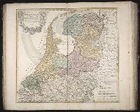
Kingdom of France divided into all its provinces, comprehended under twelve generall governments viz. ... described by Sanson, corrected and amended by William Berry
Description:
Bar scales given in Italian miles, common leagues of France, great leagues of France, common leagues of Germany, great leagues of Germany, English miles, and common leagues of Spain., Ms. mathematical computations on right margin., No. 12 of 69 maps bound together in composite atlas., Relief shown pictorially., Scale [ca. 1:2 100 000]., and With dedication To the most serene and most sacred Majesty Charles II ... from William Berry.
Publisher:
Sold by William Berry at the sign of the Globe between Charing-Cross and White-Hall
Subject (Geographic):
Europe, Central --Maps --Early works to 1800 and France --Maps --Early works to 1800