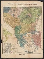
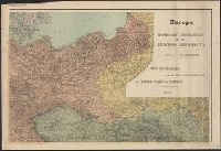
Ms. notes in red and yellow ink, outlining "Ceded Territory," and areas inhabited by different ethnic groups. "Ceded Territory" may refer to lands acquired by Russia at the end of the Russo-Turkish War of 1877-1878.
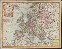
L'Isle, Guillaume de, 1675-1726 Lotter, Tobias Conrad, 1717-1777
Published / Created:
176-?]
Call Number:
30 1720A
Container / Volume:
BRBL_00029
Image Count:
1
Resource Type:
Maps, Atlases & Globes
Description:
Cartouche with Apollo and Athena at bottom., Includes eight bar scales., Prime meridian: Ferro., Relief shown pictorially., and Sheet measures 48.5 x 61.6 cm.
"Mapa reproducido por los Talleres Gráficos del Estado Mayor del Ejército.", 2 copies of each sheet., Includes 3 inset maps: Berlin, Potsda -- Wien und weitere Umgegend -- Paris und Umgebung., and Relief shown by hachures; depths shown by isolines.
Publisher:
Talleres Gráficos del Estado Mayor del Ejército,
"Mapa reproducido por los Talleres Gráficos del Estado Mayor del Ejército.", Includes 3 inset maps: Berlin, Potsda -- Wien und weitere Umgegend -- Paris und Umgebung., and Shows borders, topographic features, cities and towns, provinces, ports, and major tran
Publisher:
Talleres Gráficos del Estado Mayor del Ejército,
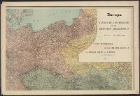
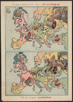
Año despues !!la realidad!! and Serio-comique map of Europe at war.
Description:
After Johnson, Riddle & Co.'s Serio-comique map of Europe at war., Caricature map., Countries are represented by drawings of people, animals, etc. to depict wartime attitudes., and Within neat line of Europa al principio de la guerra: Hark! Hark! The dogs do bar
Publisher:
s.n.,
Subject (Geographic):
Europe--Maps and Europe--Politics and government--Maps
Subject (Topic):
World War, 1914-1918--Caricatures and cartoons and World War, 1914-1918--Maps