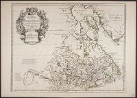
Appeared in L'Isle's Atlas géographique et universal., Includes descriptive text., Lower left: Ph. Buache ... Gendre de l'auteur, avec Privilege du 30 Au. 1745., Relief shown pictorially., and Sheet measures 54.7 x 76.5 cm. Ms. nos. on verso: 52.
Publisher:
Philippe Buache],
Subject (Geographic):
Canada--Maps--Early works to 1800 and New France--Maps--Early works to 1800
Subject (Name):
Buache, Philippe, 1700-1773 and L'Isle, Guillaume de, 1675-1726. Atlas géographique et universal
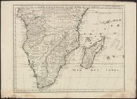
"Avec privilege Janvier 1708.", "The words 'premier geographe du Roi' added in the title ... [indicate] that [a map] could not have been issued before 1718 when [De l'Isle] was appointed to that office"--Tooley, R.V. Guide to maps, and Relief shown pictorially.
Publisher:
chez l'auteur sur le Quai de l'Horloge,
Subject (Geographic):
Africa, Central--Maps--Early works to 1800 and Africa, Southern--Maps--Early works to 1800
[American maps ; v. 1, no. 8] and Library of Congress. American maps ; v. 1, no. 8.
Description:
Imprint date from R.V. Tooley's French mapping of the Americas, item 50., Prime meridian: Ferro., Relief shown pictorially., and Yale's copy stamped on verso: Yale University Library, Karpinski-Von Wieser Map Collection.
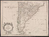
Appears in L'Isle's Atlas de géographie. Paris : Guillaume DeLisle, Quai de l'Horloge, 1731., Or, Relief shown pictorially., Sheet measures 54.9 x 74.6 cm., and Shows routes of Magellan, Sarmiento, Brower, Beauchesne, Sharp, Sr. de la Roche, Halley and Vespucci.
Publisher:
Chez l'auteur sur le Quai de l'Horloge ...,
Subject (Geographic):
South America--Maps--1708-1718 and South America--Maps--Early works to 1800
Subject (Name):
Liebaux, engraver, L'Isle, Guillaume de, 1675-1726. Atlas de géographie, and Simonneau, Charles, 1645-1728
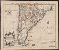
Appears in L'Isle's Atlas de géographie. Paris : Guillaume DeLisle, Quai de l'Horloge, 1731., Imprint of Louis Renard Libraire, Mounted in linen. Sheet measures 51.8 x 69.7 cm., Ornamental cartouche by "C. Simonneau inv. et fecit.", and Relief shown pictorially.
Publisher:
Chez l'auteur sur le Quai de l'Horloge ...,
Subject (Geographic):
South America--Maps--1708-1718 and South America--Maps--Early works to 1800
Subject (Name):
Liebaux, engraver, L'Isle, Guillaume de, 1675-1726. Atlas de géographie, and Simonneau, Charles, 1645-1728
Tabula geographica Paragaiae, Chilis, Freti a Magellanici &c
Description:
Appears in Cóvens and Mortier's Atlas nouveau; cf. Koeman, C. Atlantes Neerlandici, II C & M 4., Bar scales given in "lieues marines d'Espagne" and "lieues comm. d'Espagne"., Cross Collection no. 327., Mounted in linen., Relief shown pictorially., and Shows southern part of South American continent.
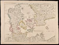
"Avec privilege du 30 Av. 1745"., Imprint in lower left: "A Paris chez l'auteur ... ", Prime meridian: Ferro., Relief shown pictorially., and Watermarks. Sheet measures 54 x 72 cm. Manuscript note on verso: 30.
Publisher:
Ph. Buache ...
Subject (Geographic):
Denmark--Maps--Early works to 1800., Schleswig-Holstein (Germany)--Maps--Early works to 1800., and Sweden--Maps--Early works to 1800.